Medway Gap
The Medway Gap is a topographic feature in Medway near Rochester in South East England.

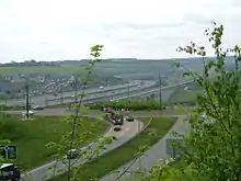
It was created when the prehistoric River Medway cut through line of chalk hills now known as the North Downs;[1] other rivers such as the Darent and the Stour have similar features.
Its past significance as a means of travel is indicated by the prehistoric Medway megaliths in the area. Today a local rail route and a relatively major road (the A228) utilise the valley. The river here is bridged by the M2 motorway and High Speed 1 viaducts.
It also has the effect of creating local weather patterns, thereby frequently exhibiting opposite conditions to the surrounding countryside.
Planning
The "Medway Gap" covers the small towns in this area within Tonbridge and Malling: Aylesford, East Malling, Eccles, Larkfield, Leybourne, Snodland and West Malling.
References
- Kev Reynolds (1 Aug 2001). The North Downs Way. Cicerone Press Limited. Retrieved 9 June 2012.