Ásbyrgi
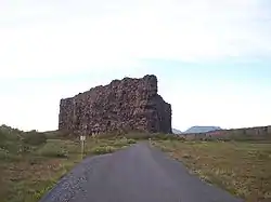
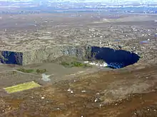
Ásbyrgi is a glacial canyon and forest in the north of Iceland, located approximately 38 kilometres (24 mi) east of Húsavík on the Diamond Circle road. The horseshoe-shaped depression is part of the Vatnajökull National Park and measures approximately 3.5 km in length and over 1 km wide.[1] For more than half of its length, the canyon is divided through the middle by a distinctive rock formation 25 meters high called Eyjan ("the Island"), from which a vast landscape is seen.
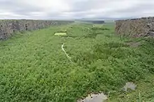
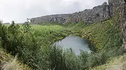
The canyon's steep sides are formed by cliffs up to 100 metres (330 ft) in height. Within in the canyon is a woodland of birch and willow. Between 1947 and 1977, a number of foreign tree species were introduced, including spruce, larch and pine. The small lake Botnstjörn is home to a variety of waterfowl species.
Ásbyrgi was most likely formed by catastrophic glacial flooding of the river Jökulsá á Fjöllum after the last Ice Age, first 8-10,000 years ago, and then again some 3,000 years ago. The river has since changed its course and now runs about 2 km to the east. The legend explains the unusual shape of the canyon differently. Nicknamed Sleipnir's footprint, it is said that the canyon was formed when Odin's eight-legged horse, Sleipnir, touched one of its feet to the ground here.
References
- "About Ásbyrgi". Vatnajökull National Park.
External links
| Wikimedia Commons has media related to Ásbyrgi. |
- Photos
- Pictures from Ásbyrgi www.islandsmyndir.is
- Official Website of Vatnajökull National Park