Acqueville, Calvados
Acqueville is a former commune in the Calvados department in the Normandy region of northwestern France. On 1 January 2019, it was merged into the new commune of Cesny-les-Sources.[2]
Acqueville | |
|---|---|
Part of Cesny-les-Sources | |
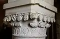
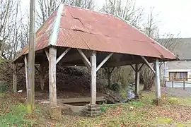 The lavoir at Acqueville | |
Location of Acqueville 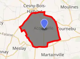
| |
 Acqueville  Acqueville | |
| Coordinates: 48°58′20″N 0°21′56″W | |
| Country | France |
| Region | Normandy |
| Department | Calvados |
| Arrondissement | Caen |
| Canton | Thury-Harcourt |
| Commune | Cesny-les-Sources |
| Area 1 | 6.65 km2 (2.57 sq mi) |
| Population (2017)[1] | 189 |
| • Density | 28/km2 (74/sq mi) |
| Time zone | UTC+01:00 (CET) |
| • Summer (DST) | UTC+02:00 (CEST) |
| Postal code | 14220 |
| Elevation | 126–211 m (413–692 ft) (avg. 150 m or 490 ft) |
| 1 French Land Register data, which excludes lakes, ponds, glaciers > 1 km2 (0.386 sq mi or 247 acres) and river estuaries. | |
The inhabitants of Acqueville are known as Acquevillais or Acquevillaises.[3]
Geography
Acqueville is located some 25 km south of Caen and 10 km east of Thury-Harcourt. It lies in a flat farming area on the D157 road which runs south from Cesny-Bois-Halbout through the centre of Acqueville south to join the D6 which forms the southern border of the commune. The north-western border of Acqueville is formed by Highway D23 while the north-eastern border is Highway D156. In the east and west the border is formed by several country roads. Apart from the village there are the hamlets of L'Outre in the west, Puant in the east, and Le Buisson in the south-west.[4]
The Ruisseau de Bactot flows through the commune from south-west to north-east where it continues to join the Laize north-east of Moulines.[4]
Neighbouring communes and villages[4] | ||||||||||
|---|---|---|---|---|---|---|---|---|---|---|
| ||||||||||
Toponymy
Acqueville was called Akevilla in 1204:[5] the German[5] or Scandinavian[6] anthroponym Aki or Aka, and in Latin a "rural villa".
Administration
List of Successive Mayors of Acqueville[7]
- Mayors from 1939
| From | To | Name | Party | Position |
|---|---|---|---|---|
| 1939 | 1942 | Louis Abavent | ||
| 1942 | 1947 | Jean Thibault | ||
| 1947 | 1953 | Lucien Bouin | ||
| 1953 | 1977 | Jean Thibault | ||
| 1977 | 1995 | Maurice Thibault | ||
| 1995 | 2014 | Denise Bouin | SE | Bank Employee |
| 2014 | 31 december 2018 | Isabelle Onraed |
| From | To | Name | Party | Position |
|---|---|---|---|---|
| 1797 | 1809 | Gabriel Riviere | ||
| 1809 | 1830 | Louis de Folleville | ||
| 1830 | 1833 | Gabriel Riviere | ||
| 1833 | 1844 | Charles Garnier | ||
| 1844 | 1847 | Louis de Folleville | ||
| 1847 | 1850 | Charles Garnier | ||
| 1850 | 1871 | Louis Lepeltier | ||
| 1871 | 1872 | François Beaunieux | ||
| 1872 | 1900 | Pierre Simon | ||
| 1900 | 1913 | Auguste Thibault | ||
| 1913 | 1919 | Oriot | ||
| 1919 | 1939 | Auguste Thibault |
(Not all data is known)
The council is composed of eleven members, including the mayor and two deputies.
Population
|
| ||||||||||||||||||||||||||||||||||||||||||||||||||||||||||||||||||||||||||||||||||||||||||||||||||||||||||||||||||
| Source: EHESS[8] and INSEE[9][1] | |||||||||||||||||||||||||||||||||||||||||||||||||||||||||||||||||||||||||||||||||||||||||||||||||||||||||||||||||||
Culture and heritage
Civil heritage
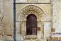
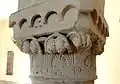
The commune has a number of buildings and structures that are registered as historical monuments:
- A Farmhouse at Puant (1760)
 [10]
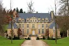
[10] - The Chateau de la Motte (1614 and 1694)[11][12]
- The Park of the Chateau de la Motte (16th century)[13]
- A Farmhouse at la Cour Fontaine (18th century)[14]
- A Farmhouse (1783)[15]
- A House (18th century)[16]
- Houses and Farms (17th to 19th centuries)[17]
- A Manor House (15th century)[18]
Bibliography
- Arcisse de Caumont, Monumental Statistics of Calvados, Ed. Hardel, Caen, 1850, Pages 564-567
See also
External links
- Acqueville on the community of communes website (in French)
- Acqueville on Géoportail, National Geographic Institute (IGN) website (in French)
- Acqueville on the 1750 Cassini Map
Notes and references
Notes
References
- Téléchargement du fichier d'ensemble des populations légales en 2017, INSEE
- Arrêté préfectoral 24 September 2018, p. 124 (in French)
- Inhabitants of Calvados (in French)
- Google Maps
- Albert Dauzat and Charles Rostaing, Etymological Dictionary of place names in France, Ed. Larousse, Paris, 1963 (in French)
- René Lepelley, Etymological Dictionary of commune names in Normandy, Ed. Éditions Charles Corlet, Condé-sur-Noireau, 1996, ISBN 978-2-905461-80-3, Page 45 (in French)
- List of Mayors of France
- Données Cassini, EHESS
- Populations légales 2012, INSEE
- Ministry of Culture, Mérimée IA00000561 Farmhouse at Puant (in French)
- Ministry of Culture, Mérimée PA00111005 Chateau de la Motte (in French)
- Ministry of Culture, Mérimée IA00000554 Chateau de la Motte (in French)

- Ministry of Culture, Mérimée IA14003370 Park of the Chateau de la Motte (in French)
- Ministry of Culture, Mérimée IA00000560 Farmhouse at la Cour Fontaine (in French)
- Ministry of Culture, Mérimée IA00000559 Farmhouse (in French)
- Ministry of Culture, Mérimée IA00000558 House (in French)
- Ministry of Culture, Mérimée IA00000557 Houses and Farms (in French)
- Ministry of Culture, Mérimée IA00000556 Manor House (in French)
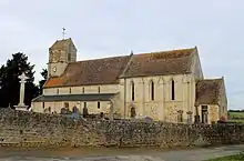
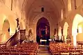
- Ministry of Culture, Mérimée PA00111006 Church of Saint-Aubin (in French)
- Ministry of Culture, Mérimée PA00000553 Church of Saint-Aubin (in French)
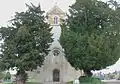
- Ministry of Culture, Mérimée IA00000555 Cemetery Cross (in French)
| Wikimedia Commons has media related to Acqueville (Calvados). |
| Authority control |
|---|