Albright Township, Chatham County, North Carolina
Albright Township, population 2,584, is one of thirteen townships in Chatham County, North Carolina. Albright Township is 52.77 square miles (136.7 km2)[1] in size and located in northwestern Chatham County. Albright Township does not contain any municipalities within it.
Albright Township, Chatham County, North Carolina | |
|---|---|
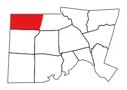 Location of Albright Township in Chatham County | |
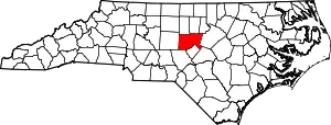 Location of Chatham County in North Carolina | |
| Country | United States |
| State | North Carolina |
| County | Chatham |
| Area | |
| • Total | 52.77 sq mi (136.66 km2) |
| Highest elevation [2] (high point in eastern part of township) | 770 ft (230 m) |
| Lowest elevation [2] (South Fork Cane Creek where it flows north out of the township) | 520 ft (160 m) |
| Population (2010) | |
| • Total | 2,584[3] |
| • Density | 48.97/sq mi (18.91/km2) |
| Time zone | UTC-4 (EST) |
| • Summer (DST) | UTC-5 (EDT) |
| Area code(s) | 704 |
Geography
The Rocky River, a tributary of the Deep River flows through the township and drains the western and southern areas. Tributaries to it include Mud Lick Creek, Greenbriar Creek, West Prong of the Rocky River, and Lacy Creek. South Fork Cane Creek drains the northeastern part of the township.[4]
References
- "NC OneMap". www.nconemap.gov. State of North Carolina. Retrieved 14 October 2020.
- "The National Map - Service Endpoints". viewer.nationalmap.gov. US Geological Survey. Retrieved 18 October 2020.
- "US Census Bureau Populations". data.census.gov. US Census Bureau. Retrieved 19 October 2020.
- "North Carolina Flood Hazard Area Effective". www.nconemap.gov. State of North Carolina. Retrieved 17 October 2020.
Municipalities and communities of Chatham County, North Carolina, United States | ||
|---|---|---|
| Towns |  | |
| CDPs | ||
| Unincorporated communities | ||
| Footnotes | ‡This populated place also has portions in an adjacent county or counties | |
| ||
This article is issued from Wikipedia. The text is licensed under Creative Commons - Attribution - Sharealike. Additional terms may apply for the media files.