Aldan (river)
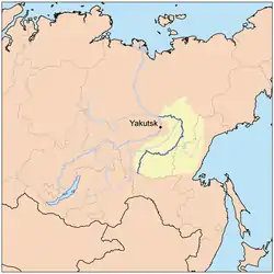
The Aldan (Russian: Алдан) is the second-longest, right tributary of the Lena in the Sakha Republic in eastern Siberia.[1] The river is 2,273 kilometres (1,412 mi) long, of which around 1,600 kilometres (990 mi) is navigable. It has a drainage basin of 729,000 square kilometres (281,000 sq mi).[2] It was part of the River Route to Okhotsk. In 1639 Ivan Moskvitin ascended the rivers Aldan and Maya and crossed to the Ulya to reach the Sea of Okhotsk.
| Aldan | |
|---|---|
 | |
| Location | |
| Country | Russia |
| Physical characteristics | |
| Source | |
| • location | Stanovoy Mountains |
| Mouth | Lena |
• coordinates | 63°26′46″N 129°33′13″E |
| Length | 2,273 km (1,412 mi) |
| Basin size | 729,000 km2 (281,000 sq mi) |
| Discharge | |
| • average | 5,060 m3/s (179,000 cu ft/s) (near mouth) |
| Basin features | |
| Progression | Lena→ Laptev Sea |
| Tributaries | |
| • left | Amedichi, Amga |
| • right | Timpton, Uchur, Maya, Allakh-Yun |
Course
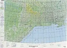
It rises in the Stanovoy Mountains southwest of Neryungri, then flows northeast across the Aldan Highlands past Aldan and through Tommot, Ust-Maya, Eldikan and Khandyga before turning northwest and joining the Lena near Batamay.
The river's main tributaries are the Timpton, Uchur, Maya and Allakh-Yun from the right and the Amga from the left.[1] Its basin is known for gold and for Cambrian fossils.
References
- Zvegintzov, Nicholas; Yates, Anthol (2001). Siberian BAM Guide: Rail, River & Road. Rail Guides Series. Trialblazer Publications. ISBN 9781873756188.
- Алдан (река в Якут. АССР), Great Soviet Encyclopedia
- Река АЛДАН in the State Water Register of Russia (Russian)
| Branches |
| ||||||
|---|---|---|---|---|---|---|---|
| Techniques and tools | |||||||
| Institutions |
| ||||||
| Education |
| ||||||
| |||||||
 | ||
| ||