Aleksandropol Uyezd
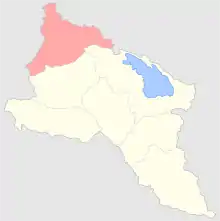
The Aleksandropol Uyezd (Russian: Александропольский уезд; Armenian: Ալեքսանդրապոլի գավառ) was a county of the Erivan Governorate of the Caucasus Viceroyalty of the Russian Empire. It bordered the governorate's Echmiadzinsky and Novobayazetsky Uyezds to the south, the Borchalinsky Uyezd of the Tiflis Governorate to the north and east, the Kazakhsky Uyezd of the Elisabethpol Governorate to the southeast, and the Kars Oblast to the west. It included most of the Shirak Province and southern parts of the Lori Province of present-day northern Armenia. Its administrative center was Aleksandropol (Gyumri).[1]
Aleksandropol Uyezd
Александропольский уезд
| |
|---|---|
.png.webp) Coat of arms | |
 | |
| Country | Russia |
| Political status | Uyezd |
| Region | Caucasus |
| Established | 1849 |
| Abolished | 1918 |
| Area | |
| • Total | 4,278 km2 (1,652 sq mi) |
| Population (1897) | |
| • Total | 165,503 |
| • Density | 39/km2 (100/sq mi) |
Demographics
According to the 1897 Russian Empire Census, the population of the district was 165,503, the overwhelming majority of which were Armenians (85.5%). Minorities included Tatars (modern Azerbaijanis; 4.7%), East Slavs (Russians, Ukrainians, and Belarusians; 4%), Kurds (3%), Greeks (0.6%), and Poles (0.5%).[2] The largest city in the district was Aleksandropol, which had a total population of 30,616, of which 21,771 (71%) were Armenians, 5,157 (16.8%) East Slavs, 1,090 (3.5%) Tatars, 921 (3%) Poles, 415 (1%) Jews, 316 (1%) Lithuanians, and 266 (0.8%) Greeks.[3]
References
- Tsutsiev, Arthur (2014). Atlas of the Ethno-Political History of the Caucasus. Translated by Nora Seligman Favorov. New Haven: Yale University Press. p. 59. ISBN 9780300153088.
- (in Russian) 1897 Census, Aleksandropol Uyezd Demoscope Weekly
- (in Russian) 1897 Census, Aleksandropol City Archived 2014-10-25 at the Wayback Machine Demoscope Weekly
Administrative divisions of the Erivan Governorate | ||
|---|---|---|
Italics indicates abolished uyezds. | ||