Alexander James Kent
Dr Alexander James Kent FBCartS FRGS FSA SFHEA (born 24 August 1977), known as Alex Kent, is a British cartographer, geographer and academic. He is Reader in Cartography and Geographical Information Science at Canterbury Christ Church University and a Senior Research Associate of the Oxford Centre for Islamic Studies at the University of Oxford.

From 2015 to 2017, he served as President of the British Cartographic Society and in 2020, became a Fellow of the Society of Antiquaries and a Senior Fellow of the (UK) Higher Education Academy. Kent has also held fellowships of the Royal Geographical Society since 2006 and of the British Cartographic Society since 2002.
His scholarly contributions have focused upon cartographic aesthetics and topographic mapping, particularly Soviet maps, which led to the publication of The Red Atlas in 2017 (University of Chicago Press).[1] Co-authored with John Davies, the book provided the first general guide to Soviet military mapping - the world's most comprehensive cartographic project of the twentieth century.[2]
Biography
.jpg.webp)
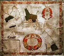
Designing maps, board games and banknotes from an early age, Kent's decision to study cartography at university was largely inspired by a seventeenth-century estate map of Lyminge that used to hang in his father's study as Rector of the parish. After attending Harvey Grammar School in Folkestone, Kent studied for a Joint Honours degree in Geography and Cartography at Oxford Brookes University, which, at the time, was the only university in the UK offering a degree-level qualification in cartography. He then read for a taught MPhil in Geographical Information Systems (GIS) and Remote Sensing at Queens' College, Cambridge, and returned to Oxford Brookes University as a Lecturer in these subjects in 2000. This was combined with voluntary work in the implementation of a GIS for Action Contre la Faim in Colombo, Sri Lanka, and consultancy on the design of Timemaps, an online historical atlas of the world for schools.[3] He also embarked on a long-term cartographic project at the Oxford Centre for Islamic Studies (the Atlas of the Social and Intellectual History of Islam), eventually becoming a Senior Research Associate.
A fascination with the origins of cartographic style and the reasons for its diversity within European state topographic mapping led to a PhD from the University of Kent, supervised by Prof. Peter Vujakovic and Dr Peter Thomas of Canterbury Christ Church University.[4] Using cluster analysis, Kent identified three stylistic groupings within the cartographic symbologies used by national mapping organisations in 20 European countries and noted that the symbologies of Great Britain and Ireland demonstrated the most distinctive stylistic group in Europe (Ireland having been mapped by Britain's Ordnance Survey in 1824). He also interviewed mapping staff in Latvia and Slovenia to discover the extent to which state topographic mapping reflects conditions of political independence. Kent's PhD thesis won the National Geographic Society/British Cartographic Society's New Mapmaker Award for excellence in scholarship in 2007 and an International Cartographic Association (ICA) Travel Award to present the findings at the 23rd International Cartographic Conference in Moscow that year.[5] Subsequently, a paper co-authored with his supervisor Prof. Peter Vujakovic won the 2010 Henry Johns Award for the most outstanding paper published in The Cartographic Journal.[6]
In 2008, Kent became Head of the Cartographic Unit at the School of Geography, University of Southampton and managed a wide range of cartographic projects. As well as a design studio, the Unit offered a large-format printing service and started offering reprints of Soviet maps for sale. The venture was featured as a TV news item on ITV Meridian and BBC South Today.
Kent took up the post of Senior Lecturer in Geography and GIS at Canterbury Christ Church University in 2010 and moved up to his current role as Reader in Cartography and Geographic Information Science in 2015. His recent projects have involved the digital reconstruction of Anglo-Saxon Folkestone for a Heritage Lottery funded project[7] to discover the life of St Eanswythe, a local seventh-century saint, as well as advising on geospatial projects for the UK Commission for UNESCO and on Soviet mapping at the Centre for the Changing Character of War at Pembroke College, Oxford.
A well-known figure in the international cartographic community, Kent has been actively involved in cartographic societies since joining the British Cartographic Society in 2000 and the Society of Cartographers shortly after. He became Editorial Assistant of The Cartographic Journal in 2004 and Editor in 2014. Similarly, he was Editor of The Bulletin of the Society of Cartographers from 2008 to 2015. He served as President of the British Cartographic Society from 2015 to 2017 and founded the World Cartographic Forum, a body within the ICA for leaders of national mapping societies to discuss common issues and share best practice.
The Red Atlas
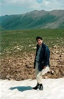
While on a trekking holiday in Central Asia in July 2001, Kent discovered a map retailer in Almaty (the former capital of Kazakhstan) selling stocks of recently de-classified Soviet mapping of the surrounding landscape and of other parts of the world including Salt Lake City and New York City.
On joining the Charles Close Society for the Study of Ordnance Survey Maps he met John Davies, a retired systems analyst based in London who had published a paper in the Society's journal Sheetlines in 2005.[8] Davies and Kent realised that they had uncovered aspects of the same global mapping project from different ends of the former Soviet Union; Davies having discovered stocks of Soviet mapping in Latvia. They embarked on a period of joint research and collaboration with the aim of finding out more about this Cold War project, which they went on to describe as 'the biggest cartographic story never told'.[9]
After publishing a series of academic papers, the Bodleian Library at Oxford invited them to submit a proposal for a short book as an introduction to the subject and eventually offered the project to the University of Chicago Press, who were keen to both expand the book's content and widen its appeal to a US-based audience.
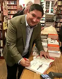
An accumulation of over ten years of original research, The Red Atlas was published in 2017 and met with widespread critical acclaim. Nature called the book a 'glorious homage'[10] and it featured as the Book of the Week in THE, where Jerry Brotton described The Red Atlas as "Brilliant... the best kind of cartographic history".[11] Mark Monmonier praised the book as "carefully researched, well-written, and exquisitely designed and printed, it’s perhaps the only recent map history that can be called a real eye-opener". In 2019, a paperback version of The Red Atlas was published in Japanese by Nikkei National Geographic Inc. Kent gave interviews to several national Japanese newspapers in Tokyo in July that year while attending the 29th International Cartographic Conference.[12]
Davies and Kent's interest in Soviet mapping and its relevance to every place on Earth has generated a number of further publications. They have become acknowledged authorities on the subject and are in high demand as speakers, having presented their research at the Lenin Library in Moscow, the National Geospatial-Intelligence Agency in Washington, DC, the universities of Oxford, Cambridge and Manchester, and at Eton College, where they were invited by the Slavonic Society in 2019. They publish new findings on their website http://www.redatlasbook.com, which is a comprehensive repository of resources associated with Soviet mapping that also provides free-to-view images of the maps and offers reprints for sale.
Martin Davis, one of Kent's PhD students at Canterbury Christ Church University, has researched the holdings of Soviet military city plans in libraries around the world and produced a detailed analysis of the plans' symbology.[13]
In 2021, The Red Atlas was featured by the Map Men in an educational video about Soviet mapping, which became the third highest trending video on YouTube shortly after it was released on 11 January.[14]
Positions and honours
Fellowships
- Fellow of the Society of Antiquaries of London (FSA; 2020)
- Senior Fellow, the UK Higher Education Academy (SFHEA; 2020)
- Fellow of the Royal Geographical Society (FRGS; 2006)
- Fellow of the British Cartographic Society (FBCartS; 2002)
International Roles
- Founding Chair, World Cartographic Forum, International Cartographic Association (since 2017)
- Founding Chair, Commission on Topographic Mapping, International Cartographic Association (since 2015)
- Deputy National Representative (United Kingdom), International Cartographic Association General Assembly (since 2011)
- Vice Chair, Commission on Map Design, International Cartographic Association (2011–2015)
National Roles
- President, British Cartographic Society (2015–2017)
- Editor, The Cartographic Journal (since 2014)
- Vice President, British Cartographic Society (2013–2015)
- Committee Member, Charles Close Society for the Study of Ordnance Survey Maps (since 2008)
- Founder, Ian Mumford Award for excellence in original cartographic research by students, British Cartographic Society (2015)
Awards
- Society of Cartographers Award for an outstanding contribution to the Society of Cartographers (2016)
- Henry Johns Award for the most outstanding paper published in The Cartographic Journal (British Cartographic Society) (2010)
- New Mapmaker Award for excellence in cartographic scholarship (National Geographic Society/British Cartographic Society) (2007)
Selected works
Books
- Mapping Empires: Colonial Cartographies of Land and Sea, Cham: Springer Nature (2019) ISBN 978-3-030-23447-8
- The Red Atlas: How the Soviet Union Secretly Mapped the World, Chicago: University of Chicago Press (2017) ISBN 978-0-226-38957-8
- The Routledge Handbook of Mapping and Cartography, Abingdon: Routledge (2017) ISBN 978-0-367-58104-6
- Landmarks in Mapping: 50 Years of The Cartographic Journal, Leeds: Maney Publishing (2014) ISBN 978-1-909-66238-4
- Cartography: A Reader, Reading: The Society of Cartographers (2014) ISBN 978-0-993-00890-0
- A Celebration of 50 Years of the British Cartographic Society, Ilkeston: British Cartographic Society (2013) ISBN 978-0-904-48224-9
Book Chapters
- "Mapping the Legacy of St Eanswythe" (2020) In Doherty, J., Hardy, L., Richardson, A. and Williams, E. (Eds) Finding Eanswythe: The Life and Afterlife of an Anglo-Saxon Saint Canterbury: Canterbury Christ Church University (pp. 34–37)
- "Red Star to Red Lion: The Soviet Military Mapping of Oxford" (2019) In Kent, A.J., Demhardt, I.J., Vervust, S. and Millea, N. (Eds) Mapping Empires: Colonial Cartographies of Land and Sea, Cham: Springer Nature (pp. 310–313) ISBN 978-3-030-23447-8
- "The Soviet Military Plans of Pembroke and Milford Haven" (2019) In Howell, D.W. (Ed.) An Historical Atlas of Pembrokeshire Haverfordwest: Pembrokeshire County History Trust (pp. 16–17) ISBN 978-1-527-23938-8
- "Foreword" In Darkes, G. and Spence, M. (Eds) Cartography – an introduction (2nd ed.) London: British Cartographic Society (p. 5) ISBN 978-0-904-48225-6
- "Identifying Metadata on Soviet Military Maps: An Illustrated Guide" (2017) In Altic, M., Demhardt, I. and Vervust, S. (Eds) Dissemination of Cartographic Knowledge New York: Springer (pp. 301–313) ISBN 978-3-319-61515-8
- "Cartographic Aesthetics" (2017) "Cartographic Aesthetics" In Kent, A.J. and Vujakovic, P. (Eds) The Routledge Handbook of Mapping and Cartography Abingdon: Routledge (pp. 299–310) ISBN 978-0-367-58104-6
- "Maps and Identity" (2017) In Kent, A.J. and Vujakovic, P. (Eds) The Routledge Handbook of Mapping and Cartography Abingdon: Routledge (pp. 413–426) ISBN 978-0-367-58104-6
- "Cartographic Conventions" (2015) In Monmonier, M. (Ed.) The History of Cartography (Volume VI: The Twentieth Century) Chicago: University of Chicago Press (pp. 273–278) ISBN 978-0-226-53469-5
- "Reproduction, Design and Aesthetics" (2015) In Monmonier, M. (Ed.) The History of Cartography (Volume VI: The Twentieth Century) Chicago: University of Chicago Press (pp. 1331–1336) ISBN 978-0-226-53469-5
Papers and Editorials
- Kent, A.J. (2020) "Mapping and Counter-mapping COVID-19: From Crisis to Cartocracy" The Cartographic Journal 57 (3) pp. 187–195 DOI:10.1080/00087041.2019.1660513
- Kent, A.J. (2020) "All that Glitters: Art, Fire and Post-Cartographic Design" The Cartographic Journal 57 (1) pp. 1–5 DOI:10.1080/00087041.2020.1735085
- Kent, A.J. and Davies, J. (2020) "The Secret Soviet Mapping of Malta" Imago Melitae (10 years of the Malta Map Society) pp. 23–30 PDF (ResearchGate)
- Kent, A.J., Vujakovic, P., Eades, G. and Davis, M. (2020) "Putting the UN SDGs on the Map: The Role of Cartography in Sustainability Education" The Cartographic Journal 57 (2) pp. 93–96 DOI:10.1080/00087041.2020.1770424
- Davies, J. and Kent, A.J. (2019) "Secret Soviet Maps" Land - Journal of the Royal Institute of Chartered Surveyors (RICS) (July) pp. 6–8 PDF (issuu)
- Kent, A.J. (2019) "A Picture and an Argument: Mapping for Peace with a Cartography of Hope" The Cartographic Journal 56 (4) pp. 275–279 DOI:10.1080/00087041.2019.1694804
- Kent, A.J. (2019) "Maps, Materiality and Tactile Aesthetics" The Cartographic Journal 56 (1) pp. 1–3 DOI:10.1080/00087041.2019.1601932
- Kent, A.J., Davis, M. and Davies, J. (2019) "The Soviet Mapping of Poland – A Brief Overview" Miscellanea Geographica – Regional Studies on Development 23 (1) pp. 1–11 DOI:10.2478/mgrsd-2018-0034
- Kent, A.J. (2019) "The Wondermaps of Max Gill" The Ephemerist 184 (Spring) pp. 12–19 PDF (ResearchGate)
- Kent, A.J. (2018) "Form Follows Feedback: Rethinking Cartographic Communication" Westminster Papers in Communication and Culture 13 (2) pp. 96–112 DOI:10.16997/wpcc.296
- Kent, A.J. and Hopfstock, A. (2018) "How Topographic Maps Affect: Experiencing Washington, DC Through the Maps of the ‘Other’" Cartographic Perspectives 91 pp.81–95 DOI:10.14714/CP91.1459
- Kent, A.J. and Hopfstock, A. (2018) "Topographic Mapping: Past, Present and Future" The Cartographic Journal 55 (4) pp. 305–306 DOI:10.1080/00087041.2018.1576973
- Davis, M. and Kent, A.J. (2017) "Improving User Access to Soviet Military Mapping: Current Issues in Libraries and Collections Around the Globe" Journal of Map and Geography Libraries 13 (2) pp. 246–260 DOI:10.1080/15420353.2017.1300206
- Field, K. and Kent, A.J. (2015) "Fifty Years of The Cartographic Journal" The Cartographic Journal 52 (3) pp. 228–231 DOI:10.1080/00087041.2015.1119942
- Kent, A.J. (2014) "A Profession Less Ordinary? Reflections on the Life, Death and Resurrection of Cartography" The Bulletin of the Society of Cartographers 48 (1,2) pp. 7–16 PDF (ResearchGate)
- Kent, A.J. (2014) "Thomas Hill’s Map of Lyminge, 1685" Lyminge: A History 6 (23) pp. 1–13 PDF (ResearchGate)
- Kent, A.J. (2013) "From a Dry Statement of Facts to a Thing of Beauty: Understanding Aesthetics in the Mapping and Counter-mapping of Place" Cartographic Perspectives 73 pp. 39–60 DOI:10.14714/CP73.592
- Kent, A.J. (2013) "Understanding Aesthetics: The Cartographers’ Response" The Bulletin of the Society of Cartographers 46 (1,2) pp. 31–43 PDF (ResearchGate)
- Kent, A.J., Field, K., Jenny, B. and Hopfstock, A. (2013) "Cartographic Design and Aesthetics ‘FAQ’" Cartographic Perspectives 73 pp.1–4 DOI:10.14714/CP73.594
- Kent, A.J. and Davies, J. (2013) "Hot Geospatial Intelligence from a Cold War: The Soviet Military Mapping of Towns and Cities" Cartography and Geographic Information Science 40 (3) pp. 248–253 DOI:10.1080/15230406.2013.799734
- Kent, A.J. and Vujakovic, P. (2011) "Cartographic Language: Towards a New Paradigm for Understanding Stylistic Diversity in Topographic Maps" The Cartographic Journal 48 (1) pp. 21–40 DOI:10.1179/1743277411Y.0000000004
- Kent, A.J. (2011) "Helping Haiti: Some Reflections on Contributing to a Global Disaster Relief Effort" The Bulletin of the Society of Cartographers 44 (1,2) pp. 39–45 PDF (ResearchGate)
- Kent, A.J. (2009) "Cartographic Blandscapes and the New Noise: Finding the Good View in a Topographical Mashup" The Bulletin of the Society of Cartographers 42 (1,2) pp. 29–37 PDF (ResearchGate)
- Kent, A.J. (2009) "Topographic Maps: Methodological Approaches for Analyzing Cartographic Style" Journal of Map and Geography Libraries 5 (2) pp. 131–156 DOI:10.1080/15420350903001187
- Kent, A.J. and Vujakovic, P. (2009) "Stylistic Diversity in European State 1:50 000 Topographic Maps" The Cartographic Journal 46 (3) pp. 179–213 DOI:10.1179/000870409X12488753453453
- Kent, A.J. (2005) "Aesthetics: A Lost Cause in Cartographic Theory?" The Cartographic Journal 42 (2) pp. 182–188 DOI:10.1179/000870405X61487
Expert Comments and Blogs
- "Apple, Maps and the Localisation of Fact" (2019) Canterbury Christ Church University Expert Comment
- "And the Band Played On: 30 Years After the Deal Bombing" (2019) Canterbury Christ Church University Expert Comment
- "Boxit: Remapping the Shetland Islands" (2018) Canterbury Christ Church University Expert Comment
- "From Sevastopol to Salisbury: Are we at Cold War 2.0?" (2018) Canterbury Christ Church University Expert Comment
- "5 Reasons why Soviet Maps are Amazing" (with John Davies, 2018) Stanfords Blog
- "Banksy, Brexit and the Star of Dover" (2017) Canterbury Christ Church University Expert Comment
- "Farewell to the Azure Window" (2017) Canterbury Christ Church University Expert Comment
- "Cartography and the Kuznetsov" (with Martin Davis, 2016) Canterbury Christ Church University Expert Comment
- "Mapping Poverty" (with John Hills, 2016) Canterbury Christ Church University Expert Comment
- "Propaganda Mapping and Brexit" (2016) Canterbury Christ Church University Expert Comment
References
- "The Red Atlas". University of Chicago Press Books.
- Kent, Alexander James; Davis, Martin; Davies, John. "The Soviet Mapping of Poland - A Brief Overview". Miscellanea Geographica. 23 (1): 5–15. doi:10.2478/mgrsd-2018-0034. Retrieved 26 December 2020.
- "Timemaps". Timemaps Homepage. Retrieved 22 December 2020.
- Kent, Alexander James (31 March 2007). An Analysis of the Cartographic Language of European State Topographic Maps: Aesthetics, Style, and Identity. Retrieved 22 December 2020.
- "ICC2017". International Cartographic Association. Retrieved 30 December 2020.
- Kent, Alexander James; Vujakovic, Peter (2009). "Stylistic Diversity in". The Cartographic Journal. 46 (3): 179–213. doi:10.1179/000870409X12488753453453. Retrieved 22 December 2020.
- "Finding Eanswythe". Finding Eanswythe Homepage. Retrieved 30 December 2020.
- Davies, John (2005). "Uncle Joe Knew Where You Lived: The Story of Soviet Mapping of the UK (Part 1)" (PDF). Sheetlines. 72: 26–38. Retrieved 30 December 2020.
- Davies, John; Kent, Alexander James. "5 Reasons Why Soviet Maps Are Amazing". Stanfords Blog. Retrieved 30 December 2020.
- Kiser, Barbara (12 October 2017). "The Red Atlas (Review)". Nature. 550 (187). Retrieved 30 December 2020.
- Brotton, Jerry (7 December 2017). "The Red Atlas: How the Soviet Union Secretly Mapped the World, by John Davies and Alexander J. Kent". The Times Higher Education Supplement. The Times. Retrieved 30 December 2020.
- "ICC2019". International Cartographic Association. Retrieved 30 December 2020.
- Davis, Martin (2018). A cartographic analysis of Soviet Military city plans (PhD Thesis ed.). Canterbury: Canterbury Christ Church University. Retrieved 30 December 2020.
- Foreman, Jay; Cooper-Jones, Mark. "Why does Russia have the best maps of Britain?". YouTube. Retrieved 15 January 2021.