Amnicon River
The Amnicon River is a 45.5-mile (73.2 km)[2] river in Douglas County, Wisconsin. The river's source is east of Dowling Lake and Amnicon Lake in central Douglas County, and its mouth is at Lake Superior east of Superior.
| Amnicon River | |
|---|---|
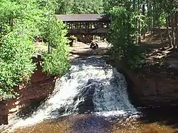 Lower Falls in Amnicon Falls State Park | |
| Location | |
| Country | United States |
| Location | Douglas County, Wisconsin |
| Physical characteristics | |
| Source | |
| • location | East of Dowling Lake |
| • coordinates | 46.473957°N 92.03194°W |
| • elevation | 600 ft (180 m) |
| Mouth | |
• location | Lake Superior |
• coordinates | 46.691884°N 91.858243°W |
| Length | 45.5 mi (73.2 km) |
| Basin features | |
| GNIS ID | 1560841[1] |
Amnicon Falls State Park includes two major waterfalls along the river. The two waterfalls highlight the Douglas Fault, which separates basalt and sandstone formations in the area. The Upper Falls flow over basalt, while the Lower Falls flow over sandstone.[3]
In the nineteenth century, loggers used the river to transport logs to Lake Superior. These logging operations provided building materials for Superior and Duluth, both new towns at the time.[4]
References
- "Amnicon River". Geographic Names Information System. United States Geological Survey.
- U.S. Geological Survey. National Hydrography Dataset high-resolution flowline data. The National Map
- "Amnicon Falls State Park Geology". Wisconsin Department of Natural Resources. Retrieved September 14, 2019.
- "Amnicon Falls State Park History". Wisconsin Department of Natural Resources. Retrieved September 14, 2019.
This article is issued from Wikipedia. The text is licensed under Creative Commons - Attribution - Sharealike. Additional terms may apply for the media files.