Andersson Peak
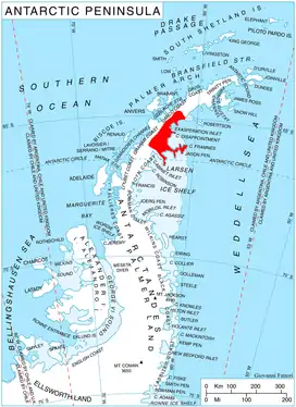
Andersson Peak (64°52′S 61°2′W) is an ice-capped peak, 1,230 metres (4,040 ft) high, with rocky exposures on its east side, lying 9 nautical miles (17 km) north of Cape Fairweather and 5 miles (8.0 km) west of Tashukov Nunatak on the east coast of Graham Land, Antarctica. It was charted in 1947 by the Falkland Islands Dependencies Survey, and named by them for Karl Andreas Andersson, a zoologist with the Swedish Antarctic Expedition, who had explored along this coast in 1902.[1]

Location of Oscar II Coast on Antarctic Peninsula.
See also
References
- "Andersson Peak". Geographic Names Information System. United States Geological Survey. Retrieved 2011-05-10.
![]() This article incorporates public domain material from the United States Geological Survey document: "Andersson Peak". (content from the Geographic Names Information System)
This article incorporates public domain material from the United States Geological Survey document: "Andersson Peak". (content from the Geographic Names Information System)
This article is issued from Wikipedia. The text is licensed under Creative Commons - Attribution - Sharealike. Additional terms may apply for the media files.