Antrain
Antrain (Gallo: Antrein) is a former commune in the Ille-et-Vilaine department in the Brittany in northwestern France. On 1 January 2019, it was merged into the new commune Val-Couesnon.[2] Château de Bonnefontaine dates to the second quarter of the 16th century.[3]
Antrain | |
|---|---|
Part of Val-Couesnon | |
_Mairie_01.jpg.webp) Town hall | |
.svg.png.webp) Coat of arms | |
Location of Antrain 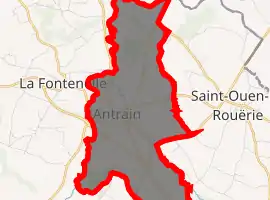
| |
 Antrain 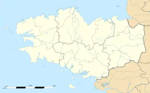 Antrain | |
| Coordinates: 48°27′40″N 1°29′01″W | |
| Country | France |
| Region | Brittany |
| Department | Ille-et-Vilaine |
| Arrondissement | Fougères-Vitré |
| Canton | Antrain |
| Commune | Val-Couesnon |
| Area 1 | 9.31 km2 (3.59 sq mi) |
| Population (2017)[1] | 1,302 |
| • Density | 140/km2 (360/sq mi) |
| Time zone | UTC+01:00 (CET) |
| • Summer (DST) | UTC+02:00 (CEST) |
| Postal code | 35560 |
| Elevation | 6–84 m (20–276 ft) |
| 1 French Land Register data, which excludes lakes, ponds, glaciers > 1 km2 (0.386 sq mi or 247 acres) and river estuaries. | |
Population
| Year | Pop. | ±% |
|---|---|---|
| 1794 | 1,522 | — |
| 1798 | 1,419 | −6.8% |
| 1800 | 1,375 | −3.1% |
| 1804 | 1,543 | +12.2% |
| 1806 | 1,527 | −1.0% |
| 1820 | 1,524 | −0.2% |
| 1826 | 1,633 | +7.2% |
| 1831 | 1,742 | +6.7% |
| 1836 | 1,651 | −5.2% |
| 1841 | 1,567 | −5.1% |
| 1846 | 1,648 | +5.2% |
| 1851 | 1,696 | +2.9% |
| 1856 | 1,613 | −4.9% |
| 1861 | 2,262 | +40.2% |
| 1866 | 1,642 | −27.4% |
| 1872 | 1,630 | −0.7% |
| 1876 | 1,582 | −2.9% |
| 1881 | 1,601 | +1.2% |
| 1886 | 1,525 | −4.7% |
| 1891 | 1,575 | +3.3% |
| 1896 | 1,550 | −1.6% |
| 1906 | 1,443 | −6.9% |
| 1911 | 1,552 | +7.6% |
| 1921 | 1,484 | −4.4% |
| 1926 | 1,417 | −4.5% |
| 1931 | 1,383 | −2.4% |
| 1936 | 1,459 | +5.5% |
| 1946 | 1,682 | +15.3% |
| 1954 | 1,528 | −9.2% |
| 1962 | 1,444 | −5.5% |
| 1968 | 1,443 | −0.1% |
| 1975 | 1,548 | +7.3% |
| 1982 | 1,499 | −3.2% |
| 1990 | 1,387 | −7.5% |
| 1999 | 1,387 | +0.0% |
| 2007 | 1,426 | +2.8% |
| 2017 | 1,302 | −8.7% |
Inhabitants of Antrain are called Antrenais in French.
References
- Téléchargement du fichier d'ensemble des populations légales en 2017, INSEE
- Arrêté préfectoral 28 September 2018 (in French)
- "Château de Bonnefontaine" (in French). Monumentum.fr. Retrieved 28 April 2015.
External links
| Wikimedia Commons has media related to Antrain. |
- Base Mérimée: Search for heritage in the commune, Ministère français de la Culture. (in French)
| Authority control |
|---|
This article is issued from Wikipedia. The text is licensed under Creative Commons - Attribution - Sharealike. Additional terms may apply for the media files.