Arcachon Bay
Arcachon Bay (French: Bassin d'Arcachon) is a bay of the Atlantic Ocean on the southwest coast of France, situated in Pays de Buch between the Côte d'Argent and the Côte des Landes, in the region of Aquitaine. The bay covers an area of 150 km² at high tide and 40 km² at low tide. Some of its geological features are natural preservation areas.[2]
| Designations | |
|---|---|
| Official name | Bassin d'Arcachon - Secteur du delta de l'Eyre |
| Designated | 27 October 2011 |
| Reference no. | 1996[1] |
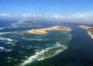
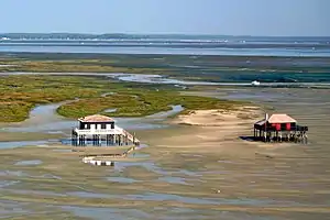
The general shape of the Bassin d'Arcachon is that of an equilateral triangle pointing north, the southwest corner of which is open to the sea, between Cap Ferret and the town of Arcachon (more specifically, one of the suburbs of La Teste-de-Buch, Pyla-sur-Mer), through a 3 km narrow channel (Les Passes). On the north shore is the town of Arès, then Andernos-les-Bains on the northeast. Just south of the entrance is The Great Dune of Pyla. Nearly in the middle of the bay is a very particular island: L'île aux Oiseaux (Isle of the Birds).[2]
Development

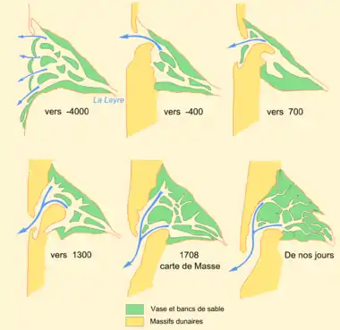
In the past, similar areas became lakes (called in French lacs or étangs) and are nowadays filled with fresh water. On the French Atlantic coast, running north–south between the Gironde estuary to the Adour river mouth, are the Lac d'Hourtin-Carcans, the Lac de Lacanau, the Étang de Cazaux et de Sanguinet, the Étang de Biscarrosse et de Parentis, the Étang d'Aureilhan, the Étang de Léon, the Étang de Soustons, the Étang Hardy, the Étang Blanc and the Étang de Garros. Arcachon Bay is the last water area that remains open to the ocean.[2]
The Bassin still has a link to the sea perhaps because of the Eyre River that runs from the Landes forest and has its mouth (Delta de l'Eyre) in its southeast corner. Otherwise the Bassin would have become blocked by the sandbanks built up by the tides.[2]
References
- "Bassin d'Arcachon - Secteur du delta de la Leyre". Ramsar Sites Information Service. Retrieved 25 April 2018.
- Nicola Williams, Oliver Berry, Stuart Butler, Jean-Bernard Carillet, Kerry Christiani, Gregor Clark, Emilie Filou, Catherine Le Nevez & Daniel Robinson (2015). Lonely Planet France (Travel Guide) Paperback – 13 Mar 2015 by Lonely Planet.
| Wikimedia Commons has media related to Arcachon Bay. |