Asperjoc
Asperjoc is a former commune in the Ardèche department in the Auvergne-Rhône-Alpes region of southern France. On 1 January 2019, it was merged into the new commune Vallées-d'Antraigues-Asperjoc.[2]
Asperjoc | |
|---|---|
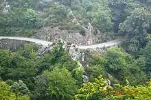
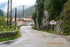 The entry to Laulagnet | |
Location of Asperjoc 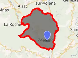
| |
 Asperjoc  Asperjoc | |
| Coordinates: 44°41′09″N 4°21′35″E | |
| Country | France |
| Region | Auvergne-Rhône-Alpes |
| Department | Ardèche |
| Arrondissement | Largentière |
| Canton | Aubenas-1 |
| Area 1 | 8.47 km2 (3.27 sq mi) |
| Population (2017)[1] | 404 |
| • Density | 48/km2 (120/sq mi) |
| Time zone | UTC+01:00 (CET) |
| • Summer (DST) | UTC+02:00 (CEST) |
| INSEE/Postal code | 07016 /07600 |
| Elevation | 278–879 m (912–2,884 ft) (avg. 299 m or 981 ft) |
| 1 French Land Register data, which excludes lakes, ponds, glaciers > 1 km2 (0.386 sq mi or 247 acres) and river estuaries. | |
The inhabitants of the commune are known as Asperjocois.[3]
Geography
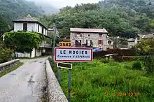
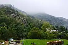
Asperjoc is located some 2 km north by north-west of Aubenas and 18 km west by south-west of Privas. Access to the commune is by the D 578 road from Antraigues-sur-Volane in the north which passes down the eastern border of the commune and continues south to Vals-les-Bains. The D 243 branches off the D 578 in the south of the commune and goes north-west through the commune and continues to Labastide-sur-Bésorgues. The commune has no village called Asperjoc but has several hamlets: les Beaumelles, la Brugeyre, le Chastelas, le Fau, Laulagnet, le Pont de Bridou, le Pont de l-Huile, la Praye, le Raccourci, le Rigaudel, Thieure, Tras Chabanne et la Valette inférieure. The commune is rugged and alpine in nature with little or no arable land.[4]
The Volane river forms the entire eastern border of the commune as it flows south to join the Ardèche south of Vals-les-Bains. The Besorgues flows from the north-west of the commune south-east forming part of the western border of the commune and gathering many tributaries in the commune before joining the Volane at the southern corner.[4]
Neighbouring communes and villages
Places adjacent to Asperjoc | |
|---|---|
Administration
List of Successive Mayors[5]
| From | To | Name | Party | Position |
|---|---|---|---|---|
| 2001 | 2008 | Louis Berthon | ||
| 2008 | 2019 | Alain Chiraussel |
(Not all data is known)
Demography
In 2012 the commune had 418 inhabitants.
|
| |||||||||||||||||||||||||||||||||||||||||||||||||||||||||||||||||||||||||||||||||||||||||||||||||||||||||||||||
| Source: EHESS[6] and INSEE[7] | ||||||||||||||||||||||||||||||||||||||||||||||||||||||||||||||||||||||||||||||||||||||||||||||||||||||||||||||||
Distribution of Age Groups
The population of the town is relatively old. The ratio of persons above the age of 60 years (22.3%) is higher than the national average (21.6%) but lower than the departmental average (28.1%). As for national and departmental allocations, the male population of the town is less than the female population (48.8% against 48.4% nationally and 48.2% at the departmental level).
Percentage Distribution of Age Groups in Asperjoc and Ardèche Department in 2010
| Asperjoc | Asperjoc | Ardèche | Ardèche | |
|---|---|---|---|---|
| Age Range | Men | Women | Men | Women |
| 0 to 14 Years | 19.0 | 17.6 | 18.6 | 16.8 |
| 15 to 29 Years | 13.8 | 15.7 | 15.3 | 13.9 |
| 30 to 44 Years | 24.8 | 17.1 | 19.4 | 18.5 |
| 45 to 59 Years | 20.5 | 21.9 | 21.5 | 20.6 |
| 60 to 74 Years | 16.2 | 18.1 | 16.5 | 16.8 |
| 75 to 89 Years | 5.7 | 9.0 | 8.1 | 11.9 |
| 90 Years+ | 0.0 | 0.5 | 0.5 | 1.5 |
Sources:
Sites and monuments
- Church from the 19th century
- La Chaise du Diable waterfall
See also
References
- Téléchargement du fichier d'ensemble des populations légales en 2017, INSEE
- Arrêté préfectoral 29 October 2018 (in French)
- Inhabitants of Ardèche (in French)
- Google Maps
- List of Mayors of France (in French)
- Données Cassini, EHESS
- Populations légales 2012, INSEE
External links
| Wikimedia Commons has media related to Asperjoc. |
- Asperjoc on the old IGN website (in French)
- Asperjoc on Lion1906
- Asperjoc on Géoportail, National Geographic Institute (IGN) website (in French)
- Asprejoc on the 1750 Cassini Map