Auenheim
Auenheim is a former commune in the Bas-Rhin department in the Grand Est region of north-eastern France. On 1 January 2019, it was merged into the new commune Rountzenheim-Auenheim.[2]
Auenheim | |
|---|---|
Part of Rountzenheim-Auenheim | |
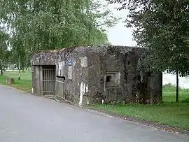 Blockhouse 1 in Auenheim | |
.svg.png.webp) Coat of arms | |
Location of Auenheim 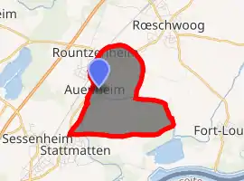
| |
 Auenheim  Auenheim | |
| Coordinates: 48°48′44″N 8°00′38″E | |
| Country | France |
| Region | Grand Est |
| Department | Bas-Rhin |
| Arrondissement | Haguenau-Wissembourg |
| Canton | Bischwiller |
| Commune | Rountzenheim-Auenheim |
| Area 1 | 4.24 km2 (1.64 sq mi) |
| Population (2017)[1] | 900 |
| • Density | 210/km2 (550/sq mi) |
| Time zone | UTC+01:00 (CET) |
| • Summer (DST) | UTC+02:00 (CEST) |
| Postal code | 67480 |
| Elevation | 116–121 m (381–397 ft) |
| 1 French Land Register data, which excludes lakes, ponds, glaciers > 1 km2 (0.386 sq mi or 247 acres) and river estuaries. | |
The inhabitants of the commune are known as Auenheimois or Auenheimoises.[3]
Geography
Auenheim is located some 15 km east of Haguenau and 13 km north-east of Bischwiller. Access to the commune is by the road D468 from Rœschwoog in the north-east which passes through the north of the commune and the village before continuing to Stattmatten in the south. The D463 branches off the D468 in the north of the commune and goes west to Rountzenheim. The TER Strasbourg-Lauterbourg railway passes through the village and there is a station in the commune which, however, appears to be disused. There is a belt of forest through the centre of the commune (the Biergrund) and a large forest in the south-east of the commune (the Unterwald) with substantial urbanisation in the north-west of the commune with the rest farmland.[4]
The Moder river comes from the south and passes through the south-west then the centre of the commune before forming half of the eastern border and continuing east to join the Rhine at Neuhaeusel. There is also a large reservoir in the north of the commune.[4]
Neighbouring communes and villages
Places adjacent to Auenheim | |
|---|---|
Toponymy
According to the Cassini Map of 1750 Auen- was spelt Augenheim which in modern German would mean "of the eye" + -heim meaning "hamlet or village".
The suffix -heim indicates a Frankish origin since before the first creation of villages by the Alemanni. -heim signified a "hamlet" or a group of houses in French from which came the Alemannic hüs from which comes haus which is "house" in German.
In 1359 the village was called Oweheim and in 1596 it was Awenheim.
Heraldry
Arms of Auenheim |
Blazon: Argent, a Roman letter M surmounted by a crossette paty and between three crossettes at dexter, sinister and base all in Sable. |
Administration
List of Successive Mayors[5]
| From | To | Name | Party | Position |
|---|---|---|---|---|
| 2001 | 2020 | Joseph Ludwig |
(Not all data is known)
Demography
In 2012 the commune had 898 inhabitants.
|
| |||||||||||||||||||||||||||||||||||||||||||||||||||||||||||||||||||||||||||||||||||||||||||||||||||||||||||||||
| Source: EHESS[6] and INSEE[7] | ||||||||||||||||||||||||||||||||||||||||||||||||||||||||||||||||||||||||||||||||||||||||||||||||||||||||||||||||
Culture and heritage
Civil heritage
The commune has a number of buildings and sites that are registered as historical monuments:
- A House at 1 Rue de l'Eglise (17th century)
 [8]
[8] - A Farmhouse at 2 Rue des Oies (1930)[9]
- The Town Hall and School at Rue principale (1850)[10]
- A Farmhouse at 23 Rue principale (1822)[11]
- A Farmhouse at 24 Rue principale (18th century)[12]
- A House at 45 Rue principale (18th century)[13]
- A Farmhouse at 47 Rue principale (18th century)[14]
- Houses and Farms[15]
One structure is registered as an historical object:
- The War Memorial (20th century)
 [16]
[16]
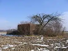
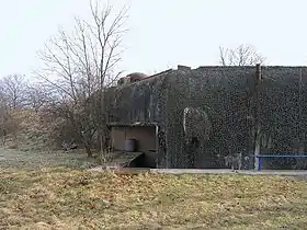
The Maginot Line
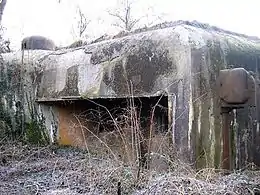
- Auenheim Blockhouse north
An isolated infantry Blockhouse, simple flank built in 1932. It housed an officer, a non-commissioned officer and 20 enlisted men.
- Floor dimensions: 25x15 metres;
- Height: 7.50 metres;
- Thickness of structural work: 2 metres;
- Exposed concrete slab: 2.25m thick walls;
- Rear walls: 1 m thick.
- Armament: one 37mm Cannon, 3 Reibel machine guns, 5 FM, 2 50 mm mortars, grenade launcher chutes.
- History: From 1939 to 1940 the blockhouse was held by a detachment of the 68th Fortress Infantry Regiment who resisted German pressure until 1 July 1940, 6 days after the Armistice came into effect (25 June 1940).
- Auenheim Blockhouse south
An isolated infantry Blockhouse, simple flank built in 1932. It housed an officer, a non-commissioned officer and 20 enlisted men.
- Floor dimensions: 25x15 metres;
- Height: 7.50 metres;
- Thickness of structural work: 2 metres;
- Exposed concrete slab: 2.25m thick walls;
- Rear walls: 1 m thick.
- Armament: one 37mm Cannon, 3 Reibel machine guns, 5 FM, 2 50 mm mortars, grenade launcher chutes.
- History: From 1939 to 1940 the blockhouse was held by a detachment of the 68th Fortress Infantry Regiment who resisted German pressure until 1 July 1940, 6 days after the Armistice came into effect (25 June 1940).
- Blockhouse 1
- 1 25mm antitank gun, 1 Hotchkiss machine gun
- Blockhouse 2
- 1 25mm antitank gun.
- Blockhouse 3
- 1 25mm antitank gun.
Notable people linked to the commune
- Henri Loux, born at Auenheim in 1873 and died at Strasbourg in 1907. An illustrator of the countryside and village scenes on a range of tableware called "Obernai".
See also
References
- Téléchargement du fichier d'ensemble des populations légales en 2017, INSEE
- Arrêté préfectoral 4 September 2018 (in French)
- Inhabitants of Bas-Rhin (in French)
- Google Maps
- List of Mayors of France (in French)
- Données Cassini, EHESS
- Populations légales 2012, INSEE
- Ministry of Culture, Mérimée IA00124076 House at 1 Rue de l'Eglise (in French)
- Ministry of Culture, Mérimée IA00124078 Farmhouse at 2 Rue des Oies (in French)
- Ministry of Culture, Mérimée IA00124075 Town Hall and School (in French)
- Ministry of Culture, Mérimée IA00124079 Farmhouse at 23 Rue principale (in French)
- Ministry of Culture, Mérimée IA00124080 Farmhouse at 24 Rue principale (in French)
- Ministry of Culture, Mérimée IA00124077 House at 45 Rue principale (in French)
- Ministry of Culture, Mérimée IA00124081 Farmhouse at 47 Rue principale (in French)
- Ministry of Culture, Mérimée IA00124184 Houses and Farms (in French)
- Ministry of Culture, Palissy IM67007268 War Memorial (in French)
- Ministry of Culture, Mérimée IA00124074 Cemetery (in French)
- Ministry of Culture, Palissy IM67007263 Movable objects in the Cemetery (in French)
- Ministry of Culture, Palissy IM67007188 Tomb of Hélène Kuhry (in French)