Březové Hory
Březové Hory (Czech also: Příbram VI - Březové Hory or Příbram - Březové Hory, German: Birkenberg) is a district (Příbram VI - Březové Hory) in Příbram, Czech republic. The Litavka flows along the border with Podlesí village. There are 1323 permanent residents as of 2001.[1]
Březové Hory | |
|---|---|
district of Příbram | |
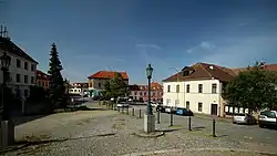 J. A. Alis square | |
 Březové Hory Location in the Czech Republic | |
| Coordinates: 49°41′18″N 13°59′25″E | |
| Country | Czech Republic |
| Region | Central Bohemian |
| District | Příbram |
| First mentioned | 1300 |
| Town privileges | 1896 |
| Area | |
| • Total | 16.8 km2 (6.5 sq mi) |
| Population (2001-01-01) | |
| • Total | 1,323 |
| • Density | 79/km2 (200/sq mi) |
| Time zone | UTC+1 (CET) |
| • Summer (DST) | UTC+2 (CEST) |
| Postal code | 261 02 |
History
The first evidence of silver mining in Březové Hory dates from the 14th century. At the beginning of the 16th century a mining settlement was established near the silver-ore mines, it was promoted to a township in the 18th century. It reached its greatest fame at the turn of the 18th and 19th centuries, when five underground mines were gradually open. The volume of mined silver then reached up to 97% of all mined silver in the Austro-Hungarian monarchy and Březové Hory became the main silver producer in Europe. This is one of the reasons why the town was promoted to a royal mining town on 20 April 1896 by Emperor Franz Joseph I.
Since the beginning of the 20th century there has been a gradual decline in mining, but thanks to the state subsidies mining continued until 1978. After mining was terminated, several mining buildings were converted to Příbram mining museum . It is currently the largest mining museum in the Czech Republic.
In 1953 Březové Hory became part of Příbram.
Cultural Monuments
In the Březové Hory area there are many preserved mines and other buildings designated as the Czech cultural monuments, some of them are on the national cultural monument list.
- Miner's House (Czech: Hornický domek)[2]
- Portal of Ševčiny transportation adit (Czech: Portál Ševčinské štoly)[3] - national cultural monument
- Portal of Marie transportation adit (Czech: Portál Mariánské štoly)[4] - national cultural monument
- Mining Inspectorate (Czech: Báňský inspektorát)[5]
- Administrative building- Mine engineering (Czech: Důlní projekce)[6]
- St. Prokop Church (Czech: Kostel sv. Prokopa)[7]
- Mining office building (Czech: Úřednický dům also called Šichtamt)[8]
- Ševčiny Mine (Czech: Důl Ševčiny)[9] - national cultural monument
- Anna Mine (Czech: Důl Anna)[10] - national cultural monument
- Adalbert Mine (Czech: Důl Vojtěch)[11] - national cultural monument
- St. Adalbert Church (Czech: Kostel sv. Vojtěcha)[12]
Gallery
- Cultural monuments in the Březové Hory area
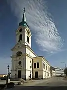 St. Adalbert Church
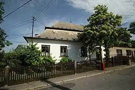 Admin building "Šichtamt"
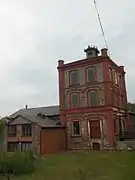 Adalbert mine
_-_d%C5%AFl_Anna_(2).jpg.webp) Anna Mine
Anna Mine.jpg.webp) Ševčiny Mine
Ševčiny Mine.jpg.webp) Portal of Ševčiny Adit
Portal of Ševčiny Adit_-_budova_d%C5%AFln%C3%AD_projekce_%C4%8Dp._31_(2).jpg.webp) Engineering Building
Engineering Building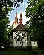 St. Prokop Church
_-_budova_b%C3%A1%C5%88sk%C3%A9ho_inspektor%C3%A1tu_%C4%8Dp._257_(1).jpg.webp) Mine Inspection Building
Mine Inspection Building
References
- Počet obyvatel dle sčítání lidu, domů a bytů podle databáze ČSÚ 2001
- "hornický domek - Památkový Katalog". www.pamatkovykatalog.cz. Retrieved 2019-10-02.
- "portál Ševčinské štoly - Památkový Katalog". www.pamatkovykatalog.cz. Retrieved 2019-10-02.
- "portál Mariánské štoly - Památkový Katalog". www.pamatkovykatalog.cz. Retrieved 2019-10-02.
- "báňský inspektorát - Památkový Katalog". www.pamatkovykatalog.cz. Retrieved 2019-10-02.
- "důlní projekce - Památkový Katalog". www.pamatkovykatalog.cz. Retrieved 2019-10-02.
- "kostel sv. Prokopa - Památkový Katalog". www.pamatkovykatalog.cz. Retrieved 2019-10-02.
- "úřednický dům zv. Šichtamt - Památkový Katalog". www.pamatkovykatalog.cz. Retrieved 2019-10-02.
- "rudný důl Ševčiny - Památkový Katalog". www.pamatkovykatalog.cz. Retrieved 2019-10-02.
- "rudný důl Anna - Památkový Katalog". www.pamatkovykatalog.cz. Retrieved 2019-10-02.
- "rudný důl Vojtěch - Památkový Katalog". www.pamatkovykatalog.cz. Retrieved 2019-10-02.
- "kostel sv. Vojtěcha - Památkový Katalog". www.pamatkovykatalog.cz. Retrieved 2019-10-02.