Balder Point
Balder Point (66°27′S 63°45′W) is a headland in Antarctica marking the eastern tip of a narrow, rocky "cockscomb" ridge, which extends from Frigga Peak for 6 nautical miles (11 km) in an east-southeast direction to the west side of Cabinet Inlet, on the east coast of Graham Land. It was charted in 1947 by the Falkland Islands Dependencies Survey, who named it after the Norse god Balder, the mythological son of Frigga and Odin.[1]
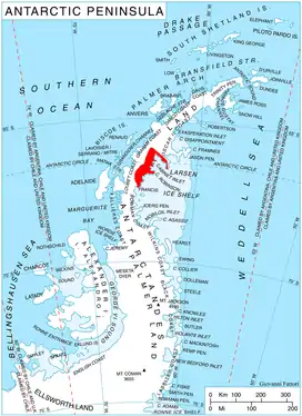
Location of Foyn Coast on Antarctic Peninsula
References
- "Balder Point". Geographic Names Information System. United States Geological Survey. Retrieved 2011-05-18.
![]() This article incorporates public domain material from the United States Geological Survey document: "Balder Point". (content from the Geographic Names Information System)
This article incorporates public domain material from the United States Geological Survey document: "Balder Point". (content from the Geographic Names Information System)
This article is issued from Wikipedia. The text is licensed under Creative Commons - Attribution - Sharealike. Additional terms may apply for the media files.