Ballingarry, North Tipperary
Ballingarry (Irish: Bhaile an Gharraí)[1] is a civil parish and a townland in the barony of Ormond Lower, County Tipperary in Ireland. It is located on the N52 between Borrisokane and Birr.
Ballingarry
Baile an Gharraí | |
|---|---|
Civil parish | |
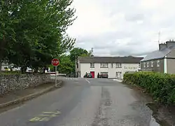 Road junction and pub in Ballingarry | |
 Ballingarry Location in Ireland | |
| Coordinates: 53°01′N 8°02′W | |
| Country | Ireland |
| Province | Munster |
| County | Tipperary |
| Elevation | 76 m (249 ft) |
| Population (2006) | |
| • Total | 575 |
| (Electoral Division of Ballingarry) | |
| Time zone | UTC+0 (WET) |
| • Summer (DST) | UTC-1 (IST (WEST)) |
| Irish Grid Reference | R978962 |
Ballingarry is in the Dáil constituency of Offaly which incorporates 24 electoral divisions that were previously in the Tipperary North Dáil constituency.[2]
Buildings of note
Ballingarry House is a two-storey house which appears on the Council's Record of Protected Structures (ref S21)[3] Within the bawn walls of medieval Ballingarry castle a structure containing 18 bee boles was built about 1820. Constructed of limestone they were designed to keep skeps for nearby Ballingarry House.[4]
Lismacrory Mounds are a collection of Bronze/Iron Age sites located 2.2 km (1.4 mi) to the north of Ballingarry.[5]
The Church of Ireland church is listed as being of architectural, artistic and archeological interest.[6]
Sport and recreation
Knockshegowna GAA is a Gaelic Athletic Association club in Ballingarry. The club are part of the North Tipperary GAA division. The club have been North Tipperary Junior Hurling Champions on nine occasions.[7][8]
Ballingarry is on the route of the Beara-Breifne Way, a long-distance walking and cycling trail from the Beara Peninsula in County Cork to Blacklion in County Cavan.[9]
References
- "Bunachar Logainmneacha na hÉireann - Placenames Database of Ireland". logainm.ie. Retrieved 2013-05-22.
- "Constituency Commission Report 2012 – Waterford - Tipperary - Laois - Offaly - Kildare area" (PDF). Constituency Commission. 14 July 2012.
- "Appendicies". North Tipperary County Council. Archived from the original on November 19, 2007. Retrieved September 1, 2010.
- "Ballingarry Castle, Tipperary North: Buildings of Ireland: National Inventory of Architectural Heritage". Buildingsofireland.ie. Retrieved 2013-05-22.
- https://www.archaeology.ie/sites/default/files/media/pdf/Archaeology-RMP-Tipperary-(NR)-Manual-(1998)-0046.pdf
- http://www.buildingsofireland.ie/niah/search.jsp?type=record&county=TN®no=22400810#
- "Honours". Knockshegowna.com. Archived from the original on 30 October 2013. Retrieved 30 October 2013.
- "Fixtures". Munster GAA. Archived from the original on 30 October 2013. Retrieved 30 October 2013.
- http://bbgreenway.com/towns/ballingarry.html
External links
| Wikimedia Commons has media related to Ballingarry, North Tipperary. |