Ban Lueam District
Ban Lueam (Thai: บ้านเหลื่อม, pronounced [bâːn lɯ̀a̯m]) is a district (amphoe) in the northern part of Nakhon Ratchasima Province, northeastern Thailand.
Ban Lueam
บ้านเหลื่อม | |
|---|---|
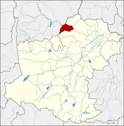 District location in Nakhon Ratchasima Province | |
| Coordinates: 15°36′33″N 102°7′46″E | |
| Country | Thailand |
| Province | Nakhon Ratchasima |
| Seat | Ban Lueam |
| Area | |
| • Total | 218.9 km2 (84.5 sq mi) |
| Population (2009) | |
| • Total | 21,480 |
| • Density | 101.3/km2 (262/sq mi) |
| Time zone | UTC+7 (ICT) |
| Postal code | 30350 |
| Geocode | 3005 |
Etymology
The name Lueam comes from the Ma Lueam tree (Canarium subulatum Guill.). In the past, a big tree of this kind was the landmark of the village.
History
Tambon Ban Lueam, Wang Pho, and Khok Krabueang were separated from Khong District to create a minor district (king amphoe) on 18 October 1976.[1] It was upgraded to a full district on 1 January 1988.[2]
Geography
Neighbouring districts are (from the north clockwise): Kaeng Sanam Nang, Bua Yai, and Khong of Nakhon Ratchasima Province, and Noen Sa-nga and Mueang Chaiyaphum of Chaiyaphum Province.
Administration
The district is divided into four sub-districts (tambons), which are further subdivided into 39 villages (mubans). Ban Lueam is also a sub-district municipality (thesaban tambon) covering parts of tambons Ban Lueam and Wang Pho. There are a further four tambon administrative organizations (TAO).
| No. | Name | Thai | Pop.[3] |
|---|---|---|---|
| 1. | Ban Lueam | บ้านเหลื่อม | 6,465 |
| 2. | Wang Pho | วังโพธิ์ | 2,563 |
| 3. | Khok Krabueang | โคกกระเบื้อง | 8,668 |
| 4. | Cho Raka | ช่อระกา | 3,784 |
References
- ประกาศกระทรวงมหาดไทย เรื่อง แบ่งท้องที่อำเภอคง จังหวัดนครราชสีมา ตั้งเป็นกิ่งอำเภอบ้านเหลื่อม (PDF). Royal Gazette (in Thai). 93 (132 ง special): 2972. October 19, 1976.
- พระราชกฤษฎีกาตั้งอำเภอนามน อำเภอพระยืน อำเภอหนองบัวระเหว อำเภอบ้านเหลื่อม อำเภอจะแนะ อำเภอหนองหงส์ อำเภอนาโพธิ์ อำเภอเกาะยาว อำเภอแกดำ อำเภอสระโบสถ์ อำเภอโนนคูณ อำเภอควนโดน อำเภอไชยวาน อำเภอหนองแสง และอำเภอตาลสุม พ.ศ. ๒๕๓๐ (PDF). Royal Gazette (in Thai). 104 (278 ก special): 33–37. December 31, 1987.
- "Population statistics 2009". Department of Provincial Administration.