Barrie
Barrie is a city and manifesting regional centre in Central Ontario, Canada, located on the shores of Kempenfelt Bay, the western arm of Lake Simcoe. The city is located geographically within Simcoe County, however it is a politically independent single-tier municipality. It is within the historically significant Huronia region of Central Ontario, and is part of the Greater Golden Horseshoe, a densely populated and industrialised sub-region of Ontario. As of the 2016 census, the city's population was 141,434 making it the 34th largest in Canada in terms of population proper. The Barrie census metropolitan area (CMA) as of the same census had a population of 197,059 residents, making it the 21st largest CMA in Canada. The city itself has seen significant growth in recent decades due to its emergence as a bedroom community for Toronto. The affordability of housing and robust job market perhaps contribute to a Toronto buyer's appeasement with Barrie. GO Transit offers daily service to and from the Greater Toronto Area from two stations in the city. Barrie is located 85 kilometres (53 mi) north of Toronto, 355 kilometres (221 mi) northeast of Detroit and 335 kilometres (208 mi) west of Ottawa. This represents the city's highly centralised and historically advantageous situation, providing an ease of access to major centres and airports across the region.[9]
Barrie | |
|---|---|
| City of Barrie | |
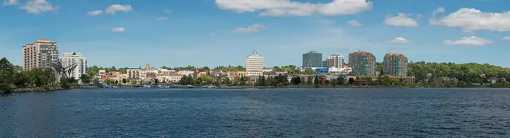
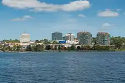 Downtown Barrie from Kempenfelt Bay | |
 Flag | |
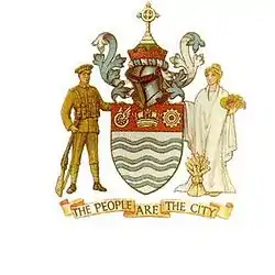
| Motto(s): The People are the City | |
 Barrie Location of Barrie | |
| Coordinates: 44°22′16″N 79°40′37″W | |
| Country | Canada |
| Province | Ontario |
| County | Simcoe (independent) |
| First settled | End of War of 1812 |
| Established | 1854 (village) |
| Established | 1870 (town) |
| Established | 1959 (city) |
| Named for | Sir Robert Barrie |
| Wards | 10 wards
|
| Government | |
| • Mayor | Jeff Lehman |
| • Council | Barrie City Council |
| • MPPS | List of MPPs
|
| • MPs | List of MPs
|
| Area | |
| • City (single-tier) | 99.04 km2 (38.24 sq mi) |
| • Urban | 171.53 km2 (66.23 sq mi) |
| • Metro | 898.02 km2 (346.73 sq mi) |
| Elevation | 252 m (827 ft) |
| Population | |
| • City (single-tier) | 141,434 |
| • Density | 1,428.0/km2 (3,699/sq mi) |
| • Urban | 172,657 |
| • Urban density | 918.27/km2 (2,378.3/sq mi) |
| • Metro | 212,667 |
| • Metro density | 219.4/km2 (568/sq mi) |
| • Ethnicity | Ethnic groups
|
| Demonym(s) | Barrian |
| Time zone | UTC−5 (EST) |
| • Summer (DST) | UTC−4 (EDT) |
| Forward Sortation Area | L4M to L4N, L9J, L9X |
| Area code(s) | 705 and 249 |
| Highways | |
| GNBC Code | FAFFD[8] |
| Website | www.barrie.ca |
The Barrie area was first settled during the War of 1812 as a key supply depot for British forces. It would be named 20 years later after Sir Robert Barrie, who frequently commanded forces through the region. The 1980s and 1990s would be a period of immense growth for Barrie, with the population tripling in the span of twenty-five years. In 1981, the city had a population of 38,423; in 2006, Barrie had 128,430 residents living within city limits. Barrie's ongoing success would be punctuated by high-rise condominium development along Kempenfelt Bay, instigating a sort of downtown renaissance. Great investment by the city into their beachfront amenities would culminate in Barrie becoming a prime tourist destination. With several ski resorts in the vicinity and a picturesque waterfront, Barrie is known not just for its tourism, but also as the 'Gateway to Cottage Country'.[10] The city's economy is diverse, with education, healthcare, information technology and manufacturing all prevalent sectors. The Royal Victoria Regional Health Centre is Barrie's largest employer, with nearly 3,000 workers. Retail in the city has flourished too in recent decades, bolstered by the completion of Park Place in 2008. Barrie experiences cold, snowy winters with an average January minimum temperature of −12.4 °C (9.7 °F). Summers are hot and humid, with an average July maximum temperature of 26.3 °C (79.3 °F).[10]
History
Before 1900
At its inception, Barrie was an establishment of houses and warehouses at the foot of the Nine Mile Portage from Kempenfelt Bay to Fort Willow, an aboriginal transportation route that existed centuries before Europeans arrived in Simcoe County. The portage linked Kempenfelt Bay through Willow Creek, connecting Lake Simcoe to the Nottawasaga River which flows into Georgian Bay off Lake Huron.
Barrie played an integral role in the War of 1812. During the war, the city became a supply depot for British forces and, in addition, the Nine Mile Portage was adopted by the British military as a key piece of their supply line which provided a strategic path for communication, personnel and vital supplies and equipment to and from Fort Willow and Georgian Bay/Lake Huron. Today, the Nine Mile Portage is marked by signs along roads in Barrie and in Springwater Township. The scenic path from Memorial Square to Fort Willow is accessible to visitors year-round.
The city was named in 1833 after Sir Robert Barrie, who was in charge of the naval forces in Canada and frequently commanded forces through the city and along the Nine Mile Portage. Barrie was also the final destination for a branch of the Underground Railroad. In the mid-19th century, this network of secret routes allowed many American slaves to enter Barrie and the surrounding area. This contributed to the development (and name) of nearby Shanty Bay. In 1846, the population of Barrie was roughly 500, mostly from England, Ireland and Scotland. A private school, three churches, a brick courthouse and a limestone jail, (built in 1842), were in operation.[11] Local businesses included three taverns, six stores, three tanneries, a wagon maker, a bakery, a cabinet maker and six shoemakers, as well as a bank.[12]
In 1869, Barrie became the county seat of Simcoe County, flourishing with a population of over 3,000 people. It was a station of the Northern Railway and was located on Lake Simcoe's western arm, known as Kempenfelt Bay. Throughout the latter of the 19th century, Steamships ran from Barrie to the Muskoka Territory, Orillia and other communities and stages were taking passengers to Penetanguishene.[13]
The period of 1870 to 1890 defined Barrie's downtown development with a series of raging fires that sequentially destroyed multiple landmarks, giving rise to the moniker that Barrie was "among the best burning towns in Canada." [14] Many local businesses like breweries, tanneries and sawmills depended on fire to operate, endangering the ramshackle assortment of wooden homes and buildings that made up the city centre.
One of the most destructive fires came in mid-1875, when the entire section north of Dunlop to Collier, bounded by Clapperton and Owen Streets, was reduced to ash, destroying around 20 local businesses.
20th Century
In the next century, the modern streets and buildings of Barrie began to take form in a massive rebuilding process. Other landmarks to eventually burn down over the years include the Barrie Opera House (1926), The Queen's Hotel (1915) and two of Barrie's largest and most prominent companies; the Sevigny Carriage Shop and the Anderton Brewery in 1916.[14]
In the midst of World War I, dedicated residents of Barrie helped to hastily construct Canadian Forces Base Borden (CFB Borden) as a means of additional support and to serve as a major training centre of Canadian Expeditionary Force battalions. The base would open on July 11, 1916, and since then has become the largest Canadian Forces Base in the country, playing a paramount role through the remainder of the war, and throughout history. During World War II, the Royal Canadian Navy named a Flower-class corvette HMCS Barrie.
On September 7, 1977, a private aircraft dropped to an altitude of 500 feet (152 m) in dense fog and struck the 1,000-foot (305 m) CKVR-TV tower, killing all five occupants aboard the plane and destroying the tower and antenna. The station's 225-foot (69 m) auxiliary tower was also destroyed and damage had been inflicted on the roof of the main studio. CKVR was back on the air in the weeks following using a temporary 400-foot (122 m) tower; a power reduction of nearly 40,000 watts occurred upon their return to the air on September 19 at 8:55 p.m. The new 1,000-foot tower was rebuilt in 1978.
On May 31, 1985, an F4 tornado struck Barrie, touching down in Essa Township, less than 10 kilometres (6.2 mi) southwest of Highway 400 and the Barrie city limits. At approximately 4:00 PM, all electrical power in Barrie went out, as the Grand Valley/Tottenham tornado took out the main hydro transformers southwest of the city. It then entered the southern part of Barrie shortly before 5:00pm, causing devastating damage in the subdivisions within its immediate path. The visibility in the general vicinity had been reduced drastically as the tornado was cloaked in heavy rain and dust. It became known as one of the most violent and deadliest tornadoes in Canadian history, claiming the lives of eight within the city and injuring over 155 people. A state of emergency had been issued for the city that evening, with services from surrounding municipalities being required as the weeks following wore on.
Between June 12–13, 1987, a sculpture called Spirit Catcher by Ron Baird was moved to Barrie from Vancouver, British Columbia, where it had been exhibited as part of Expo '86. The sculpture was erected permanently at the foot of Maple Avenue on the shore of Kempenfelt Bay and has since become a principal facet in the Barrie city skyline and tourism. However, with the re-development along the waterfront and Lakeshore Drive, the city is considering moving the Spirit Catcher to a gravel outcropping at the foot of Bayfield Street.
21st Century
On January 12, 2004, the former Molson Brewery in south Barrie was found to be home to an illegal marijuana grow-op housing an estimated 30,000 marijuana plants with an estimated street value of $30 million; at the time, it was the largest marijuana grow-op bust in Canada's history. Barrie's Park Place (formerly Molson Park) was chosen to host Live 8 Canada on July 2, 2005.[15] The overall success of the concert contributed to a plan to convert the prior Molson Park lands into a commercial district.
On October 31, 2006, commercial real estate developers North American Acquisition Inc (NAA), a subsidiary of North American Development Group, LLC (NADG) won an Ontario Municipal Board (OMB) appeal of a rezoning application that had been previously denied by the City of Barrie to rezone the new Park Place lands from general industrial to business park zones, and general commercial or mixed employment. The proposal was followed by several concepts, including a box store abstraction originally conceived in 2002. The development of the lands was halted temporarily in 2009 due to disputes with the past OMB appeal, and construction of the complex would resume in 2010.
An explosion in the Royal Thai restaurant, housed in the landmark Wellington Hotel at the "Five Points" intersection in downtown Barrie, occurred at 11:20pm on December 6, 2007. The fire quickly spread to several neighbouring buildings and firefighters battled the blaze well into the following morning, requiring assistance from other Simcoe County fire services. Officials estimated the damages to be in the millions. The 100-year-old Wellington Hotel building collapsed later in the morning.[16][17] On February 17, 2008, two people were charged in connection with the fire after the Ontario Fire Marshal's office concluded the explosion and subsequent fire were the result of arson.[18]
Geography
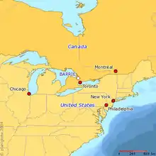
Barrie is located in the central portion of Southern Ontario, approximately 80 km (50 mi) north of Toronto, 303 km (188 mi) south southeast of Sudbury and 412 km (256 mi) west southwest of Ottawa, within the Greater Golden Horseshoe subregion. It is additionally located approximately 38 km (24 mi) southeast of the sought-after summertime destination, Wasaga Beach and 112 km (70 mi) south of the Muskoka District Municipality and cottage country, accessible via Highways 26, 400 and 11. Barrie's historic downtown area is located in a distinct curved or wrapped valley, surrounding the western edge of Kempenfelt Bay. The terrain is generally flat near the city's centre, with small but relevant hills and valleys being prominent astride the aforementioned. Moving up the valley slopes toward the city's north and south ends and the terrain can be rather steep in some areas. The earth flattens considerably just outside the city's limits to the south and northeast, especially beyond the airport where vast expanses of vegetation and farmland are most notable. The land surrounding Barrie is rich with agricultural activity. Barrie falls into Plant Hardiness Zone 5b. The city does not have any major rivers within its limits but does have numerous creeks and streams, most of which empty into Kempenfelt Bay.
Interurban communities
- Cundles
- Letitia Heights
- Ferndale
- Ardagh Bluffs
- The Grove
- Eastview
- Holly
- Downtown
- Painswick
- Allandale
- Minet's Point
- St. Paul's
Expansion
Barrie has been designated an Urban Growth Centre by the Province of Ontario (Places to Grow Simcoe Area, 2009). Its population growth, largely due to its emergence as a bedroom community for Toronto, has given rise to the development of numerous subdivisions on the southern side of the city. Barrie successfully annexed 2,293 hectares (22.93 km2) of land from the neighbouring Town of Innisfil to the south and southeast on January 1, 2010.[19] The annexation comprised lands south beyond McKay Road and west of the 10th Sideroad, and as far south as Lockhart Road on the east side of the 10th Sideroad.[20] The annexation was intended to allow Barrie to meet its growing population demands without having to extend into the lush countryside on the northern, western, and eastern lakeside boundaries of the city's limits.
Climate
| Barrie | ||||||||||||||||||||||||||||||||||||||||||||||||||||||||||||
|---|---|---|---|---|---|---|---|---|---|---|---|---|---|---|---|---|---|---|---|---|---|---|---|---|---|---|---|---|---|---|---|---|---|---|---|---|---|---|---|---|---|---|---|---|---|---|---|---|---|---|---|---|---|---|---|---|---|---|---|---|
| Climate chart (explanation) | ||||||||||||||||||||||||||||||||||||||||||||||||||||||||||||
| ||||||||||||||||||||||||||||||||||||||||||||||||||||||||||||
| ||||||||||||||||||||||||||||||||||||||||||||||||||||||||||||
Barrie has a humid continental climate (Köppen climate classification Dfb), with warm, humid summers, and cold, snowy winters. The city is located on Lake Simcoe, a climatically insignificant body of water. Barrie is located in close proximity to Georgian Bay, which, along with the Great Lakes, act as a "buffer" of sorts, moderating year-round temperatures to a fair extent, while combined with the lake effect can spawn blinding snow squalls in the winter, and strong thunderstorms in the spring and summer. The average July maximum in Barrie is 26.3 °C (79 °F), while the average January minimum is −12.4 °C (10 °F).
Barrie experiences four distinct seasons, with considerable variance in length. As a result of the rapid passage of weather systems (such as high- and low-pressure systems), the weather is variable from day to day in all seasons, similar to Toronto, the city's southern neighbour. Barrie does not, however, see the effects of diurnal temperature variation, owing to its northerly location and rural outskirts. The city can be subject of noticeably cooler afternoons in the spring and early summer, due to the influence of a lake breeze since nearby lakes, such as Lake Huron, are cool relative to the air during these seasons. These aforementioned "lake breezes" mostly occur throughout the summer, bringing much-needed relief on hot days. Other low-scale maritime effects on the climate include constant lake-effect snow in the winter, fog and delaying of spring- and fall-like conditions, known as seasonal lag.
Winters are typically cold with frequent snow. During the winter months, temperatures are usually below 0 °C (32 °F). Barrie winters sometimes feature cold snaps when maximum temperatures remain below −10 °C (14 °F), often made to feel colder by a biting wind chill. Occasionally, temperatures can drop below −25 °C (−13 °F). Snowstorms, sometimes mixed with ice and rain, can disrupt work and travel schedules, while accumulating snow can fall anytime from late-October until mid-April. However, on the contrary, mild bouts also occur in most winters, melting any accumulated snow.
The summer months are characterized by very warm temperatures and muggy conditions. Daytime temperatures are normally above 20 °C (68 °F), and often rise above 30 °C (86 °F). However, they can sometimes surpass 35 °C (95 °F), accompanied by high humidity. The short transitional seasons of spring and autumn have generally mild or cool temperatures with alternating periods of dry and wet. Daytime temperatures average around 10 to 12 °C (50 to 54 °F) during these seasons. Precipitation is fairly evenly distributed throughout the year, but summer is usually the wettest season, the bulk falling during thunderstorms.
Barrie is known for heavy thunderstorm activity in the late spring and summer months, all due to its location within a convergence of breezes originating from Georgian Bay, Lake Ontario and Lake Erie. There can be short periods of dry weather, but drought-like conditions are rare. The average yearly precipitation is about 932 millimetres (37 in), with an average annual snowfall of about 223 centimetres (88 in). The highest temperature ever recorded in Barrie was 38.9 °C (102 °F) on July 5, 1911.[22] The coldest temperature ever recorded was −38.9 °C (−38 °F) on January 8, 1866.[23]
| Climate data for Barrie Water Pollution Control Centre – 1981–2010[lower-alpha 1] | |||||||||||||
|---|---|---|---|---|---|---|---|---|---|---|---|---|---|
| Month | Jan | Feb | Mar | Apr | May | Jun | Jul | Aug | Sep | Oct | Nov | Dec | Year |
| Record high humidex | — | — | 28 | 36 | 39 | 43 | 48 | 44 | 32 | 35 | 26 | — | 48 |
| Record high °C (°F) | 15.0 (59.0) |
14.0 (57.2) |
26.5 (79.7) |
30.5 (86.9) |
35.0 (95.0) |
35.6 (96.1) |
38.9 (102.0) |
37.8 (100.0) |
35.6 (96.1) |
30.0 (86.0) |
25.6 (78.1) |
19.5 (67.1) |
38.9 (102.0) |
| Average high °C (°F) | −2.9 (26.8) |
−1.5 (29.3) |
3.2 (37.8) |
11.0 (51.8) |
18.1 (64.6) |
23.6 (74.5) |
26.3 (79.3) |
25.1 (77.2) |
20.7 (69.3) |
13.5 (56.3) |
6.5 (43.7) |
0.4 (32.7) |
12.0 (53.6) |
| Daily mean °C (°F) | −7.7 (18.1) |
−6.6 (20.1) |
−2.1 (28.2) |
5.6 (42.1) |
12.3 (54.1) |
17.9 (64.2) |
20.8 (69.4) |
19.7 (67.5) |
15.3 (59.5) |
8.7 (47.7) |
2.7 (36.9) |
−3.5 (25.7) |
6.9 (44.5) |
| Average low °C (°F) | −12.4 (9.7) |
−11.7 (10.9) |
−7.4 (18.7) |
0.2 (32.4) |
6.5 (43.7) |
12.3 (54.1) |
15.3 (59.5) |
14.3 (57.7) |
10.0 (50.0) |
3.9 (39.0) |
−1.0 (30.2) |
−7.3 (18.9) |
1.9 (35.4) |
| Record low °C (°F) | −38.9 (−38.0) |
−37.2 (−35.0) |
−30.5 (−22.9) |
−15.0 (5.0) |
−5.6 (21.9) |
−2.2 (28.0) |
4.4 (39.9) |
0.0 (32.0) |
−3.9 (25.0) |
−8.3 (17.1) |
−21.1 (−6.0) |
−36.7 (−34.1) |
−38.9 (−38.0) |
| Record low wind chill | −41 | −44 | −37 | −20 | −7 | — | — | — | −4 | −10 | −37 | −42 | −44 |
| Average precipitation mm (inches) | 82.5 (3.25) |
61.8 (2.43) |
58.1 (2.29) |
62.2 (2.45) |
82.4 (3.24) |
84.8 (3.34) |
77.2 (3.04) |
89.9 (3.54) |
94.0 (3.70) |
77.5 (3.05) |
88.9 (3.50) |
73.6 (2.90) |
932.9 (36.73) |
| Average rainfall mm (inches) | 16.6 (0.65) |
16.0 (0.63) |
29.2 (1.15) |
56.6 (2.23) |
82.3 (3.24) |
84.8 (3.34) |
77.2 (3.04) |
89.9 (3.54) |
94.0 (3.70) |
75.2 (2.96) |
66.0 (2.60) |
22.2 (0.87) |
710 (27.95) |
| Average snowfall cm (inches) | 65.9 (25.9) |
45.9 (18.1) |
29.0 (11.4) |
5.7 (2.2) |
0.1 (0.0) |
0.0 (0.0) |
0.0 (0.0) |
0.0 (0.0) |
0.0 (0.0) |
2.3 (0.9) |
22.8 (9.0) |
51.4 (20.2) |
223.1 (87.7) |
| Average precipitation days (≥ 0.2 mm) | 14.9 | 12.3 | 11.6 | 12.2 | 12.9 | 11.4 | 11.1 | 11.8 | 13.3 | 15.6 | 15.4 | 13.8 | 156.3 |
| Average rainy days (≥ 0.2 mm) | 2.8 | 3.0 | 5.4 | 11.3 | 12.9 | 11.4 | 11.1 | 11.8 | 13.3 | 15.5 | 11.3 | 4.6 | 114.4 |
| Average snowy days (≥ 0.2 mm) | 12.4 | 10.0 | 6.8 | 1.5 | 0.04 | 0.0 | 0.0 | 0.0 | 0.0 | 0.54 | 4.5 | 9.6 | 45.38 |
| Average relative humidity (%) | 80.00 | 76.58 | 72.27 | 68.50 | 69.15 | 74.04 | 74.73 | 77.80 | 79.64 | 79.96 | 81.56 | 82.80 | 76.42 |
| Average ultraviolet index | 1.09 | 1.45 | 1.82 | 2.82 | 4.18 | 4.73 | 5.40 | 4.90 | 3.50 | 2.10 | 1.60 | 1.20 | 2.90 |
| Source: Temperature, and precipitation (rain/snow) from Environment Canada,[21][24][25] relative humidity, wind chill, humidex, and sunshine data from weatherstats.ca based on Environment and Climate Change Canada data,[26] UV indices from World Weather Online.[27] | |||||||||||||
Demographics
| Year | Pop. | ±% |
|---|---|---|
| 1841 | 500 | — |
| 1871 | 3,398 | +579.6% |
| 1881 | 4,854 | +42.8% |
| 1891 | 5,550 | +14.3% |
| 1901 | 5,949 | +7.2% |
| 1911 | 6,420 | +7.9% |
| 1921 | 6,936 | +8.0% |
| 1931 | 7,776 | +12.1% |
| 1941 | 9,559 | +22.9% |
| 1951 | 12,514 | +30.9% |
| 1961 | 21,169 | +69.2% |
| 1971 | 27,676 | +30.7% |
| 1981 | 38,423 | +38.8% |
| 1991 | 62,728 | +63.3% |
| 1996 | 79,191 | +26.2% |
| 2001 | 103,710 | +31.0% |
| 2006 | 128,430 | +23.8% |
| 2011 | 136,063 | +5.9% |
| 2016 | 141,434 | +3.9% |
| Note: 2011 census population corrected by Statistics Canada[5] | ||
Barrie is one of the most populous municipalities and census metropolitan areas in the Greater Golden Horseshoe subregion. In the 2016 census, the city's population increased to 141,434, a growth of 3.9% over the 2011 population of 136,063. The median age is 38.5 years, somewhat lower than the provincial average of 39.0 years.[3] The census metropolitan area of Barrie is 197,059 and consists of the city proper; the town of Innisfil directly to the south, west of Lake Simcoe's southern arm (population 36,566); and the township of Springwater in the agricultural north (population 19,059).
Barrie has a total land area of 898.02 square kilometres (346.73 sq mi) in its metropolitan area, with a significant portion of the precinct being farmland or grassland. Roughly 40% of the Barrie census metropolitan area is developed land. In the 2016 census, Barrie's "bedroom community" for that of the city of Toronto distinction would be represented once again in another census by its demography.
Barrie's median household income was $113,575, far higher than Ontario's median of $74,287, potentially depicting the higher-paying occupations available in the Greater Toronto Area as opposed to those offered within city limits.[3] Barrie's economic stature is not lacking; however, several jobs are offered across different fields locally.
Barrie's average commute time is the third highest in Ontario, at 59 minutes, also possibly displaying the populace's tendency to work abroad in the more desirable and opportunity-oriented south. Barrie's average dwelling value was $395,994, demonstrating a lower household cost than the provincial mean of about $517,000 and a national average of roughly $496,500.
| Canada census – Barrie community profile | |||
|---|---|---|---|
| 2016 | 2011 | ||
| Population: | 141,434 (3.9% from 2011) | 136,063 (5.9% from 2006) | |
| Land area: | 99.04 km2 (38.24 sq mi) | 77.39 km2 (29.88 sq mi) | |
| Population density: | 1,428.0/km2 (3,699/sq mi) | 1,758.1/km2 (4,553/sq mi) | |
| Median age: | 38.5 (M: 36.9, F: 40.0) | 37.2 (M: 36.0, F: 38.3) | |
| Total private dwellings: | 54,227 | 50,075 | |
| Median household income: | $113,575 | $80,928 | |
| References: 2016[28] 2011[29] earlier[30] | |||
Ethnicity
Barrie is approximately 84.2% white, 10.3% visible minorities and 5.5% aboriginal. The largest visible minority groups in the city are Black (2.7%), South Asian (2.2%), Chinese (1.2%) and Latin American (1.1%).[31] The city's bilingualism is rather distinguished, with a fair francophone population of about 9,660 people (or 6.8% of the total population). This proportion is higher than the Ontario average of 2.4%. Some 92.2% of the population speak mostly English at home.
According to the 2011 National Household Survey, the residents of Barrie are predominantly Christian. Around 67% of the population claims adherence to Christian denominations, with a Catholic, United Church and Anglican majority, accounting for 41.2%, 14.2% and 13.7%, respectively, of the total separate Christian statistical figure. Those with no religious affiliation accounted for 31% of the population, and other religions such as Islam, Judaism, Buddhism, Hinduism, Sikhism and other religions all constitute around one per cent of the population. Visible minorities in Barrie comprise 7.4%, compared to the Canadian average of 19.1%.
Religious affiliation
| Religious Affiliation[32] | Total |
|---|---|
| Buddhist | 595 |
| Anglican | 11,950 |
| Baptist | 3,760 |
| Catholic | 36,590 |
| Christian Orthodox | 1,235 |
| Lutheran | 1,460 |
| Pentecostal | 2,090 |
| Presbyterian | 5,140 |
| United Church | 12,315 |
| Other Christian | 13,830 |
| Hindu | 405 |
| Jewish | 660 |
| Islam | 1,405 |
| Sikh | 140 |
| Traditional (Aboriginal) Spirituality | 35 |
| Other religions | 350 |
| No religious affiliation | 41,275 |
Economy
The following are some of the city's major employers:
- Royal Victoria Regional Health Centre
- Georgian College and the associated University Partnership Centre and Centre for Health and Wellness
- City of Barrie
- County of Simcoe
- Simcoe County District School Board
- TD Canada Trust and TD Waterhouse Regional Centre
- TD Canada Trust Technology and Operations Centre
- Scotiabank Regional Centre
- BMO Data Centre
- IBM Canada Leadership Data Centre
- The Source Distribution Centre
- Coca-Cola Bottling Company
- Canadian Mental Health Association - Simcoe
- Hydro One Ontario Grid Control Centre
Notwithstanding these major employers, Barrie has increasingly been perceived as a bedroom community for people commuting to Toronto, which is approximately 90 km (56 mi) south of Barrie. Approximately 32% of the resident-employed labour force (17,040 persons/53,400 persons) commute out of Barrie for employment purposes; however, approximately 28% of the resident-employed labour force (14,880 persons/53,400 persons) commute into Barrie for employment for a net out-commuting figure of only 4.26% (17,040 persons –14,880 persons)/(50,665 persons employed in Barrie)). Source: 2001 Census and City of Barrie Economic Development.
Tourism
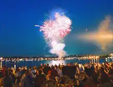
Tourism plays an important role in the local economy. Barrie's historic downtown and waterfront are at the heart of its tourism industry. Downtown Barrie hosts many older buildings that have been kept up over the years or given new facades that exemplify their historical importance. Many speciality shops, boutiques, pubs and restaurants are located throughout downtown Barrie, most notably along Dunlop Street East. Downtown Barrie is becoming well known for its fashion boutiques, local art, live theatre, indie-music and nightlife scenes.[33] In addition, downtown Barrie is home to numerous annual festivals and events such as The Barrie Waterfront Festival, Barrielicious, Winterfest, Celebrate Barrie, Ecofest, Jazz & Blues Festival, Promenade Days, Ribfest and Craft Beer Show, Caribfest, Lawnchair Luminata, Kempenfest, The New Music Festival, Barrie Film Festival, Santa Claus Parade and the New Year's Countdown.[34]
In the summer months, the city boasts several beaches including Minet's Point Beach, Johnsons Beach, The Gables, Tyndale Beach, and Centennial Beach.[35] Boating is also very popular in Kempenfelt Bay and Lake Simcoe as it connects to the Trent Severn Waterway. In 2011, Barrie's waterfront was under redevelopment, with the relocation of several roadways to provide more greenspace and parkland along the lakeshore. There are numerous winter recreation activities and facilities in the surrounding area, including skiing, snow tubing and snowboarding resorts, snowmobile, snowshoe and nordic skiing trails, and ice fishing. Recreational activities include skiing at nearby Horseshoe Resort, Snow Valley, Mount St. Louis Moonstone, Blue Mountain and Hardwood Ski and Bike.[36]
Arts and culture
Barrie is home to vibrant performing and fine arts scenes. There are a number of live performance companies including Theatre by the Bay, Talk Is Free Theatre and the Huronia Symphony. Grove Park Home is the practice hall for On-Stage Performance Group which performs in Cookstown. The Strolling Youth Players and the Kempenfelt Community Players also all perform in Barrie. In addition, an annual live concert series is hosted by Georgian College.
Performing Arts
There are two main performing arts venues in the city: the Five Points Theatre, and the Georgian Theatre. Originally, the Five Points Theatre was known as The Mady Centre For The Performing Arts, but it was renamed in January 2018. It is located in Barrie's downtown at the Five Points intersection and was completed in 2011. This modern facility is home to many professional and amateur cultural productions, film screenings, theatrical plays, concerts, dance recitals and other performances. It is also the main venue for Theatre by the Bay and the Talk Is Free Theatre Companies. The venue features a flexible stage area with lighting and sound for professional theatre, music, dance, and other presentations, an automated riser/seating system with capacity for 120-200 seats and a sprung performance floor.
The Georgian Theatre is a professional performing arts facility located in Barrie's north end on the campus of Georgian College. The theatre features a proscenium stage, sound, lights, fly gallery and seating for 427 on the main level with three pods which can be used to increase the seating capacity to 690. The Theatre is used for both theatrical and non-theatrical activity including conferences and seminars.
Galleries

The prominent MacLaren Art Centre is located in Barrie. This is an art gallery that inspired the "Art City" project, which has had many different large sculptures installed around the city. These can be found in parks and along the waterfront.
Barrie is also home to many independent galleries and studios. A concentration of independent galleries, studios and boutiques is located in Lakeshore Mews. This area is located behind the downtown's Dunlop Street. Lakeshore Mews artists also organize the annual "Arts ce Soir"; an all-night contemporary art event in celebration of visual, musical, theatrical and literary art.
In addition, a studio tour in the Barrie/Orillia area takes place on the Canadian Thanksgiving weekend every year. It is called the Images Studio Tour and has over 25 artists on average. Potters, jewellers, painters, textile artists and fashion designers make up a few of the disciplines of the talents on display.
Festivals
Barrie is home to Kempenfest; one of the largest outdoor arts and crafts celebrations in Ontario. This festival occurs annually over the August long weekend and features over 300 artisans, an antique show, food demonstrations, children's activities and live entertainment, including an indie-music stage.
Groups
Some of the main arts and culture groups in the city include:
- Barrie Art Club
- Barrie Concert Band[37]
- Barrie Film Festival
- Barrie Folk Society[38]
- Campus Gallery
- Caribbean Culture Institute
- Huronia Symphony Orchestra[39]
- Kempenfelt Community Players
- King Edward Choir[40]
- Lyrica Chamber Choir
- Simcoe Contemporary Dancers
- Talk Is Free Theatre
- Theatre By The Bay
- Kiwanis
Attractions
Barrie has numerous recreational venues and community centres throughout the city:
- Allandale Recreation Centre
- Barrie Community Sports Complex
- Barrie Public Library
- Barrie Uptown Theater
- Dorian Parker Centre
- East Bayfield Community Centre
- Eastview Arena
- Holly Community Centre
- Lampman Park
- Lampman Lane Community Centre
- Parkview Community Centre
- Southshore Community Centre
- Victoria Village
- YMCA of Barrie
Sports
| Club | League | Venue | Established | Championships |
|---|---|---|---|---|
| Barrie Colts | OHL Hockey | Sadlon Arena | 1995 | 1 |
| Barrie Baycats | IBL Baseball | Coates Stadium | 2001 | 7 |
| Georgian Grizzlies | OCAA | Georgian College | 1967 | |
| Barrie Sharks | PWHL Hockey | East Bayfield Community Centre | 2011 | 0 |
| 1812 FC Barrie[41] | League1 Ontario | J.C. Massie Field | 2021 | 0 |
Barrie is also home to the Mariposa School of Skating, which has trained many world-class figure skaters, including Brian Orser, Elvis Stojko and Jeffrey Buttle.
Government
Municipal
The current mayor of Barrie is Jeff Lehman, who was elected in November 2010, succeeding Dave Aspden.
Provincial
| Party | Members of Provincial Parliament | From | To | Riding | |
|---|---|---|---|---|---|
| Progressive Conservative | Andrea Khanjin | June 7, 2018 | present | Barrie—Innisfil | |
| Progressive Conservative | Doug Downey | June 7, 2018 | present | Barrie—Springwater—Oro-Medonte | |
Federal
| Party | Members of Parliament | From | To | Riding | |
|---|---|---|---|---|---|
| Conservative | John Brassard | October 19, 2015 | present | Barrie—Innisfil | |
| Conservative | Doug Shipley | October 21, 2019 | present | Barrie—Springwater—Oro-Medonte | |
Military
Barrie has a long military history dating back to at least the Nine Mile Portage of the War of 1812. By the time of the 1837 Rebellion, Simcoe County had a sufficient population to form a battalion of Sedentary Militia of almost 600 strong. This battalion was involved in marching suspected rebels down Yonge Street to Toronto in order to face justice. By 1855, Barrie was home to an independent company of Rifle Company of militia, followed in 1863 by a company of Infantry. These companies served during the Fenian Raids. With the Militia Act of 1866, the companies in Barrie were respectively organized as Number 1 and Number 5 companies, in the newly formed 35th Battalion of Infantry (Simcoe Foresters), gazetted on September 14, 1866.
In 1885, four companies the 35th Simcoe Foresters, including those from Barrie, formed with four companies from the 12th York Battalion to form the York-Simcoe Battalion. This specially raised battalion served in Western Canada during the Northwest Rebellion, under the command of Lieutenant-Colonel W.E. O'Brien of Shanty Bay, Ontario. For its efforts, The Simcoe Foresters received its first Battle Honour "Northwest Canada 1885". Citizens of Barrie would next volunteer for military service during the Boer War in South Africa 1899–1902. It was during this conflict that at the Battle of Paardeberg the citizens of Barrie and The Simcoe Foresters suffered their first fatal casualty, Private James Halkett Findlay. Private Findlay was killed-in-action on February 18, 1900, while serving with C Company of the 2nd Battalion Royal Canadian Regiment of Infantry.
In 1914, the First World War broke out and many citizens of Barrie were quick to volunteer for service overseas with The Simcoe Foresters. Late the following year, the Regiment was tasked with raising two overseas battalions, the 157th Battalion (Simcoe Foresters), CEF and the 177th Battalion (Simcoe Foresters), CEF. In the spring of 1916, the Barrie and Collingwood companies of the 157th Battalion began clearing the land and construction of the new military camp on the Simcoe Pines Plain — Camp Borden (now CFB Borden). This began Barrie's long friendship with the Base, hence the reason CFB Borden was used for Canada's Worst Driver 2 and Canada's Worst Driver 5.
With a re-organization of the Canadian Militia between the two world wars, The Simcoe Foresters, headquartered in Barrie, were amalgamated in 1936 with the Grey Regiment, headquartered at Owen Sound, Ontario. This event created the present-day regiment of The Grey and Simcoe Foresters, which is headquartered at the Armoury in Queen's Park, downtown Barrie. With the outbreak of the Second World War in 1939, citizens of Barrie volunteered for service overseas with The Grey and Simcoe Foresters, the Royal Canadian Navy and the Royal Canadian Air Force. The City of Barrie sponsored a ship in the Royal Canadian Navy, HMCS Barrie, a Flower-class corvette.
Transportation
Airports
There are no major airports with scheduled flights near Barrie (the closest being Toronto Pearson International Airport, located in Mississauga). There are a few airports that are used for light aviation aircraft:
Roads
Barrie is served by Provincial Highway Highway 400, which acts as the primary route between Barrie and Toronto. Highway 400 bisects the city on a roughly north–south basis. Highway 26, also located in the city, is the main route to the Collingwood area and is known as Bayfield Street within the city limits. Barrie was once served by Highway 27, Highway 90, Highway 93, Highway 131 and Highway 11. However, the province downgraded many highways in 1997 and 1998; these highways are now known as Simcoe County Road 27, Simcoe County Road 90 (Dunlop Street), Simcoe County Road 93 and Simcoe County Road 30.
The portion of Highway 11 through Barrie is known as Yonge Street, though it is actually part of the Penetanguishene Road. Major arterial roads within the city include Mapleview Drive, Ferndale Drive, 10th Line, Big Bay Point Road, Essa Road, Huronia Road, Bayfield Street, Cundles Road, Anne Street, Dunlop Street, Livingstone Street, Duckworth Street, Wellington Street and St. Vincent Street.
Public transit
Public transport is provided by Barrie Transit, which operates numerous bus routes within the city. Accessible transit is offered by booking with city run Barrie Accessible Community Transportation Service. Most regular bus routes operated by Barrie Transit are accessible using low floor vehicles. Barrie also has GO Trains and Buses.
Interurban/commuter rail
GO Transit connects the city to the Greater Toronto Area through daily train service along the Barrie line, with trains operating from the Allandale Waterfront GO Station and the Barrie South GO Station. This is primarily a commuter rail service to the GTA, with southbound trips to Toronto's Union Station in the morning rush hour and northbound trips in the evening rush hour. Limited weekend service to and from Toronto is also operated.
Interurban/commuter bus
In addition to train service, GO Transit offers daily commuter-oriented bus service to the Greater Toronto Area. Barrie is served by various private interurban bus lines such as Penetang-Midland Coach Lines and parent Greyhound Canada, which run buses between Barrie and Toronto's Yorkdale Bus Terminal. Greyhound operates QuickLink commuter service from Barrie to Toronto seven days a week. In the past Gray Coach offered service from Toronto to Barrie; the route was later acquired by Greyhound. Ontario Northland operates bus routes from various locations to and from Barrie. All inter-urban buses operate from the Barrie Transit Terminal at 24 Maple Street.
Passenger rail
Historically, Barrie was served by scheduled passenger rail service. Allandale Station was a stop for the Grand Trunk Railway, Canadian National Railway and Via Rail. In addition, Ontario Northland's Northlander used the station as a stop, as did CN Rail/Via Rail (namely The Canadian). Regular passenger rail service to the station ended in the 1980s and has largely been replaced by interurban / commuter rail service.
Education
Barrie has two major English school boards that operate inside the city at a public level. The Simcoe County District School Board administers a Public education in Barrie and Simcoe County, while the Simcoe Muskoka Catholic District School Board administers to the Catholic population and serves the Simcoe and Muskoka areas. It also has two French school boards, Conseil scolaire catholique MonAvenir (formerly Conseil scolaire de district catholique Centre-Sud), the Catholic board, and Conseil scolaire Viamonde (CSV, formerly Conseil Scolaire de District du Centre-Sud-Ouest), the secular board. There are also several private schools both for K-8 and K-12.
High schools
- Barrie North Collegiate Institute
- Bear Creek Secondary School
- Eastview Secondary School
- École Secondaire Catholique Nouvelle Alliance
- Innisdale Secondary School
- St. Joseph's High School
- Saint Joan of Arc
- St. Peter's Catholic Secondary School
- École secondaire Roméo Dallaire
- Unity Christian High School
Georgian College
Georgian College's main campus, with over 10,000 full-time students and approximately 25,000 part-time students, is located in Barrie.
Media
Online
Village Media operates BarrieToday.com.
Print
There are both semi-weekly and monthly newspapers serving the City of Barrie. The Barrie Advance, published by Metroland Media Group, is a free newspaper established in 1983 and delivered weekly (on Thursdays) to every residence in the city as well as residents of Springwater Township and parts of Oro-Medonte. The newspaper contains local news, classifieds, advertisements and flyers. Barrie Business is a free newsprint publication covering local and regional business news. Published monthly and distributed to every business in the City of Barrie through Canada Post, it seeks to highlight and support Barrie's local business community and events. The Barrie Examiner, established in 1864, was one of Canada's oldest daily newspapers. It was distributed five days a week (Tuesday to Saturday) to paid subscribers and also delivered to the remainder of the market free on Thursdays. The Examiner was one of several Postmedia Network newspapers purchased by Torstar in a transaction between the two companies in 2017.[42] Following the acquisition, Torstar subsidiary Metroland Media Group announced the closure of the paper effective November 27, 2017.[43][44]
Television
CKVR-DT (CTV 2 Barrie) is Barrie’s one and only television station producing about 1.30 hours of local programming on weekdays such as local news at six and eleven and an hour of local programming on weekends also at six and eleven.
Radio
Local radio stations serving Barrie and environs include:
- FM 93.1 - CHAY ("Fresh 93.1"), Top 40
- FM 95.7 - CFJB ("Rock 95"), active rock
- FM 100.3 - CJLF ("Life 100.3"), Christian radio
- FM 101.1 - CIQB ("Big 101"), Classic Hits
- FM 107.5 - CKMB ("1075 Kool FM"), hot adult contemporary
References
- "Barrie, City Ontario (Census Subdivision)". Canada 2011 Census, Census Profiles. Statistics Canada. February 16, 2012. Retrieved February 16, 2012.
- "Barrie, Ontario (Census metropolitan area)". Canada 2011 Census, Census Profiles. Statistics Canada. February 16, 2012. Retrieved February 16, 2012.
- "Census Profile, 2016 Census Barrie, City [Census subdivision]". Statistics Canada. Retrieved January 26, 2019.
- "Population and dwelling counts, for Canada and census subdivisions (municipalities), (land areas, population density, national population rank and other data) 2006 and 2001 censuses - 100% data". Statistics Canada, 2006 Census of Population. March 13, 2007. Retrieved March 19, 2007.
- "Corrections and updates". Statistics Canada. August 13, 2013. Retrieved September 19, 2013.
- "Community Highlights, City of Barrie". Statistics Canada, 2006 Census of Population. March 13, 2007. Retrieved March 19, 2007.
- "Population Groups (28) and Sex (3) for the Population of Canada, Provinces, Territories, Census Metropolitan Areas and Census Agglomerations, 2006 Census - 20% Sample Data". Statistics Canada, 2006 Census of Population. June 12, 2008. Retrieved August 31, 2008.
- "Barrie". Natural Resources Canada. October 6, 2016.
- "Ministry of Economic Development, Employment and Infrastructure". Placestogrow.ca. Retrieved December 29, 2015.
- "Barrie Wards Map". City of Barrie.
- "Simcoe County Court-House and Gaol". Ontario's Historical Plaques. Retrieved November 14, 2018.
- Smith, Wm. H. (1846). Smith's Canadian Gazetteer - Statistical and General Information Respectin All Parts of The Upper Province, or Canada West. Toronto: H. & W. ROWSELL. p. 9.
- The Province of Ontario Gazetteer and Directory. H. McEvoy Editor and Compiler, Toronto : Robertson & Cook, Publishers, 1869
- "Huge fires defined Barrie's downtown development". Simcoe.com. December 7, 2007. Retrieved July 31, 2019.
- "Barrie, Ont. to host Canadian edition of Live 8". Archived from the original on December 26, 2005. Retrieved September 14, 2006.
- "Massive blaze destroys six buildings in Barrie". December 7, 2007. Archived from the original on December 9, 2007. Retrieved December 7, 2007.
- "Fire destroys historic buildings in Barrie, Ont". December 7, 2007. Archived from the original on December 10, 2007. Retrieved December 7, 2007.
- "Pair charged in Barrie fire had ties to destroyed restaurant". Canoe.ca CNEWS. Archived from the original on July 9, 2012. Retrieved February 4, 2011.
- "Barrie-Innisfil Boundary Adjustment Act, 2009" (PDF). the Legislative Assembly of the Province of Ontario. Archived from the original (PDF) on November 22, 2010. Retrieved November 15, 2018.
- Innisfil Lands Proposed to be Annexed Archived February 14, 2010, at the Wayback Machine
- "Canadian Climate Normals 1981-2010 Station Data". Environment Canada. Retrieved July 6, 2019.
- "July 1911". Canadian Climate Data. Environment Canada. Retrieved March 26, 2016.
- "January 1866". Canadian Climate Data. Environment Canada. Retrieved March 26, 2016.
- "Barrie". Canadian Climate Data. Environment Canada. Retrieved March 26, 2016.
- "Barrie Landfill". Canadian Climate Data. Environment Canada. Retrieved March 26, 2016.
- "List of Charts for Barrie". weatherstats.ca. Retrieved July 6, 2019.
- "Barrie Monthly Climate Averages". worldweatheronline.com. Retrieved July 6, 2019.
- "2016 Community Profiles". 2016 Canadian Census. Statistics Canada. February 21, 2017. Retrieved May 5, 2018.
- "2011 Community Profiles". 2011 Canadian Census. Statistics Canada. July 5, 2013. Retrieved September 18, 2013.
- "2001 Community Profiles". 2001 Canadian Census. Statistics Canada. February 17, 2012.
- Government of Canada, Statistics Canada (February 8, 2017). "Census Profile, 2016 Census - Barrie, City [Census subdivision], Ontario and Simcoe, County [Census division], Ontario". www12.statcan.gc.ca. Retrieved July 16, 2019.
- "National Household Survey (NHS) Profile, 2011". 2.statcan.gc.ca. Retrieved December 29, 2015.
- "Supporting local stores, restaurants, culture and the unexpected in Downtown Barrie". Downtown Barrie Business Association (BIA)”. Retrieved July 30, 2020.
- "Festivals & Events". www.barrie.ca. Retrieved July 30, 2020.
- "Beaches". www.barrie.ca. Retrieved July 30, 2020.
- "Lessons & Rentals". www.tourismbarrie.com. Retrieved July 30, 2020.
- "Barrie Concert Band". Barrieconcertband.org. Retrieved September 27, 2015.
- "Barrie Folk Society". Barriefolk.com. Retrieved December 29, 2015.
- "Huronia Symphony Orchestra". Huroniasymphony.ca. Retrieved September 27, 2015.
- "King Edward Choir". Kingedwardchoir.ca. Retrieved September 27, 2015.
- Gibson, Shawn (June 18, 2020). "Pro soccer's 1812 FC ready to march into Barrie". Barrie Today. Retrieved July 30, 2020.
- Kopun, Francine (November 27, 2017). "Torstar, Postmedia announce community and daily paper deal". Toronto Star. Retrieved November 27, 2017.
- "Postmedia and Torstar swap dozens of community papers, but will shut down most of them". CBC News. The Canadian Press. November 27, 2017. Retrieved November 27, 2017.
- "Metroland Media to publish 4 daily papers purchased from Postmedia". Metroland Media Group. Torstar Corporation. November 27, 2017. Retrieved November 27, 2017.
The closure of the newspapers, which is effective immediately, will affect 46 full-time and part-time employees
- Dates may vary. The extreme temperatures listed are from 1866 to present. The humidex data was taken from April 1994 to present. The relative humidity and wind chill data was taken from February 1994 to present. The UV index data was taken from January 2009 to present. Last updated July 6, 2019.
External links
| Wikimedia Commons has media related to Barrie, Ontario. |
| Wikivoyage has a travel guide for Barrie. |
| Wikisource has the text of the 1911 Encyclopædia Britannica article Barrie. |
Places adjacent to Barrie | |
|---|---|
| History | 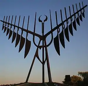 | ||||||
|---|---|---|---|---|---|---|---|
| Politics | |||||||
| Education | |||||||
| Culture | |||||||
| Media |
| ||||||
| Sports | |||||||
| Economy |
| ||||||
| Health | |||||||
| Transportation | |||||||
| Parks | |||||||
List of municipalities in Ontario
| |||||||
| Regions | |
|---|---|
| Counties | |
| Districts | |
| Regional municipalities | |
| Single-tier municipalities | |
| Separated municipalities | |
| |
Great Lakes megaregion as defined by RPA | ||
|---|---|---|
Note: A few Great Lakes regions cities in Canada are left out. Metropolitan areas have +150,000 according to source at the time estimated. | ||
| Great Lakes region cities |  | |
| Surrounding cities |
| |
| Cities of states south of region | ||
| Other metro-regions | ||