Baruva
Baruva is a village and a beach resort located near Sompeta in Srikakulam district, Andhra Pradesh, India. It is located at 18.53N 84.35E.,[2] at an average elevation of 10 m (33 ft). The Mahendratanaya River merges into the Bay of Bengal at this place. This village is situated at a distance of 109 KMs from Srikakulam town, the district headquarters.
Baruva | |
|---|---|
village | |
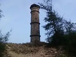 Pillar at Baruva, constructed to commemorate a 1917 shipping accident | |
.svg.png.webp) Baruva Location in Andhra Pradesh, India  Baruva Baruva (India) | |
| Coordinates: 18.882953°N 84.582419°E | |
| Country | |
| State | Andhra Pradesh |
| District | Srikakulam |
| Elevation | 10 m (30 ft) |
| Population | |
| • Total | 5,795 |
| Languages | |
| • Official | Telugu |
| Time zone | UTC+5:30 (IST) |
| PIN | 532263 |
| Vehicle Registration | AP30 (Former) AP39 (from 30 January 2019)[1] |
Baruva was used as a seaport in the era of British colonial rule in India up to 1948. In July, 1917, a ship carrying goods sank in the sea. To commemorate this incident a pillar was constructed.[3] The harbor is closed, but the old lighthouse stood until 2000.
Tourism
- The swampy sea shore, locally called "beela", is well known for duck shooting and fishing.
- The famous Sri Kotilingeswara Swamy and Janardhana Swamy temples are located at this place.
- The river Mahendra Tanya merges into sea at this place. Thousands of people take sea bath during festival days, especilly in "Karthikam" (November-December) every year.
- Baruva was once a seaport. Two obelisks, one white and the other black, of fifty feet height above the sea level, mark the seaport.
- The large grooves of coconut trees and green paddy fields make the place picturesque.
Transport
Baruva railway station is located on Howrah-Chennai mainline. Passenger trains that run from Palasa towards Khurda Road station halt at Baruva station.
References
- "New 'AP 39' code to register vehicles in Andhra Pradesh launched". The New Indian Express. Vijayawada. 31 January 2019. Retrieved 9 June 2019.
- Falling Rain Genomics.Baruva
- A.P.Tourism.Baruva Beach Archived 30 September 2007 at the Wayback Machine
- https://censusindia.gov.in/2011census/dchb/2811_PART_A_DCHB_SRIKAKULAM.pdf
- https://srikakulam.ap.gov.in/eco-tourism/