Benjakitti Park
Benjakitti Park[1] (Thai: สวนเบญจกิติ, RTGS: Benchakitti) is a public park in the Khlong Toei District of central Bangkok; situated next to the Queen Sirikit National Convention Center. It is close to Queen Sirikit National Convention Centre MRT Station, Sukhumvit MRT Station and Asok BTS Station.
| Benjakitti Park | |
|---|---|
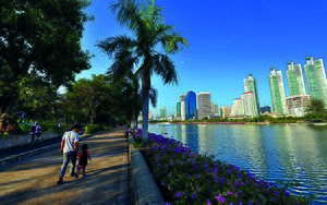 Benchakitti Park, Bangkok | |

| |
| Type | Urban Park |
| Location | Ratchadapisek Road (between Rama IV Road and Sukhumvit Road), Khlong Toei, Bangkok, Thailand |
| Coordinates | 13°43′45.84″N 100°33′30.96″E |
| Area | 52 acres (21 ha) |
| Created | 9 December 2004 |
| Operated by | Bangkok Metropolitan Administration |
| Status | Open from 4.30 a.m. to 21.00 p.m. |
Benjakitti Park was developed from Tobacco pond area 200x800 meters, built by digging and reclamation. This park was part of the project replacement area from resolutions in government of Prime Minister Anand Panyarachun.
Name “Benjakitti” was given by Queen Sirikit during the opening. Benjakitti Park has a landmark symbol called “Pathumthani” near the pond.[2]
It was officially opened in 2004 (on land formally owned by the Tobacco Authority of Thailand) to honour the 72nd birthday of Queen Sirikit.[3] Before that, it has been in operation since 1992, the year the Queen turns 60 (5th cycle), hence the name "Bejakitti" (5 cycles).
Between 1 and 9 December 2014, this park was used for performing theater and a spectacular technique to commemorate His Majesty the King "The Phra Mahathat The Phenomenal Life Show" by the stage in the middle of the pond over 100 meters which is the longest water stage in the country.[4]
After that, the Tobacco Monopoly gave 61 rai (97,600 square meters) more to build Benjakitti forest park to celebrate Her Majesty Queen Sirikit Queen's 7th Birthday Anniversary in 2006, which makes Benjakitti park became the first park in Bangkok which has forest park.[5]
It includes a central boating lake, an outdoor exercise area, a cycling track[6] and a path that is used by walkers and joggers;[7] bicycles and boats can be hired in the park.[8]
The park is bridged to another public park, Lumphini Park by a 1.3 km long elevated pedestrian walkway and bicycle trail at the southwest corner of the park.[9]
References
| Wikimedia Commons has media related to Benjakiti Park. |
- "สวนเบญจกิติ Benchakitti Park". office.bangkok.go.th (in Thai). Archived from the original on August 7, 2017. Retrieved September 19, 2017.
- "เที่ยวสวนกลางเมือง ที่สวนเบญจกิติ". Manager Online. 8 August 2006. Retrieved 2017-11-08.
- "Parks in Sukhumvit". Bangkok.Com.
- "1-9 ธ.ค.นี้ ชมฟรี!!! "พระมหาชนกฯไลฟ์ โชว์" ละครเพลงกลางน้ำสุดอลังการ". Manager Online (in Thai). 30 December 2014. Retrieved 2017-11-08.
- รายงานพิเศษ : สวนป่าเบญจกิติ ปอดใหญ่แห่งใหม่ของคนกรุง, archived from the original on 2017-11-09, retrieved 2017-11-08
- "Bicycle Parks in Bangkok City". Bicycle Thailand.
- "Where to go for a Run in Bangkok". Discover Bangkok.
- "Parks in Sukhumvit". Bangkok.Com.
- "7 เส้นทางลับ ของนักวิ่ง" [7 secret routes of runner]. MiX Magazine (in Thai). Retrieved 2021-01-18.