Berka/Werra
Berka/Werra (also Berka an der Werra) is a town and a former municipality in the Wartburgkreis district, in Thuringia, Germany. Since 1 January 2019, it is part of the town Werra-Suhl-Tal. It is situated on the river Werra, 19 km west of Eisenach.
Berka/Werra | |
|---|---|
Ortsteil of Werra-Suhl-Tal | |
 Coat of arms | |
Location of Berka/Werra 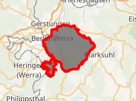
| |
 Berka/Werra 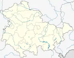 Berka/Werra | |
| Coordinates: 50°56′22″N 10°4′12″E | |
| Country | Germany |
| State | Thuringia |
| District | Wartburgkreis |
| Town | Werra-Suhl-Tal |
| Area | |
| • Total | 56.93 km2 (21.98 sq mi) |
| Elevation | 193 m (633 ft) |
| Population (2017-12-31) | |
| • Total | 4,231 |
| • Density | 74/km2 (190/sq mi) |
| Time zone | UTC+01:00 (CET) |
| • Summer (DST) | UTC+02:00 (CEST) |
| Postal codes | 99837 |
| Dialling codes | 036922 |
| Vehicle registration | WAK |
Within the former municipality there are the following municipal districts:
- Berka/Werra city center
- Fernbreitenbach
- Gospenroda
- Herda (with Hausbreitenbach and Kratzeroda)
- Horschlitt (with Auenheim-Rienau)
- Vitzeroda (with Abteroda and Gasteroda)
- Wünschensuhl
History
Within the German Empire (1871-1918), Berka/Werra was part of the Grand Duchy of Saxe-Weimar-Eisenach.
References
This article is issued from Wikipedia. The text is licensed under Creative Commons - Attribution - Sharealike. Additional terms may apply for the media files.