Blomidon Formation
The Blomidon Formation is a unit of Upper Triassic (Norian–Rhaetian) sedimentary rocks, which outcrops in Nova Scotia. At outcrop they reach a maximum thickness of 365 metres (1,198 ft), but up to 1,168 metres (3,832 ft) has been proven from well data and a thickness of up to 2,500 metres (8,200 ft) has been inferred from seismic reflection data. It overlies the mainly Carnian Wolfville Formation and underlies the North Mountain Basalt.[1] The type section is exposed between Cape Blomidon (45°17′43″N 64°19′55″W) and Paddy Island (45.197372°N 64.359411°W).[2]
| Blomidon Formation Stratigraphic range: Norian-Rhaetian | |
|---|---|
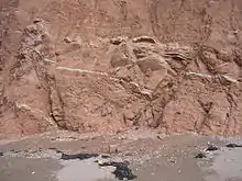 Faulted continental redbeds of the Blomidon Formation, Minas Basin North Shore, Nova Scotia | |
| Type | Geological formation |
| Unit of | Newark Supergroup |
| Underlies | North Mountain Basalt |
| Overlies | Wolfville Formation |
| Thickness | 365–2,500 m (1,198–8,202 ft) |
| Lithology | |
| Primary | Sandstone |
| Other | Mudstone |
| Location | |
| Coordinates | 45°17′43″N 64°19′55″W |
| Region | Nova Scotia |
| Country | Canada |
| Type section | |
| Named for | Cape Blomidon |
| Named by | Klein, 1962 |
References
- Tanner, L.H. (1996). "Formal definition of the Lower Jurassic McCoy Brook Formation, Fundy Rift Basin, eastern Canada". Atlantic Geology. 32: 127–135. Retrieved 15 December 2012.
- Luttrell, Gwendolyn (c. 1989). Geological Survey Bulletin: 1572. U.S. Department of the Interior, Geological Survey.
This article is issued from Wikipedia. The text is licensed under Creative Commons - Attribution - Sharealike. Additional terms may apply for the media files.