Bolshekolpanskoe Rural Settlement
Bolshekolpanskoe Rural Settlement is a rural settlement in Gatchina Municipal District of the Leningrad Oblast (Leningrad Province) in northern Russia. The Bolshekolpanskoe Rural Settlement contains 16 villages.[note 1] The administrative center is the village of Bolshiye Kolpany.
Bolshekolpanskoe Rural Settlement
Большеколпанское сельское поселение | |
|---|---|
.JPG.webp) Church in the village of Malye Kolpany | |
.png.webp) Flag  Coat of arms | |
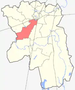 Bolshekolpanskoe Rural Settlement within Gatchina District | |
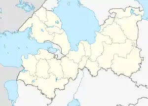 Bolshekolpanskoe Rural Settlement Bolshekolpanskoe Rural Settlement within Leningrad Oblast (Leningrad Province) | |
| Coordinates: 59°31′30″N 30°04′00″E | |
| Country | Russia |
| Province (Oblast) | Leningrad |
| Municipal District | Gatchina |
| Created as (Soviet) village council | 1973 |
| Reconsituted as parish | 1994 |
| Reconstituted as rural settlement | January 1, 2006 |
| Administrative center | Great Kolpany |
| Area | |
| • Total | 157 km2 (61 sq mi) |
| Population (2014) | |
| • Total | 9,782 |
| • Density | 62/km2 (160/sq mi) |
| Time zone | Moscow Time (UTC+03:00) |
| Website | kolpany |
Geography
The Bolshekolpanskoe Rural Settlement is near the center of the Gatchina District, bordered on the north by the Pudostskim Rural Settlement, on the north-east by the Novyi Svet Rural Settlement and the City of Gatchina, on the east by the Kobrin Rural Settlement, on the south by the Roždestvenskoe Rural Settlement, on the south-west by Volosovsky Municipal District, on the west by the Elizavetinskoe Rural Settlement, and on the north-west by the Voyskovitskim Rural Settlement.
The Bolshekolpanskoe Rural Settlement covers 157 square kilometres (61 sq mi). From Great Kolpany to the Gatchina District center is 8.5 kilometres (5.3 mi). The following highways run through the Settlement:
- M20 (R23 highway) which runs from St. Petersburg through Pskov to the Belarussian border. This highway is part of European Route E95 .
- A120 , the St. Petersburg Southern Ring Road, running Serovo – Kirovsk – Bolshaya Izhora
- P-38, running Gatchina – Opole
Geology
The Bolshekolpanskoe Rural Settlement is located on the Izhora Plateau, thus there are very few ponds or lakes in its area. The largest ponds are artificial ones which have resulted from the infilling of stone quarries in Paritsa and Bornitskaya. The Rural Settlement includes the headwaters of Sivoritsky Creek, which joins the Suyda River at the village of Paritsa.
The presence on the plateau of limestone and dolomite, creating a karst landscape, has led to the formation of large karst caves. These caves, which are sealed off from the atmosphere, were used beginning in Soviet times for the storage of natural gas reserves.
History
The area of the Bolshekolpanskoe Rural Settlement was part of the heartland of Ingria, home of the pre-Russian Izhorians and Votes, peoples who are now on the brink of extinction.
In 1973, under the Soviet Union, the Bolshekolpanskoe Village Council was formed as part of the Gatchina District (Gatchina Raion).
On January 18, 1994, by Order Number 10 ("On Changes in the Administrative-Territorial Districts of the Leningrad Region") of the Leningrad Region (Leningrad Oblast), the Bolshekolpanskoe Village Council was redesignated as Bolshekolpanskoe Parish (the other village councils in the District were likewise redesignated by this order).
On January 1, 2006, in accordance with Regional Law Number 133–OZ of December 16, 2004,[1] Bolshekolpanskoe Parish was redesignated as Bolshekolpanskoe Rural Settlement.
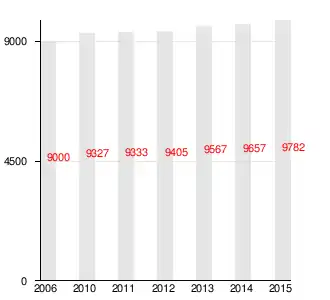
Population
| Year | 2006 | 2010 | 2011 | 2012 | 2013 | 2014 | 2015 |
| Population | 9000 | 9327 | 9333 | 9405 | 9567 | 9657 | 9782 |
Economy
The Bolshekolpanskoe Rural Settlement contains 85 industrial or service enterprises (as of 2015), the largest being the Gatchina Company, which owns more than a third of the Settlement (57.28 square kilometres (22.12 sq mi)) and which is mainly engaged in agricultural production – dairy farming, potatoes, vegetables. The Gatchina Feed Mill, in the village of Malye Kolpany, is one of Russia's largest producers of animal feed.
The caverns in the karst continue to be used to store natural gas. There are also active dolomite quarries. The Settlement also contains various small businesses, engaged in pursuits such as trade, personal services, repair and maintenance of motor vehicles, and so forth. The Sivoritsy Airfield is located in the village of Nikolskoye.
Constituent communities
| Number | Locality | Type of locality | Population (2012) |
|---|---|---|---|
| 1 | Bolshiye Kolpany | Village, administrative center | 4,095 |
| 2 | Vakkolovo | Village | 32 |
| 3 | Vopsha | Village | 156 |
| 4 | Korpisalovo | Village | 122 |
| 5 | Lyadino | Village | 61 |
| 6 | Malye Kolpany | Village | 462 |
| 7 | Nikolskoye | Village (Selo) | 2,882 |
| 8 | New Koleno | Village | 31 |
| 9 | New Hinkolovo | Village | 20 |
| 10 | New Chernitsov | Village | 46 |
| 11 | Paritsa | Village | 243 |
| 12 | Rotkovo | Village | 39 |
| 13 | Old Hinkolovo | Village | 25 |
| 14 | Old Chernitsov | Village | 29 |
| 15 | Tihkovitsy | Village | 241 |
| 16 | Himozi | Village | 425 |
References
- Legislative Assembly of Leningrad Oblast (December 16, 2004). "Областной закон Ленинградской области от 16.12.2004 N 113-оз – Об установлении границ и наделении соответствующим статусом муниципального образования Гатчинский муниципальный район и муниципальных образований в его составе" [Regional Law of Leningrad region from 16.12.2004 N 113-OZ - On Establishing the Borders and Granting an Appropriate Status to Gatchina Municipal District and its Constituent Municipalities]. Bestpravo.com. Archived from the original on August 8, 2016. Retrieved February 18, 2016. (in Russian)
Notes
- Actually the village of Nikolskoye is a selo (Russian: село), the others are villages (Russian: деревня); both terms translate to "village", the traditional difference being that selos have a church. The village of Great Kolpany, with a population over 4,000 (2012) would usually be called a "town" in most of the English-speaking world, but Russian does not distinguish between cities and towns (both are called "gorod" (Russian: город)) and criteria for town/city status is higher (12,000 inhabitants, usually).