Bowbeat Hill
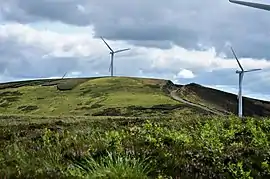
Bowbeat Hill is a hill in the Moorfoot Hills range, part of the Southern Uplands of Scotland. It lends its name to Bowbeat Onshore Wind Farm built on the hill and commissioned in 2003. The wind farm produces 31.2MW of power using 24 turbines.[3] It is commonly ascended with its neighbouring hills from Gladhouse Reservoir to the north.[1]
| Bowbeat Hill | |
|---|---|
 | |
| Highest point | |
| Elevation | 626 m (2,054 ft) [1] |
| Prominence | 79 m (259 ft) [1] |
| Listing | Tu,Sim, D,GT,DN[2] |
| Coordinates | 55°42′38″N 3°07′40″W |
| Geography | |
| Location | Scottish Borders, Midlothian, Scotland |
| Parent range | Moorfoot Hills, Southern Uplands |
| Topo map | OS Landranger 73 |
References
- "Bowbeat Hill". www.hill-bagging.co.uk.
- "Database of British and Irish Hills: user guide". www.hills-database.co.uk.
- "Bowbeat onshore wind farm". www.group.rwe.
This article is issued from Wikipedia. The text is licensed under Creative Commons - Attribution - Sharealike. Additional terms may apply for the media files.