Brent, Ontario
Brent is a community on Cedar Lake on the Petawawa River in northern Algonquin Provincial Park, and is located in geographic Deacon Township in the Unorganized south part of Nipissing District in Northeastern Ontario, Canada.[2]
Brent | |
|---|---|
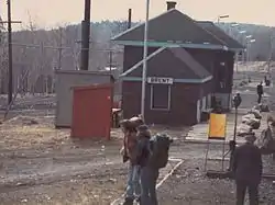 Arriving by train CNR Brent, Ontario, in the 1970s | |
| Etymology: Named for Brentwood, England | |
 Brent Location of Brent in Ontario | |
| Coordinates: 46°01′48″N 78°28′51″W | |
| Country | Canada |
| Province | Ontario |
| Region | Northeastern Ontario |
| District | Nipissing |
| Part | Nipissing, Unorganized South |
| Elevation | 315 m (1,033 ft) |
| Population (2016)[1] | |
| • Total | 0 |
| Time zone | UTC-5 (Eastern Time Zone) |
| • Summer (DST) | UTC-4 (Eastern Time Zone) |
| Postal code FSA | K0J |
| Area code(s) | 705, 249 |
It was originally a station and divisional point on the transcontinental main line of the Canadian Northern Railway, and was named for Brentwood, England, the home of Robert M. Horne-Payne, a director of the Canadian Northern. During the late 19th and early 20th century, a number of lumber companies operated at Brent. It later became a Canadian National Railway divisional point between the CN Alderdale Subdivision to the west and the CN Beachburg Subdivision to the east; the next railway points were Government Park to the west and Acanthus to the east. In 1995, Canadian National Railways decided to close the Northern Algonquin line to rail traffic, stating that operational costs were too high. As part of the closure the Brent rail yard was dismantled along with the yards' twin 125 KW generators that supplied power to Brent. Brent is too remote to be connected to the main hydro power grid so the remaining dwellings requiring power use either generator, solar or use no power at all.
The Brent village at its peak, circa 1930, had a school house, hotel, restaurant, post office, train station, round house, coal tower, water tower, saw mill and houses to accommodate around 200 people both railway and saw mill employees.
Brent today is essentially a recreational camp site with some park services and is an access point to the interior of Algonquin Park (Brent access point). Brent operates seasonally with no permanent population. The village of Brent consists of 17 seasonal dwellings 14 of which are located in the east end (the rail yard) and the 3 in the west end (logging mill). A well preserved ranger station and deputy ranger station are located on the peninsula found at the easternmost edge of the village. There is also a graveyard located beside the present day westernmost campsite number 2. There is no telephone or cellular phone access as it is too far to connect to the telephone system and is out of range of any cellular network. For travelers driving to Brent be sure to fill up your vehicle at Mattawa, from the west, or Stonecliffe, from the east, before making the voyage as there is not a fuel station close by (nearest is Mattawa 100 km away). Fuel in Brent is roughly $4.00 to $5.00 per litre, when available, at the Brent Store. Brent is a no smoking village.
The Brent crater is located north of the village.
References
- 2016 Canada Census population for block 35480228230
- "Brent". Geographical Names Data Base. Natural Resources Canada. Retrieved 2011-07-25.
Other map sources:
- McMurtrie, Jeffrey (2008). "Algonquin Provincial Park and the Haliburton Highlands". Wikimedia Commons. Archived from the original on 2011-06-29. Retrieved 2011-08-10.
- Map 9 (PDF) (Map). 1 : 700,000. Official road map of Ontario. Ministry of Transportation of Ontario. 2010-01-01. Retrieved 2011-08-10.
- Restructured municipalities - Ontario map #5 (Map). Restructuring Maps of Ontario. Ontario Ministry of Municipal Affairs and Housing. 2006. Retrieved 2011-08-10.
Gallery
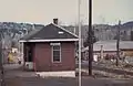 Brent station west side as seen from a train in the 1970s
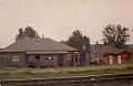 Brent Store in the 1970s. Note: Petrol pumps are no longer present.
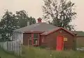 Brent One Room Schoolhouse, Brent, Ontario
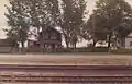 unidentified building, Brent, Ontario
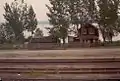 unidentified building, Brent, Ontario
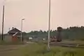 Railway yard and Brent Station, looking west in the 1970s
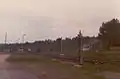 Railway yard and Brent Station, looking west in the 1970s
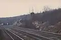 Brent railway yard as seen from a passing train in springtime early 1970s