Brunnadern
Brunnadern is a village in the municipality of Neckertal in the Wahlkreis (constituency) of Toggenburg in the canton of St. Gallen in Switzerland.
Brunnadern | |
|---|---|
_234.JPG.webp) | |
 Coat of arms | |
Location of Brunnadern 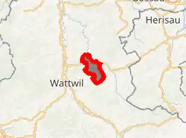
| |
 Brunnadern Brunnadern | |
| Coordinates: 47°20′N 9°8′E | |
| Country | Switzerland |
| Canton | St. Gallen |
| District | Toggenburg |
| Municipality | Neckertal |
| Area | |
| • Total | 6.69 km2 (2.58 sq mi) |
| Elevation | 660 m (2,170 ft) |
| Population (January 2004) | |
| • Total | 893 |
| • Density | 130/km2 (350/sq mi) |
| Time zone | UTC+01:00 (Central European Time) |
| • Summer (DST) | UTC+02:00 (Central European Summer Time) |
| Postal code(s) | 9125 |
| SFOS number | 3371 |
| Website | www SFSO statistics |
Brunnadern was an independent municipality until January 1, 2009, when it merged with Mogelsberg and St. Peterzell to form the municipality of Neckertal.[1]
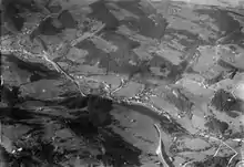
Aerial view from 1800 m by Walter Mittelholzer (1923)
See also
References
- Amtliches Gemeindeverzeichnis der Schweiz published by the Swiss Federal Statistical Office (in German) accessed 14 January 2010
External links
- Official website (in German)
- Brunnadern in German, French and Italian in the online Historical Dictionary of Switzerland.
| Wikimedia Commons has media related to Brunnadern. |
This article is issued from Wikipedia. The text is licensed under Creative Commons - Attribution - Sharealike. Additional terms may apply for the media files.