Buckeye Creek (West Virginia)
Buckeye Creek is a tributary of Middle Island Creek, 12.7 miles (20.4 km) long,[3] in north-central West Virginia in the United States. Via Middle Island Creek and the Ohio River, it is part of the watershed of the Mississippi River, draining an area of 39.1 square miles (101 km2)[4] in a rural region on the unglaciated portion of the Allegheny Plateau.
| Buckeye Creek | |
|---|---|
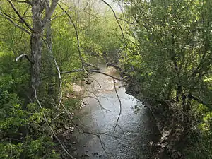 Buckeye Creek east of Smithburg, West Virginia | |
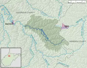 Buckeye Creek and its watershed | |
| Location | |
| Country | United States |
| State | West Virginia |
| County | Doddridge |
| Physical characteristics | |
| Source | |
| • location | northeast of Miletus |
| • coordinates | 39.2456437°N 80.5645416°W[1] |
| • elevation | 1,145 ft (349 m)[2] |
| Mouth | Middle Island Creek |
• location | Smithburg |
• coordinates | 39.2842512°N 80.7281587°W[1] |
• elevation | 794 ft (242 m)[1] |
| Length | 12.7 mi (20.4 km) |
| Basin size | 39.1 sq mi (101 km2) |
| Basin features | |
| Hydrologic Unit Code | 050302010402 (USGS) |
Buckeye Creek's course is entirely in Doddridge County. It rises near the boundary of Doddridge and Harrison counties, approximately 1.6 miles (2.6 km) northeast of the unincorporated community of Miletus, and flows generally west-northwestward, through Miletus and the unincorporated communities of Zinnia, Nina, and Sherwood. Downstream of Sherwood, the stream is largely paralleled by U.S. Route 50 and the North Bend Rail Trail. It joins the Meathouse Fork to form Middle Island Creek at the community of Smithburg.[5][6]
According to the Geographic Names Information System, Buckeye Creek has also been known historically by the name "Buckey Fork."[1]
See also
References
- Geographic Names Information System. "Geographic Names Information System entry for Buckeye Creek (Feature ID #1536586)". Retrieved 2013-08-09.
- The National Map elevation for GNIS source coordinates. Retrieved 2013-08-09.
- United States Environmental Protection Agency. "West Virginia, Little Muskingum-Middle Island Watershed". Archived from the original on 2011-10-15. Retrieved 2013-08-09.
- U.S. Geological Survey. National Hydrography Dataset, area data for Buckeye Creek watershed, 12-digit Hydrologic Unit Code 050302010402. The National Map Archived 2012-04-05 at WebCite, retrieved 2013-08-09
- The National Map Archived 2012-04-05 at WebCite, accessed 2013-08-09
- West Virginia Atlas & Gazetteer. Yarmouth, Me.: DeLorme. 1997. pp. 24, 35. ISBN 0-89933-246-3.