Cacheu River Mangroves Natural Park
The Cacheu River Mangroves Natural Park (Portuguese: Parque Natural dos Tarrafes do Rio Cacheu) is a national park[2] situated on the Cacheu River in Guinea-Bissau. It was established on 1 December 2000. This site is 886 km2.[3] The park has been designated as a Ramsar site since 2015.[1]
| Cacheu River Mangroves Natural Park | |
|---|---|
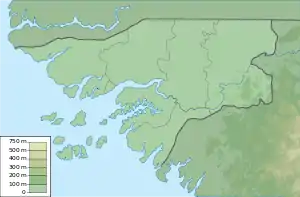 | |
| Location | Guinea-Bissau |
| Coordinates | 12°17′54″N 16°11′59″W |
| Area | 886 km2 (342 sq mi) |
| Established | 2000 |
| Designations | |
|---|---|
| Official name | Parc Naturel des Mangroves du Fleuve Cacheu (PNTC) |
| Designated | 22 May 2015 |
| Reference no. | 2229[1] |
The park is considered to be the largest compact mangrove environment in West Africa, as much as 68% of the territory is covered with mangroves.
Under the protection of mangroves, the reproduction of fishing resources and the preservation of the diversity of flora and fauna are ensured. The park provides a home for many migratory birds in the region.[4]
External links
References
- "Parc Naturel des Mangroves du Fleuve Cacheu (PNTC)". Ramsar Sites Information Service. Retrieved 25 April 2018.
- "Guinea Bissau National Park". Bissautourism.com: Guinea Bissau: 88 Heavenly Inhabited Islands. Archived from the original on 7 April 2015. Retrieved 16 November 2015.
- World Database on Protected Areas
- "National park of cacheu river mangroves - Réseau Régional d'Aires Marines Protégées en Afrique de l'Ouest". www.rampao.org. Retrieved 2020-09-21.
| Authority control |
|---|
This article is issued from Wikipedia. The text is licensed under Creative Commons - Attribution - Sharealike. Additional terms may apply for the media files.