Cadell County

Cadell County is one of the 141 Cadastral divisions of New South Wales. It contains the city of Moama.

Cadell
New South Wales
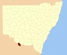
Location in New South Wales
Lands administrative divisions around Cadell:
Wakool Townsend Townsend
Wakool Cadell Townsend
Gunbower (Vic) Rodney (Vic) Moira (Vic)

Cadell County was named in honour of Francis Cadell (1822-1879), river navigator and entrepreneur[1] who in 1852, in preparation for the launch of his steamer service, explored the Murray river in a canvas boat, travelling 1,300 miles (2,100 km) downstream from Swan Hill.[2]


Parishes within this county

A full list of parishes found within this county; their current LGA and mapping coordinates to the approximate centre of each location is as follows:

ParishLGACoordinates
BamaMurray River Council36°00′54″S 144°51′04″E
BenarcaMurray River Council35°57′54″S 144°38′04″E
BunnalooMurray River Council35°45′54″S 144°41′04″E
BurrumburyMurray River Council35°49′54″S 144°25′04″E
CaldwellMurray River Council35°39′54″S 144°28′04″E
CaloolaMurray River Council36°00′54″S 144°44′04″E
CaloolaMurray River Council35°59′54″S 144°43′04″E
GothaMurray River Council35°37′54″S 144°35′04″E
GothogMurray River Council35°40′54″S 144°41′04″E
GulpaMurray River Council35°50′54″S 144°51′04″E
MarahMurray River Council35°33′54″S 144°29′04″E
MarsMurray River Council35°53′54″S 144°39′04″E
MathouraMurray River Council35°45′54″S 144°46′04″E
MoamaMurray River Council36°03′54″S 144°48′04″E
MoiraMurray River Council35°55′54″S 144°49′04″E
NallamMurray River Council35°49′54″S 144°46′04″E
PerricootaMurray River Council35°57′54″S 144°33′04″E
PortholeMurray River Council35°35′54″S 144°21′04″E
TamarMurray River Council35°48′54″S 144°34′04″E
TantonanMurray River Council35°42′54″S 144°23′04″E
TatailaMurray River Council36°02′54″S 144°42′04″E
ThuleMurray River Council35°37′54″S 144°24′04″E
ThyraMurray River Council35°49′54″S 144°41′04″E
TomaraMurray River Council35°49′54″S 144°28′04″E
ToorangabbyMurray River Council35°54′54″S 144°28′04″E
WirringanMurray River Council35°40′54″S 144°35′04″E
WombootaMurray River Council35°53′54″S 144°33′04″E
WongalMurray River Council35°44′54″S 144°35′04″E
YarramanMurray River Council35°45′54″S 144°30′04″E

References

  1. "Cadell County". Geographical Names Register (GNR) of NSW. Geographical Names Board of New South Wales.
  2. "Present condition and prospects of south australia". South Australian Register. 14 September 1852. p. 1S. Retrieved 4 November 2010.
This article is issued from Wikipedia. The text is licensed under Creative Commons - Attribution - Sharealike. Additional terms may apply for the media files.