Cadia, New South Wales
Cadia is a locality in the Cabonne Shire of New South Wales, Australia. It was formerly a private township established c. 1860s by the Cadiangullong Consolidated Copper company.[2] It is now part of the Cadia-Ridgeway Mine lease, operated by Newcrest Mining.[3] It had a population of zero as of the 2016 census.[1]
| Cadia New South Wales | |
|---|---|
Cadia | |
| Coordinates | 33°27′00″S 148°59′00″E |
| Population | 0 (2016 census)[1] |
| Postcode(s) | 2800 |
| Location | 20 km (12 mi) SW of Orange |
| LGA(s) | Cabonne Shire |
| State electorate(s) | Orange |
| Federal Division(s) | Calare |
History
The Wiradjuri people are the traditional owners of the land around Cadia, the area now known as the Cadia Valley.[4]
In the 1860s, mines were opened on either side of Cadiangullong Creek, which flows through the valley into the Belubula River. Cadia developed on its eastern bank,[5] near what became the main crossing of the creek,[6] downstream of the confluence of Cadiangullong Creek with its tributary, Cadia Creek, formerly Rodd's Creek.[7] The first phase of copper mining ended in 1868, resuming again at 'Iron Duke,' the hill also known as 'Big Cadia', between 1882 and 1898.[8]
From around the start of new copper mining activity, in 1905, the centre of settlement at Cadia moved northward and uphill, toward the underground copper mine workings, at the location known 'Iron Duke', and closer to the road to Orange. Chillcott Street became its main street.[6][9] From 1905 to 1917, 5,000 tons of copper metal were obtained from 100,000 tons of ore mined at Cadia.[10]
.jpg.webp)
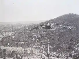
From 1918 to 1929, 1,682,000 tons of iron ore was mined at Cadia from a surface deposit at 'Iron Duke'. The ore was shipped over a privately operated railway branch line that joined the main line at Spring Hill.[10][11] The railway line ended on the eastern side of the creek. Iron ore was carried downhill in skips via an inclined tramway, then across the valley by an aerial ropeway to bins, where it was loaded into rail wagons and sent to Lithgow.[12][13] Iron ore mining at Cadia ended soon after the relocation of blast furnace operations from Lithgow to Port Kembla in late 1928.[14][15][16]The iron ore mine was the site of a disastrous accident on 10 March 1921 in which nine miners were killed in an explosion.[17][18]
The 1920s saw the town at its greatest population and extent. In 1925, the population reached 300. However, once the iron mine closed in 1929, its decline was rapid.[6][19] Cadia Public School, which had opened in December 1865, closed in May 1930.[20] Cadia Post Office, which opened on 1 August 1864, closed on 29 March 1935.[21] By 1940, just the old school building and two residences survived.[22]
When the 'Iron Duke' iron ore mine was re-opened in late 1942, during the Second World War,[10] new staff housing had to be built and a temporary 'tent city' established for the workers.[23] In 1945, mining ceased and Cadia was abandoned. Cadia Public School, which had reopened in January 1943, closed permanently in May 1945.[20] In June 1945, forty buildings at the site were auctioned.[24] All buildings in Cadia subsequently were removed or destroyed; the entire village reverted to paddocks. Old Cadia Road still follows the alignment of Chilcott Street, the old main street.[6]
Although mining had taken place in the vicinity for well over a century, it was not until 1992 that the porphyry gold-copper potential of the district was recognised by geologists of Newcrest Mining Limited. Enormous tonnages of ore-grade mineralisation were identified, resulting in the huge open-cut mine and two nearby underground mines now in operation.[25]
The enormous scale of the modern mines has led to the relocation of some artifacts of Cadia's history and cultural heritage, including a scarred tree[4]and the former village's cemetery.[26]
References
- Australian Bureau of Statistics (27 June 2017). "Cadia (State Suburb)". 2016 Census QuickStats. Retrieved 16 November 2017.

- "Extract". Geographical Names Board of New South Wales. Retrieved 20 June 2018.
- "1860s". Cadia Valley Heritage. Archived from the original on 20 February 2017. Retrieved 20 June 2018.
- "Aboriginal Prehistory". Newcrest Mining Limited. Retrieved 9 August 2020.
- "Cadia, NSW | Central New South Wales Museums". www.centralnswmuseums.com.au. Retrieved 8 August 2020.
- "Cadia Village – archaeological investigations, 2002". Newcrest Mining Limited. Retrieved 9 August 2020.
- "Parish of Waldegrave, County of Bathurst [cartographic material] : Land Districts of Blayney & Orange, Lyndhurst & Canobolas Shires". Trove. Retrieved 15 August 2020.
- "PorterGeo Database - Ore Deposit Description". www.portergeo.com.au. Retrieved 9 August 2020.
- "Mining' at Cadia". Australian Town and Country Journal (Sydney, NSW : 1870 - 1907). 21 August 1907. p. 37. Retrieved 6 October 2020.
- "IRON ORE WINNING AT THE IRON DUKE, CADIA, N.S.W." Daily Commercial News and Shipping List (Sydney, NSW : 1891 - 1954). 16 January 1943. p. 2. Retrieved 18 June 2020.
- "Cadia Mine Branch". www.nswrail.net. Retrieved 9 August 2020.
- "THE LINE TO CADIA". Leader (Orange, NSW : 1899 - 1945). 9 September 1918. p. 5. Retrieved 14 August 2020.
- "CADIA, IN THE VALLEY by "KENSO"". Labor Daily (Sydney, NSW : 1924 - 1938). 2 February 1928. p. 8. Retrieved 12 August 2020.
- "QUARRY CLOSES DOWN". Lithgow Mercury (NSW : 1898 - 1954). 12 October 1928. p. 8. Retrieved 12 August 2020.
- "CADIA QUARRY". Leader (Orange, NSW : 1899 - 1945). 2 November 1928. p. 8. Retrieved 12 August 2020.
- "BLAST FURNACE CLOSES". Lithgow Mercury (NSW : 1898 - 1954). 21 November 1928. p. 1. Retrieved 12 August 2020.
- Beauchamp, Clive (October 2012). "Disaster at Hoskins' Ironstone Quarry, Cadia, Orange, 1921" (PDF) – via Journal of Australasian Mining History, Volume 10.
- "CADIA DISASTER. - FACE SPLIT OFF CLIFF. HOW THE CHARGE WAS LAID. DISTRICT IN MOURNING. - The Daily Telegraph (Sydney, NSW : 1883 - 1930) - 12 Mar 1921". Trove. Retrieved 18 June 2020.
- "CADIA MINING PRECINCT Archaeologjcal Assessment - Volume V, Report Prepared for Newcrest Mining Limited" (PDF). January 1995. p. 29.
- "Cadia". School history database search. NSW Department of Education. Retrieved 20 June 2018.
- "Cadia". Post Office Reference. Premier Postal. Retrieved 28 June 2018.
- "CADIA "RUINS."". Sydney Morning Herald (NSW : 1842 - 1954). 28 September 1940. p. 9. Retrieved 9 August 2020.
- "Closer settlement of the Landscape, 1860s onwards". Newcrest Mining Limited. Retrieved 9 August 2020.
- "AUCTION SALE OF 40 BUILDINGS ETC". National Advocate (Bathurst, NSW : 1889 - 1954). 29 May 1945. p. 3. Retrieved 13 August 2020.
- Wilson, Alan J. (November 2003). "The geology, genesis and exploration context of the Cadia gold-copper porphyry deposits, New South Wales, Australia" (PDF). University of Tasmania.
- "Cadia Cemetery, 1864-1927". Newcrest Mining Limited. Retrieved 9 August 2020.
- "Cadia Engine House & Surrounds". New South Wales State Heritage Register. Office of Environment and Heritage. H00779. Retrieved 18 May 2018.