California State Route 192
State Route 192 (SR 192) is a state highway in the U.S. state of California. The route runs from State Route 154 near Santa Barbara to State Route 150 near the Santa Barbara–Ventura county line. The two-lane road is better known as Foothill Road, as the route runs parallel to the foothills of the Santa Ynez Mountains.
| ||||
|---|---|---|---|---|
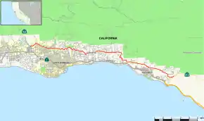 Map of Santa Barbara County in southern California with SR 192 highlighted in red | ||||
| Route information | ||||
| Defined by Streets and Highways Code § 492 | ||||
| Maintained by Caltrans | ||||
| Length | 21.043 mi[1] (33.865 km) | |||
| Major junctions | ||||
| West end | ||||
| East end | ||||
| Location | ||||
| Counties | Santa Barbara | |||
| Highway system | ||||
| ||||

Route description
The western terminus is at State Route 154 in Santa Barbara at the intersection of San Marcos Pass Road, Cathedral Oaks Road, and Foothill Road. It runs east on Foothill Road, Mountain Drive, Stanwood Drive, Sycamore Canyon Road, East Valley Road, Toro Canyon Road, Foothill Road, then Casitas Pass Road. The eastern terminus is at State Route 150 near the Ventura/Santa Barbara County line at the intersection of Casitas Pass Road and Rincon Road.
The western portion of SR 192 is part of the National Highway System,[2] a network of highways that are considered essential to the country's economy, defense, and mobility by the Federal Highway Administration.[3]
History
This route was originally part of State Route 150, which was signed in 1934. It was renumbered to Route 192 in 1964.
Major intersections
Except where prefixed with a letter, postmiles were measured on the road as it was in 1964, based on the alignment that existed at the time, and do not necessarily reflect current mileage. R reflects a realignment in the route since then, M indicates a second realignment, L refers an overlap due to a correction or change, and T indicates postmiles classified as temporary (for a full list of prefixes, see the list of postmile definitions).[1] Segments that remain unconstructed or have been relinquished to local control may be omitted. The entire route is in Santa Barbara County.
| Location | Postmile [1][4][5] | Destinations | Notes | ||
|---|---|---|---|---|---|
| | 0.00 | Cathedral Oaks Road | Continuation beyond SR 154 | ||
| | 0.00 | Interchange; west end of SR 192 | |||
| Santa Barbara | 6.17 | Intersection near Parma Park | |||
| | 21.17 | East end of SR 192 | |||
1.000 mi = 1.609 km; 1.000 km = 0.621 mi
| |||||
See also
 California Roads portal
References
- California Department of Transportation. "State Truck Route List". Sacramento: California Department of Transportation. Archived from the original (XLS file) on June 30, 2015. Retrieved June 30, 2015.
- Federal Highway Administration (March 25, 2015). National Highway System: Santa Barbara, CA (PDF) (Map). Scale not given. Washington, DC: Federal Highway Administration. Retrieved September 16, 2017.
- Natzke, Stefan; Neathery, Mike & Adderly, Kevin (June 20, 2012). "What is the National Highway System?". National Highway System. Washington, DC: Federal Highway Administration. Retrieved July 1, 2012.
- California Department of Transportation (July 2007). "Log of Bridges on State Highways". Sacramento: California Department of Transportation.
- California Department of Transportation, All Traffic Volumes on CSHS, 2005 and 2006
External links
| Wikimedia Commons has media related to California State Route 192. |