Canton of Fribourg
The canton of Fribourg, also canton of Friburg (French: canton de Fribourg, French pronunciation: [kɑ̃ˈtõ dœ fχiˈbuʁ], German: Kanton ![]() Freiburg ) is located in western Switzerland. The canton is bilingual, with French spoken by two thirds of the citizens and German by about one third.[3] Both are official languages in the canton. The canton takes its name from its capital city of Fribourg.
Freiburg ) is located in western Switzerland. The canton is bilingual, with French spoken by two thirds of the citizens and German by about one third.[3] Both are official languages in the canton. The canton takes its name from its capital city of Fribourg.
Canton de Fribourg Kanton Freiburg | |
|---|---|
 Flag 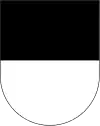 Coat of arms | |
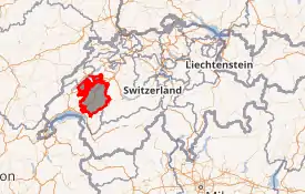
Location in Switzerland
Map of Fribourg 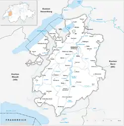 | |
| Coordinates: 46°43′N 7°5′E | |
| Capital | Fribourg/Freiburg |
| Subdivisions | 168 municipalities, 7 districts |
| Government | |
| • Executive | Conseil d'Etat/Staatsrat (7) |
| • Legislative | Grand Council of Fribourg (130) |
| Area | |
| • Total | 1,671.42 km2 (645.34 sq mi) |
| Population (December 2019)[2] | |
| • Total | 321,783 |
| • Density | 190/km2 (500/sq mi) |
| ISO 3166 code | CH-FR |
| Highest point | 2,389 m (7,838 ft): Vanil Noir |
| Lowest point | 429 m (1,407 ft): shore Lake Neuchâtel |
| Joined | 1481 |
| Languages | French, German |
| Website | www |
History
On the shores of Lake Neuchâtel and Lake Morat significant traces of prehistoric settlements have been unearthed.
The canton of Fribourg joined the Swiss Confederation in 1481. The area is made up of lands acquired by the capital Fribourg. The present extent was reached in 1803 when Murten (Morat) was acquired. The canton of Fribourg joined the separatist league of Catholic cantons in 1846 (Sonderbund). The following year, its troops surrendered to the federal army.
Geography
_Vanil_Noir_(hinten).jpg.webp)
The canton is bounded to the west by Lake Neuchâtel, to the west and the south by the canton of Vaud, and to the east by the canton of Bern. The canton includes two enclaves within Vaud and one within the canton of Bern, as well as a large exclave on the lake. The area of the canton is 1,669 square kilometers (644.4 sq mi), including the small enclaves.
The canton lies on the elevated Swiss Plateau. In the west the lands are flat, but towards the south east of the canton, the lands rise to a hilly region. This region is commonly called pre-Alps but is part of the Bernese Alps. The highest elevation in the canton is the Vanil Noir with 2,389 m (7,838 ft).
The river Saane/Sarine flows from the south to the north of the canton. Together with its tributaries it drains most of the lands in the canton, then joins the river Aare. The river Broye drains the west of the canton and flows northeast into Lake Morat (Murtensee). The southwest part of the canton is drained by the river Veveyse, which flows south into Lake Geneva (French: Le Léman).
Political subdivisions
Districts
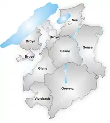
The Canton is divided into seven districts:
Municipalities
There are 165 municipalities in the canton of Fribourg as of January 2012. The number is decreasing as the canton subsidizes mergers between municipalities.
Demographics
In contrast to the mainly Protestant cantons of Vaud to its west and Bern to its east, the canton of Fribourg is a predominantly Roman Catholic enclave (as of 2000, 70%) with a Protestant minority (15%).[4] This explains the canton's existence, even though it straddles the French-German linguistic border, for in the past, denominational considerations were more important than linguistic when drawing Switzerland's cantons.
The main centres of population are the capital Fribourg (34,300 inhabitants) and Bulle (18,200 inhabitants).
Two thirds of the population speak French, the remainder speak Alemannic dialects of German. The French-speaking areas are in the west of the canton, the Alemannic-speaking areas in the east. The number of bilingual towns, and consequently the large number of people who can speak both French and German fluently, has attracted businesses such as telesales companies. The population of the canton (as of 31 December 2019) is 321,783.[2] As of 2007, the population included 43,838 foreign-born residents, or about 16.65% of the total population.[5]
Economics
Agriculture is important in the canton of Fribourg. The main agricultural activities are cattle breeding and dairy farming. The region is a major cheese producer, especially the district of Gruyère, home of the cheese of the same name. The chocolate industry is also well established in Broc, home to an international chocolate research centre.[6] Other agricultural produces include tobacco, fruit and cereals. Agriculture is predominant in the north of the canton where the most fertile lands lie.
There is light industry concentrated around the capital Fribourg. Other centres of light industry are Bulle, Villars-sur-Glâne, Düdingen (Guin), Murten (Morat) and Estavayer-le-Lac. These five centers have also a large number of established small and medium-sized businesses, many of which are in the service sector. Forests are important in the La Gruyère (Greyerz) district.
Power plants in the district of Sarine export electricity. The mountain areas attract tourists all year round. The lake regions are frequented by tourists in summer and autumn.
Transport
The canton of Fribourg is well connected to other areas of Switzerland with motorways A1, A12 and fast rail links. The main railway between Geneva and Lausanne in the south west to Bern and Zürich connects Fribourg with other centres of the country.
Politics
Federal election results
| Percentage of the total vote per party in the canton in the Federal Elections 1971-2015[7] | ||||||||||||||
|---|---|---|---|---|---|---|---|---|---|---|---|---|---|---|
| Party | Ideology | 1971 | 1975 | 1979 | 1983 | 1987 | 1991 | 1995 | 1999 | 2003 | 2007 | 2011 | 2015 | |
| FDP.The Liberalsa | Classical liberalism | 24.7 | 22.1 | 23.0 | 20.0 | 16.7 | 16.1 | 15.9 | 14.8 | 12.8 | 13.8 | 12.8 | 14.2 | |
| CVP/PDC/PPD/PCD | Christian democracy | 41.5 | 46.9 | 39.9 | 38.0 | 37.7 | 36.8 | 36.0 | 33.7 | 25.4 | 24.8 | 20.3 | 22.7 | |
| SP/PS | Social democracy | 19.9 | 25.7 | 30.7 | 24.0 | 22.2 | 18.6 | 17.3 | 20.3 | 21.5 | 22.7 | 26.7 | 24.2 | |
| SVP/UDC | Swiss nationalism | 8.7 | 4.3 | 6.4 | 8.8 | 8.9 | 9.7 | 8.3 | 11.4 | 21.4 | 22.0 | 21.4 | 25.9 | |
| EVP/PEV | Christian democracy | *b | * | * | * | * | * | * | * | 0.7 | 0.8 | 0.7 | 0.7 | |
| CSP/PCS | Christian socialism | 5.3 | * | * | 7.5 | 6.9 | 7.7 | 8.7 | 10.9 | 10.4 | 7.1 | 5.5 | 1.8 | |
| GLP/PVL | Green liberalism | * | * | * | * | * | * | * | * | * | * | 3.5 | 3.2 | |
| BDP/PBD | Conservatism | * | * | * | * | * | * | * | * | * | * | 1.9 | 1.3 | |
| PdA/PST-POP/PC/PSL | Socialism | * | * | * | * | * | * | 0.9 | * | * | * | * | * | |
| GPS/PES | Green politics | * | * | * | * | 4.2 | c | 2.3 | * | 4.0 | 6.3 | 5.0 | 5.3 | |
| FGA | Feminist | * | * | * | * | 1.7 | c | * | * | * | * | * | * | |
| SD/DS | National conservatism | * | * | * | * | * | 1.4 | 0.9 | 0.3 | * | * | * | * | |
| EDU/UDF | Christian right | * | * | * | * | * | * | * | * | 0.7 | 0.9 | 0.7 | 0.8 | |
| Other | * | 1.0 | * | 1.7 | 1.9 | 9.6 | 9.7 | 8.6 | 3.1 | 1.6 | 1.5 | * | ||
| Voter participation % | 53.5 | 47.7 | 48.6 | 52.9 | 46.3 | 45.0 | 39.5 | 41.2 | 45.4 | 48.0 | 47.2 | 47.2 | ||
Notes and references
- Arealstatistik Land Cover - Kantone und Grossregionen nach 6 Hauptbereichen accessed 27 October 2017
- "Ständige und nichtständige Wohnbevölkerung nach institutionellen Gliederungen, Geburtsort und Staatsangehörigkeit". bfs.admin.ch (in German). Swiss Federal Statistical Office - STAT-TAB. 31 December 2019. Retrieved 6 October 2020.
- "Annuaire statistique du canton de Fribourg – Statistisches Jahrbuch des Kantons Freiburg – 2014" (PDF; 8,95 MB) (in French and German). Fribourg, Switzerland: Amt für Statistik des Staates Freiburg. Retrieved 2014-08-05.
- Federal Department of Statistics (2004). "Wohnbevölkerung nach Religion". Archived from the original (Interactive Map) on 2016-09-24. Retrieved 2009-01-15.
- Federal Department of Statistics (2008). "Ständige Wohnbevölkerung nach Staatsangehörigkeit, Geschlecht und Kantonen". Archived from the original (Microsoft Excel) on December 15, 2008. Retrieved November 5, 2008.
- "Nestle to launch personalized luxury chocolates". reuters.com. Reuters. 2011-10-20. Retrieved 2017-08-23.
- Nationalratswahlen: Stärke der Parteien nach Kantonen (Schweiz = 100%) (Report). Swiss Federal Statistical Office. 2015. Archived from the original on 2016-08-02. Retrieved 2016-08-05.
External links
| Wikimedia Commons has media related to Canton of Fribourg. |
- Official site (in French and German)
- Official statistics
| Authority control |
|---|