Cape Liptrap
Cape Liptrap is located in south Gippsland, Victoria and is a peninsula that is the extension of the Hoddle Range that runs out to sea in a southwesterly direction. With a latitude of 38° 53' 60" S it the second most southerly point on the Australian mainland, just south of Cape Otway which lies to the west. Wilsons Promontory which is the most southerly point sits to the southeast separated from Cape Liptrap by Waratah Bay.
.jpg.webp)
It was sighted by Lieutenant James Grant on 9 December 1800 from the survey brig HMS Lady Nelson and named after John Liptrap.[1]
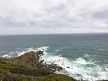
Cape Liptrap sits high above the Bass Strait with steep slopes and cliffs of folded marine sediments flanked by rock pinnacles and wave cut platforms. At the end of the peninsula is Cape Liptrap Lighthouse that was built in 1951 in cast concrete, and is octagonal in shape.
Surrounding Townships
To the east of Cape Liptrap are the townships of Walkerville , Sandy Point and Waratah Bay.
To the northwest is Venus Bay, the Tarwin River and the townships of Tarwin Lower, Inverloch and Wonthaggi.
Geography
Waratah Bay is located approximately 200km south east of Melbourne, Latitude 38° 54' 5" S, Longitude 145° 55' 4" E
References
- Grant, James (1803). The narrative of a voyage of discovery, performed in His Majesty's vessel the Lady Nelson, of sixty tons burthen: with sliding keels, in the years 1800, 1801, and 1802, to New South Wales. Printed by C. Roworth for T. Egerton. pp. 71–72. ISBN 978-0-7243-0036-5. Retrieved 25 January 2012.