Carajás Mountains
The Carajás Mountains or Serra dos Carajás are a mountain range to the west of the municipality of Marabá in the Pará state of Brazil. Monte Redenção, Marabá's highest point, is located there.
| Carajás Mountains | |
|---|---|
 | |
| Highest point | |
| Peak | Monte Redenção |
| Elevation | 716 m (2,349 ft) |
| Coordinates | 6°16′37″S 50°34′54″W |
| Naming | |
| Native name | Serra dos Carajás |
| Geography | |
| Country | Brazil |
| Region | North |
| Borders on | Carajás Mountains |
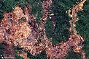
The mountains are contained in the Carajás National Forest, a 411,949 hectares (1,017,950 acres) sustainable use conservation unit created in 1998 that includes mining operations in a huge deposit of high-grade iron ore.[1]
See also
References
- FLONA de Carajás (in Portuguese), ISA: Instituto Socioambiental, retrieved 2016-05-30
Further reading
- Newton Pereira de Rezende, Carajás: memórias da descoberta, Editora Gráfica Stamppa, 2009, 316 pg. Book in Portuguese telling the history of Carajás' iron mines' discovery.
This article is issued from Wikipedia. The text is licensed under Creative Commons - Attribution - Sharealike. Additional terms may apply for the media files.