Carlow/Mayo
Carlow/Mayo is a township in northern Hastings County in Eastern Ontario, Canada. It was formed in 2001 by the amalgamation of the townships of Carlow and Mayo.
Carlow/Mayo | |
|---|---|
| Township of Carlow/Mayo | |
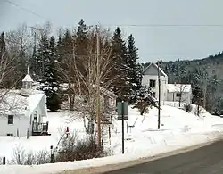 Community of McArthur Mills along Hwy 28. | |
 Carlow/Mayo | |
| Coordinates: 45°08′N 77°37′W | |
| Country | |
| Province | |
| County | Hastings |
| Settled | 1850s |
| Incorporated | January 1, 2001 |
| Government | |
| • Type | Township |
| • Reeve | Bonnie Adams |
| • Federal riding | Prince Edward—Hastings |
| • Prov. riding | Prince Edward—Hastings |
| Area | |
| • Land | 390.79 km2 (150.88 sq mi) |
| Population (2016)[2] | |
| • Total | 864 |
| • Density | 2.2/km2 (6/sq mi) |
| Time zone | UTC-5 (EST) |
| • Summer (DST) | UTC-4 (EDT) |
| Postal Code | K0L 1G0 |
| Area code(s) | 613 (332 exchange) |
| Website | www |
Historically, the economy in the area was based on timber and mining. The Little Mississippi River and York River were used to transport logs out of the forests. Now, tourism is an important part of the local economy. Over half of the land in the region is designated crown land.
Carlow and Mayo were named after the counties of the same name in Ireland (County Carlow and County Mayo).
Communities within the municipal boundaries include: Bessemer, Boulter, Childs Mines, Craigmont, Fort Stewart, Hartsmere, Havergal, Hermon, McArthur Mills, New Carlow, and Rowland.
Demographics
| Canada census – Carlow/Mayo community profile | |||
|---|---|---|---|
| 2016 | 2011 | 2006 | |
| Population: | 864 (-3.1% from 2011) | 892 (-6.1% from 2006) | 950 (+14.0% from 2001) |
| Land area: | 390.79 km2 (150.88 sq mi) | 390.94 km2 (150.94 sq mi) | 388.36 km2 (149.95 sq mi) |
| Population density: | 2.2/km2 (5.7/sq mi) | 2.3/km2 (6.0/sq mi) | 2.4/km2 (6.2/sq mi) |
| Median age: | 54.1 (M: 54.9, F: 52.8) | 45.9 (M: 45.9, F: 45.9) | |
| Total private dwellings: | 627 | 585 | 665 |
| Median household income: | $54,208 | $43,460 | |
| References: 2016[3] 2011[4] 2006[5] earlier[6] | |||
Mother tongue:[5]
- English as first language: 94.7%
- French as first language: 3.7%
- English and French as first language: 0%
- Other as first language: 1.6%
| Year | Pop. | ±% |
|---|---|---|
| 1996 | 891 | — |
| 2001 | 833 | −6.5% |
| 2006 | 950 | +14.0% |
| 2011 | 892 | −6.1% |
| 2016 | 864 | −3.1% |
| [7][1][2] | ||
Prior to amalgamation (2001):
- Total Population in 1996: 891
- Carlow (township): 430
- Mayo (township): 461
- Population in 1991:
- Carlow (township): 424
- Mayo (township): 446
See also
References
- "Carlow/Mayo census profile". 2011 Census of Population. Statistics Canada. Retrieved 2012-02-29.
- "Census Profile, 2016 Census: Carlow/Mayo, Township". Statistics Canada. Retrieved June 16, 2019.
- "2016 Community Profiles". 2016 Canadian Census. Statistics Canada. February 21, 2017. Retrieved 2018-02-19.
- "2011 Community Profiles". 2011 Canadian Census. Statistics Canada. July 5, 2013. Retrieved 2012-02-29.
- "2006 Community Profiles". 2006 Canadian Census. Statistics Canada. March 30, 2011. Retrieved 2012-02-29.
- "2001 Community Profiles". 2001 Canadian Census. Statistics Canada. February 17, 2012.
- Statistics Canada: 1996, 2001, 2006 census
External links
Places adjacent to Carlow/Mayo | |
|---|---|
| Cities | 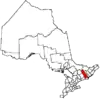 | |
|---|---|---|
| Towns | ||
| Townships | ||
| First Nations | ||
| Indian reserves | ||
| ||