Carretera Austral
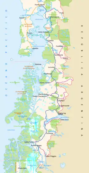
The Carretera Austral (CH-7, in English: Southern Way) is the name given to Chile's Route 7. The highway runs south for about 1,240 kilometers (770 mi) from Puerto Montt to Villa O'Higgins, passing through rural Patagonia.[1]
| |
|---|---|
| Ruta 7 | |
 | |
| Highway system | |
| Highways in Chile |
.svg.png.webp)
.svg.png.webp)

Carretera Austral provides road access to Chile's Aysén Region and southern parts of Los Lagos Region. These areas are sparsely populated and despite its length, Carretera Austral provides access to only about 100,000 people. The largest city along the entire road is Coyhaique with a population of 44,850 in 2002.[2]
History
Construction of the highway was commenced in 1976 under the dictatorship[3] of Augusto Pinochet in order to connect a number of remote communities. Before that, in the 1950s and 1970s, there had been unsuccessful attempts to build access roads in the region.[4] It is among the most ambitious infrastructure projects developed in Chile during the 20th century.
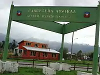
Since the military dictatorship the Carretera Austral bears the name of Augusto Pinochet.
Carretera Austral has a strategic meaning due to the difficult access by land to a significant portion of Chile's southern territory. This area is characterized by thick forests, fjords, glaciers, canals and steep mountains. Access by sea and air is also a complex task due to extreme winter weather conditions. For decades, most of the land transportation had to cross the border to Argentina in order to reach again Chile's Patagonia. These difficulties were deepened during the 1970s due to the Beagle Conflict crisis. In order to strengthen the Chilean presence in these isolated territories and ensure the land connection to the rest of the country, the government planned the construction of this road, which was executed by the Chilean Army's Engineering Command. More than 10,000 soldiers worked on its construction.
The highway opened to traffic in 1988, and by 1996 was completed to Puerto Yungay. The last 100 kilometers (62 mi) to Villa O'Higgins were opened in 2000. In 2003, a branch road to Caleta Tortel was finished.[5]
Places along the highway
- Puerto Montt
- Reloncaví Sound
- Hornopirén National Park
- Yelcho Lake
- Pumalín Park
- Chaitén
- Queulat National Park
- Coyhaique
- Balmaceda
- Río Ibáñez
- Cerro Castillo
- General Carrera Lake
- Cochrane
- Baker River
- Confluence of the Baker River and the Nef River
- Patagonia Park
- Caleta Tortel
- Villa O'Higgins
Ferry crossings
Traveling the entire route requires the use of three ferry services, :
- A 40-minute crossing about 45 kilometers (28 mi) south of the start of the highway in Puerto Montt, between Fishing Creeks "La Arena" and "Puelche". This ferry service runs 24/7 with departures every 30 minutes approx. in the day (at night the activity decreases). During the summer (Dec–Feb) the number of departures is increased with boardings every 15, 30 and 45 minutes; the boarding is in order of arrival for passengers, vehicles, motorcycles and bikes. Tickets are available at the waiting line, where personal will approach the vehicle. Check prices and schedules on the ferry's website: www.transportesdelestuario.cl. Passengers without vehicle can board for free during the entire year. Onboard there are restrooms, coffee shops and passengers may walk around the ferry to enjoy the view during the ride.
- a 5-hour crossing from Hornopiren (110 kilometers (68 miles) south of Puerto Montt) to Caleta Gonzalo, which requires passengers to purchase tickets prior to boarding. This can be done online at the site www.taustral.cl where you can also check prices and schedules. On board the ferries there are large passengers' rooms, with coffee shops and restrooms. Passengers can also enjoy the view in the ferry's deck during the ride.
- a 50-minute crossing from Puerto Yungay to Rio Bravo, connecting to the final 100 kilometers (62 mi) of the highway.
Current activity
| Patagonia |
|---|
 |
| Regions |
|
Eastern Patagonia Western Patagonia Tierra del Fuego |
| Ecoregions |
|
Valdivian forests Magellanic forests Magellanic moorland Patagonian steppe |
| National parks |
|
Laguna San Rafael · Los Glaciares Nahuel Huapi · Torres del Paine Alberto de Agostini · Tierra del Fuego |
| Administrative division |
|
Chile Palena Province Aysén Region Magallanes Region Argentina Neuquén Province · Río Negro Province Chubut Province · Santa Cruz Province Tierra del Fuego Province |
The highway began as almost entirely unpaved, but more sections are becoming paved each year. As of March 2018, the paved road ends at Villa Cerro Castillo, with roadworks going on just south of there.
There is also a plan to extend the road to Magallanes Region, which still lacks domestic road connection to the rest of Chile. This means constructing a 935-kilometre (581 mi) branch Rio Bravo-Ventisquero Montt-Puerto Natales, with 9 ferry crossings planned.[6] By January 2007, the construction on the Rio Bravo-Ventisquero Montt section had begun, with the branch off point from the main Rio Bravo-Villa O'Higgins road being at 48.00°S 73.13°W.
Gallery
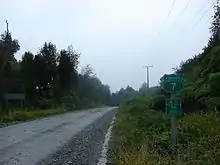
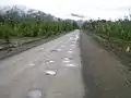 Carretera Austral near Caleta Gonzalo
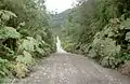 Carretera Austral near Caleta Gonzalo
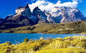
 Villa O'Higgins, the end of Carretera Austral
References
- "Carretera Austral - Presentacion; in Dirección de Vialidad" (in Spanish). Ministerio de Obras Públicas, Dirección de Vialidad. Archived from the original on 2008-05-21.
- "Census 2002" (in Spanish).
- http://www.emol.com/noticias/nacional/2013/10/03/622683/textos-escolares-deberan-calificar-el-periodo-de-augusto-pinochet-como-dictadura-militar.html
- "History of the Carretera Austral". TurismoChile.com. Archived from the original on 2008-09-19. Retrieved 2008-08-24.
- "Carretera Austral". Aisen Bridges Travel. Archived from the original on 2008-12-23.
- "Carretera Austral - Nuevos trazados; in Dirección de Vialidad" (in Spanish). Ministerio de Obras Públicas, Dirección de Vialidad. Archived from the original on 2008-07-07.
External links
| Wikimedia Commons has media related to Carretera Austral. |
| Wikivoyage has a travel guide for Carretera Austral. |