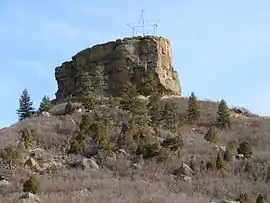
Castle Rock (Colorado)
Castle Rock is a butte in the Colorado Piedmont region of the Great Plains.[1][2] An area landmark, it is the namesake of the town of Castle Rock, Colorado.[3]
| Castle Rock | |
|---|---|
 | |
| Highest point | |
| Elevation | 6,590 ft (2,010 m) |
| Prominence | 370 ft (110 m) |
| Coordinates | 39°22′44.72″N 104°51′21.79″W |
| Geography | |
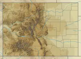 Castle Rock Location in Colorado | |
| Location | Castle Rock, Colorado, United States |
The butte's caprock consists of rhyolite, rock which is strongly resistant to erosion. About 58 million years ago, a volcanic eruption took place that covered the area around Castle Rock with 20 feet (6.1 m) of rhyolite. After a few million years, mass flooding and erosion of the volcanic rock gave way to the castle-shaped butte visible today.[4]
Public hiking trails on the butte are in Rock Park, at the intersection of Front Street and Canyon Drive in the city of Castle Rock. The trailhead and parking are about two blocks south of the intersection on Front Street, for a 1.4-mile roundtrip hike to the summit of the town's namesake. Other trailheads can be found along Canyon Drive and Sunset Drive.[5]
References
- "Colorado Geology Overview". Colorado Geology Photojournals - A Tribute to Colorado's Physical Past and Present. Retrieved 2013-10-01.
- "Physiographic Provinces of Colorado". Colorado Geological Survey. Archived from the original on 2012-05-24. Retrieved 2013-10-01.
- Dawson, John Frank (1954). Place names in Colorado: why 700 communities were so named, 150 of Spanish or Indian origin. Denver, CO: The J. Frank Dawson Publishing Co. p. 13.
- Johnson, Kirk R.; et al. (2006). Ancient Denvers. Fulcrum Publishing. ISBN 978-1-55591-554-4.
- Day Hikes Near Denver: Castle Rock Trail, 8 Mar 2018.