Chöpfenberg
The Chöpfenberg (1,896 m) is a mountain of the Schwyzer Alps, located on the border between the Swiss cantons of Schwyz and Glarus. It lies on the range north of the Mutteristock, between the valleys of the Wägitalersee and the Linth.
| Chöpfenberg | |
|---|---|
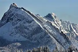 View from the west side | |
| Highest point | |
| Elevation | 1,896 m (6,220 ft) |
| Prominence | 465 m (1,526 ft) [1] |
| Isolation | 1.48 km (0.92 mi) |
| Coordinates | 47°7′7″N 8°58′7″E |
| Geography | |
 Chöpfenberg Location in Switzerland | |
| Location | Schwyz/Glarus, Switzerland |
| Parent range | Schwyzer Alps |
References
- Retrieved from the Swisstopo topographic maps. The key col is the Scheidegg (1,431 m).
This article is issued from Wikipedia. The text is licensed under Creative Commons - Attribution - Sharealike. Additional terms may apply for the media files.