Charleston Harbor
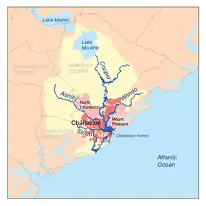
The Charleston Harbor is an inlet (8 sq mi/20.7 km²) of the Atlantic Ocean at Charleston, South Carolina. The inlet is formed by the junction of Ashley and Cooper rivers at 32°49′7.10″N 79°55′40.41″W. Morris and Sullivan's Islands shelter the entrance. Charleston Harbor forms part of the Intracoastal Waterway.[1]
Like most river mouths in the Southeast of the United States, the inlet is part of a drowned coastline, defined by a rise in sea level in recent geologic time.
History

The harbor is home to Fort Sumter, site of the first shots of the American Civil War. Charleston Harbor was also the site of the first successful submarine attack in history on February 17, 1864, when the H.L. Hunley made a daring night attack on the USS Housatonic, during the American Civil War.[2]

The 12-foot natural depth of the harbor was a major reason for the establishment and growth of Charleston. The Rivers and Harbors Act of 1852 authorized the federal government to dredge the channels of the harbor to a depth of 17 feet. This deepening work was interrupted by the Civil War and was not completed until after the war's end.[3] The jetties at the entrance to the harbor were constructed between 1878 and 1886.[4]
Transportation
The harbor includes public terminals owned and operated by the South Carolina Ports Authority, as well as private terminals. Existing federal channels are dredged to an authorized depth of 45 feet below mean lower low water. This depth is too shallow for Post-Panamax ships. The largest ships must carry less cargo, wait for favorable tide conditions, or combine these two approaches to reach port in Charleston. As of 2015, the U.S. Army Corps of Engineers began to design a deepening of the channels to 52 feet.[5][6] The harbor deepening project was spurred on by the Panama Canal’s recent expansion in an effort to handle the larger ships traveling from Panama without facing restrictions listed above.[7] As of May 2017, the project will cost around $500 million, with $317.5 million federally allocated.[8][9] Port officials plan to make the Charleston Harbor the deepest harbor on the East Coast by the end of the decade.[10] [11]
See also
- Charleston, South Carolina in the American Civil War
- Waterways forming and crossings of the Atlantic Intracoastal Waterway
References
- Charleston Harbor. Columbia University Press at Bartleby.com. Accessed 2 November 2006.
- U.S. Navy history website Archived October 14, 2007, at the Wayback Machine
- U.S. Army Corps of Engineers, Charleston Harbor Post 45: Final Integrated Feasibility Report and Environmental Impact Statement, Page 1-6.
- Sargent, Francis E. Case Histories of Corps Breakwater and Jetty Structures, Department of the Army, Vicksburg Mississippi. September 1988. Page 34. Accessed September 25, 2015.
- Landers, Jay (September 2015). "Corps to Begin Design Phase of Charleston Harbor Deepening Project". Civil Engineering. Reston, Virginia: American Society of Civil Engineers. 85 (9): 24–26.
- "Charleston Harbor deepening project allocated $17.5M in federal funding". Retrieved 2017-09-14.
- "Charleston Harbor deepening project allocated $17.5M in federal funding". Retrieved 2017-09-14.
- "Charleston Harbor deepening project allocated $17.5M in federal funding". Retrieved 2017-09-14.
- "www.scspa.com/news/charleston-harbor-deepening-project-receives-construction-funding/". www.scspa.com. Retrieved 2017-09-14.
- "Charleston Harbor deepening project allocated $17.5M in federal funding". Retrieved 2017-09-14.
- http://www.postandcourier.com/business/charleston-port-on-its-way-to-east-coast-s-deepest/article_51a3f3be-40d4-11e7-982b-ff4f04ac8d2e.html
External links
- Charleston Harbor Post 45, Official project website
- South Carolina State Ports Authority