Chathenkary
Chathenkary is a village in Upper Kuttanadu division Pathanamthitta district in the state of Kerala, India.[1]
Chathenkary | |
|---|---|
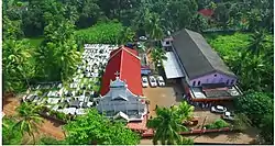 Chathenkary St paul's Mtc Aerial view | |
 Chathenkary Location in Kerala, India | |
| Coordinates: 9°22′0″N 76°32′0″E | |
| Country | |
| State | Kerala |
| District | Pathanamthitta |
| Highest elevation | 1.5 m (4.9 ft) |
| Lowest elevation | −1 m (−3 ft) |
| Population (2001) | |
| • Total | 15,089 |
| Languages | |
| • Official | Malayalam, English |
| Time zone | UTC+5:30 (IST) |
| PIN | 689112 |
| Vehicle registration | KL-27 |
| Nearest city | Thiruvalla |
| Lok Sabha constituency | Pathanamthitta |
| Vidhan Sabha constituency | Thiruvalla |
Chathenkari is a small village / hamlet in Kuttanadu. It comes under the Upper Kuttanadu division. It is situated in Thiruvalla Taluk in Pathanamthitta District of Kerala state, India. It comes under Peringara Panchayath. It belongs to South Kerala Division. It is located 36 km towards west from District headquarters Pathanamthitta, 6 km from Thiruvalla and 128 km from State capital Thiruvananthapuram.
Worship centres
- St Paul's Mar Thoma Church[2]
- Chathenkary Sri Bhagavathi Temple
- St. Mathew's marthoma church
- St Joseph Chapel Chathenkary
- St. Mary's Malankara Catholic Church
- Sharon Fellowship church
- Chathenkary Sree Ardhanareeshwara Temple
Schools
- Govt LP School
- Govt New LP School
- SNDP High School, Chathenkary
Politics
The Indian National Congress, the CPIM, the JD(S) and the Kerala Congress(M) are the major political parties in this area.
Hospitals
- Manak Hospital, Chathenkary mukku
- Primary Health Centre, Chathenkary
Notable Person's
- Late.Adv.Mammen Mathai M.L.A
- Rajesh Chathenkary
- Satheesh chathenkary
Nearby places
- Mepral
- Muttar
- Neerattupuram
- Peringara
- Nedumpuram
- Podiyadi
- Kavumbhagam
- Amichakery
Transport
Bus
Private and KSRTC bus available from Chathenkary junction to other parts of Kerala.
Railway
Thiruvalla railway station is nearby station to Chathenkary.
Air
Cochin International Airport Nedumbassery is 115 km away from Chathenkary.