Chilcotin River
The Chilcotin River /tʃɪlˈkoʊtɪn/[5] is a 241-kilometre (150 mi) long tributary of the Fraser River in southern British Columbia, Canada. It drains the Chilcotin Plateau, which lies between the Fraser River and the Coast Mountains. It starts northeast of Itcha Mountain and flows generally southeast to join the Fraser about 22 km upstream from Gang Ranch.[6]
| Chilcotin River | |
|---|---|
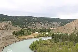
 Chilcotin in Farwell Canyon | |
| Location | |
| Country | Canada |
| Province | British Columbia |
| Physical characteristics | |
| Source | Itcha Lake |
| • location | Northeast of Itcha Mountain |
| • coordinates | 52°47′09″N 124°45′51″W |
| • elevation | 5,223 ft (1,592 m)[1] |
| Mouth | Fraser River |
• location | Upstream from Gang Ranch |
• coordinates | 51°44′22″N 122°24′03″W |
• elevation | 1,152 ft (351 m)[2] |
| Length | 241 km (150 mi) |
| Basin size | 19,300 km2 (7,500 sq mi)[3] |
| Discharge | |
| • location | below Big Creek[4] |
| • average | 102 m3/s (3,600 cu ft/s)[4] |
| • minimum | 13.8 m3/s (490 cu ft/s) |
| • maximum | 1,100 m3/s (39,000 cu ft/s) |
Course

The Chilcotin originates at the outlet of remote Itcha Lake,[7] in Itcha Ilgachuz Provincial Park. Between the outlet of Itcha Lake and its confluence with its primary tributary, the Chilko River, it is about 72 km in length, most of which the river is flowing generally southeast. Several portions of the upper and middle reaches, in particular the 12 km or so stretch starting from Itcha Lake, are very swamp-like and slow moving. Chicotin Falls,[8] a small cascade located about 23 km below its source at the head of a small canyon, is one of the few swift spots on the Chilcotin above its confluence with the Chilko. Chilcotin Lake, a small, irregularly shaped swamp-like lake, is located about 44 km upstream from the Chilko.
The Chilko/Chilcotin confluence is unique in the sense that the Chilko is actually several times larger in volume than the Chilcotin, yet the Chilko still "joins" the Chilcotin.
Below the confluence, the Chilcotin is quite large and silty. It flows through three large canyons, Bull Canyon, Big Creek Canyon and Farwell Canyon. It is about 83 km from the Chilko confluence to the Chilcotin's mouth. Farwell Canyon is located about 15 km above the Fraser.
Major tributaries
- Moore Creek – Joins the Chilcotin about 10 km below Chilcotin Falls.
- Punkutlaenkut Creek – Feeds the river about 7 km below Moore Creek.
- Clusko River – Hits the Chilcotin about 8 km above Chilcotin Lake.
- Palmer Creek – Joins the river via the west end of Chilcotin Lake.
- Chilanko River – Feeds the river about 15.5 km above the Chilko.
- Chilko River – The Chilcotin's largest tributary by far, the Chilko joins the Chilcotin about 5 km above Bull Canyon.
- Big Creek – Joins the Chilcotin in Big Creek Canyon.
References
- Source elevation derived from Google Earth.
- Mouth elevation derived from Google Earth.
- Benke, Arthur C.; Cushing, Colbert E. (2009). Field Guide to Rivers of North America. Academic Press. pp. 314–315. ISBN 978-0-12-378577-0. Retrieved 5 August 2013.
- "Archived Hydrometric Data Search". Water Survey of Canada. Archived from the original on 24 December 2010. Retrieved 17 August 2013. Search for Station 08MB005 Chilcotin River below Big Creek
- "Pronunciation Guide". A Guide to Aboriginal Organizations and Services in British Columbia 2011 / 2012 (PDF). p. VII. Archived from the original (PDF) on 2013-09-27. Retrieved 17 November 2013.
- "Chilcotin River". BC Geographical Names.
- "Itcha Lake". BC Geographical Names.
- Waterfalls of the Pacific Northwest: Chilcotin Falls