Chimanimani National Reserve
Chimanimani National Reserve (Portuguese: Reserva Nacional de Chimanimani) is a protected area in Manica Province of Mozambique. It is located in the Chimanimani Mountains on the border with Zimbabwe, and together with Zimbabwe's Chimanimani National Park it forms the Chimanimani Transfrontier Park.[1]
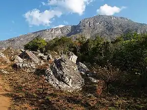
The reserve was proclaimed in 2003, and has an area of 634 km2. The reserve includes the Mozambican portion of the Chimanimani Mountains, including Monte Binga (2436 m), Mozambique's highest peak. The reserve has a larger buffer zone (1723 km2),[2] which extends into lower-elevation areas to the south, east, and north, and includes the Moribane, Mpunga, Maronga, and Zomba forest reserves. The forest Moribane, Mpunga, and Maronga reserves were established in 1953.[3]
The locals preserve the cave paintings, ancient traditions and beliefs, all of which give the park a cultural identity. The Reserve can be reached across the border from Machipanda, the city of Beira (Beira Corridor) from the city of Chimoio. The reserve has several road connections with the north, center and south of Mozambique, as well as with Zimbabwe.[4]
References
- Briggs, Philip (2014). Mozambique. Bradt Travel Guides. pp. 221–222. ISBN 1841624969.
- Hudson, A., Milliken, W., Timberlake, J. et al. Natural Plant Resources for Sustainable Development: Insights from Community Use in the Chimanimani Trans-Frontier Conservation Area, Mozambique. Hum Ecol 48, 55–67 (2020).
- Ghiurghi, Andrea & Dondeyne, S. & Bannerman, J.. (2010). Chimanimani national reserve: management plan. 10.13140/2.1.1734.6240.
- "Chimanimani – ANAC". www.anac.gov.mz. Retrieved 2020-09-28.
External links
![]() Media related to Chimanimani National Reserve at Wikimedia Commons
Media related to Chimanimani National Reserve at Wikimedia Commons