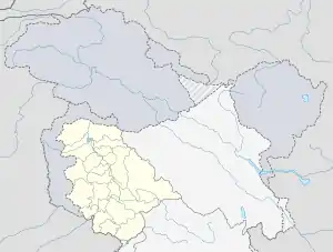
Chinta Valley
Chinta Valley is a valley[2] and a village located 20 kilometres (12 mi) northeast of Bhaderwah town on Bhaderwah-Jai road. It is covered with thick coniferous forests from all sides with a stream flowing through it known as Chinta Nallah.[lower-alpha 1][3] A village called Thuba divides the valley from Bhaderwah.[4]
| Chinta Valley | |
|---|---|
 Chinta Valley in Bhaderwah, Jammu and Kashmir | |
 Chinta Valley Chinta Valley in Bhaderwah, Jammu and Kashmir  Chinta Valley Chinta Valley (India) | |
| Floor elevation | 6,500 ft (2,000 m)[1] |
| Naming | |
| Native name | चिन्ता घाटी |
| English translation | Chinta Valley |
| Geography | |
| Country | India |
| State | Jammu and Kashmir |
| Region | Jammu region |
| District | Doda district |
| Coordinates | 33.017365°N 75.727157°E |
About
Chinta is situated at the elevation of 6,500 ft above sea level in Bhaderwah tehsil (subdistrict) of Doda district. Famous Subarnag peak having Subarnag temple[lower-alpha 2] (10,200 ft above sea level) is only six Kilometers far through bridle path near the Bhaderwah-Chinta road.[3] Bhaderwah Festival is celebrated every year starts from Raksha Bandan and ends on the full moon day of November in Chinta and other villages of Bhaderwah.[6] A Govt Primary Health Center (PHC) is also located in Chinta.[7]
Tourism
Chinta is one of the tourist destinations in Bhaderwah, Jammu and Kashmir. Chinta and Jai valleys have the favourable climate and environment for basics and training in paragliding. Paragliding is the special attraction of hilly areas but it is feasible all over the year except wet seasons.[8] Six kilometres before Chinta Valley, on the Chinta-Bhaderwah road, a footpath leads towards the Subarnag peak, where everyone can get a sweeping view of the Chinta valley and the entire town of Bhaderwah.[3]
Road connectivity
There are three roads which connects Jai Valley to other parts, which are as follows;
Main road
- Bhaderwah-Chinta-Jai Road, a 32 kilometres (20 mi) road from Bhaderwah town to Jai Valley passing through Chinta at a distance of 20 kilometres (12 mi), having blacktop except some areas, is the main road which is commonly used to visit Chinta.[9]
Alternate roads
There are two under construction alternate roads which are actually meant for Jai Valley known as Gandoh-Jai Road and Kahara-Jai Road but they can be used for Chinta also because Chinta is at a distance of 10 Kilometers south from Jai.[10]
Famous food
Bhaderwahi Rajmash[lower-alpha 3] are very famous in Jammu region. These rajmash are grown as intercrop with maizes in Chinta Valley of Doda district.[11]
Notes
- Nallah is local word which refers to water stream or rivulet.
- Subar Nag Temple, an ancient temple dedicated to Subar Nag or Seshnag; a serpentine divinity in the Hindu religion, is located in the Doda district.[5]
- Rajmash is the local name of Rajma (the red Kidney bean).
References
| Look up chinta valley in Wiktionary, the free dictionary. |
- Qazi, S.A. (2005), Systematic Geography of Jammu and Kashmir, APH Publishing Corporation, p. 245, ISBN 81-7648-786-4
- Chowdhary, Charu (20 Jun 2019). "Bhaderwah: What to Experience in J&K's Mini Kashmir". India.com. Retrieved 28 Jun 2020.
- "Chinta Valley". www.jktourism.org. Jammu and Kashmir Tourism. Retrieved 28 Jun 2020.
- "Chinta Valley, Bhaderwah". www.nativeplanet.com. Retrieved 28 Jun 2020.
- "15,000 devotees visit ancient Subar Nag temple on Baisakhi eve". The Times of India. 13 Apr 2017. Retrieved 29 Jun 2020.
- Census Handbook Doda (Census 2011) (PDF). Doda district: Govt of India. 2011. p. 119.
- "23 doctors transferred". 19 Jan 2020. Retrieved 30 Jun 2020.
- "Paragliding at Khanni Top". www.jktourism.org. Jammu and Kashmir Tourism. Retrieved 29 Jun 2020.
- "Jai Valley, an eco-health resort in Bhaderwah". JK Report. Retrieved 24 Jun 2020.
- Sharma, Gopal (15 Jun 2020). "Gandoh-Jai-Bhaderwah Road incomplete even after 17 yrs, project jumps several deadlines". Daily Excelsior. Retrieved 23 Jun 2020.
- "Bhaderwah Rajmash: A variety unique in taste". Daily Excelsior. 7 Jul 2019. Retrieved 30 Jun 2020.