Clerkenwell Road
It runs west–east from Gray's Inn Road in the west, to Goswell Road in the east. Its continuation at either end is Theobald's Road and Old Street respectively.
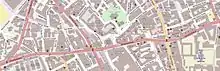
The immediate vicinity of Clerkenwell Road
_-_geograph.org.uk_-_415612.jpg.webp)
Clerkenwell Road, at the St John Street crossroads
Clerkenwell Road is a street in London.
Clerkenwell Road and Theobalds Road were constructed by the Metropolitan Board of Works in 1874–78 as the central portion of an intended cross-capital arterial road, linking the West End and East End.[1]
The road is served by London Bus routes 55, 243 and night route N55.
References
- "CHAPTER XIV. Clerkenwell Road". British History. Retrieved 9 July 2014.
This article is issued from Wikipedia. The text is licensed under Creative Commons - Attribution - Sharealike. Additional terms may apply for the media files.