Cleveland Circle station
Cleveland Circle is a surface light rail station on the MBTA Green Line C branch, located in the Brighton neighborhood of Boston, at Cleveland Circle. Cleveland Circle station is handicapped accessible, with raised platforms to accommodate low-floor trams.
Cleveland Circle | |||||||||||
|---|---|---|---|---|---|---|---|---|---|---|---|
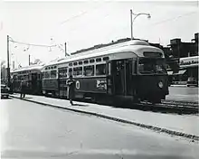
%252C_May_2016.JPG.webp) An inbound train at Cleveland Circle in 2016 | |||||||||||
| Location | Beacon Street at Chestnut Hill Avenue Brighton, Massachusetts | ||||||||||
| Coordinates | 42°20′10.38″N 71°8′56.42″W | ||||||||||
| Owned by | Massachusetts Bay Transportation Authority | ||||||||||
| Platforms | 2 side platforms | ||||||||||
| Tracks | 2 | ||||||||||
| Connections | |||||||||||
| Construction | |||||||||||
| Disabled access | Yes | ||||||||||
| History | |||||||||||
| Opened | 1889 | ||||||||||
| Passengers | |||||||||||
| 2011 | 1,457 (daily average)[1] | ||||||||||
| Services | |||||||||||
| |||||||||||
History
The Beacon Street line opened in 1889; most streetcars ran through Cleveland Circle to Lake Street after 1896, with some terminating at the Chestnut Hill Carhouse (renamed Reservoir Carhouse around 1900).
In 1915, the route was cut back to Reservoir, at the Reservoir Carhouse. Around 1947, the terminus was redesignated Cleveland Circle after the adjacent traffic circle, to differentiate it from the nearby commuter rail station – which, twelve years later, would become a streetcar station itself. Although Cleveland Circle is no longer a traffic circle, the station retains its name.
In the early 2000s, the MBTA modified key surface stops with raised platforms for accessibility. Portable lifts were installed at Cleveland Circle around 2000 as a temporary measure.[2][3] The platform modifications - part of a $32 million modification of thirteen B, C, and E branch stations - were completed around 2003.[4][5] On May 2, 2007, the MBTA added a wooden mini-high platform on the outbound side, allowing level deboarding from older Type 7 LRVs. These platforms were installed at eight Green Line stations in 2006–07 as part of the settlement of Joanne Daniels-Finegold, et al. v. MBTA.[6][7] The ramp was removed in July 2020 during a track reconstruction project.[8]
References
- "Ridership and Service Statistics" (PDF) (14th ed.). Massachusetts Bay Transportation Authority. 2014.
- "Executive Summary" (PDF). Program of Mass Transportation. Boston Regional Metropolitan Planning Organization. January 2004. p. 2-9. Archived from the original (PDF) on February 20, 2012.
- "Subway Map" (PDF). Massachusetts Bay Transportation Authority. 2001. Archived from the original (PDF) on July 1, 2001.
- "Subway Service". Ridership and Service Statistics. Massachusetts Bay Transportation Authority. October 2003. p. 2.19 – via Internet Archive.
- "Planned Accessibility Projects - On Board the Green Line". Massachusetts Bay Transportation Authority. Archived from the original on August 10, 2004.
- "Settlement Agreement" (PDF). Joanne Daniels-Finegold et al. v. MBTA. April 10, 2006. pp. 10–11.
- "Green Line Stations Upgraded to Improve Accessibility" (PDF). TRANSReport. Boston Regional Metropolitan Planning Organization. June 2007. Archived from the original (PDF) on January 16, 2011.
- "Building a Better T: Green Line C Branch Track Improvements and Intersection Upgrades Accelerated, Kenmore – Cleveland Circle Work Begins Evening of July 5" (Press release). Massachusetts Bay Transportation Authority. June 24, 2020.
External links
![]() Media related to Cleveland Circle station at Wikimedia Commons
Media related to Cleveland Circle station at Wikimedia Commons