Clogh, County Wexford
Clogh (Irish: An Chloch)[1] is a small rural village in Ireland. Many local residents refer to the village as "Clough", and this is regarded as the proper spelling.
Clogh
An Chloch | |
|---|---|
Village | |
.jpg.webp) Until bypassed in 2007, the village was on the N11 road | |
 Clogh Location in Ireland | |
| Coordinates: 52°38′N 6°20′W | |
| Country | Ireland |
| Province | Leinster |
| County | County Wexford |
| Time zone | UTC+0 (WET) |
| • Summer (DST) | UTC-1 (IST (WEST)) |
| Irish Grid Reference | T121558 |
It is situated on the R772 regional road in County Wexford 5 km (3.1 mi) southwest of Gorey. Until it was bypassed in July 2007 the village was situated on the N11 national primary route from Wexford Town to Dublin.
There is a memorial to the Battle of Tubberneering in the village.[2] St. Luke's church (Church of Ireland), just north of the village, was built in 1831.[3]
References
- "An Chloch / Clogh". logainm.ie. Placenames Database of Ireland. Retrieved 19 January 2021.
- "Clogh, Clogh latterly Clough, Wexford". buildingsofireland.ie. National Inventory of Architectural Heritage. Retrieved 19 January 2021.
- "Saint Luke's Church (Liskinfere), Clogh latterly Clough, Wexford". buildingsofireland.ie. National Inventory of Architectural Heritage. Retrieved 19 January 2021.
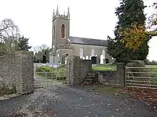
St. Luke's church (Church of Ireland) is just north of the village
This article is issued from Wikipedia. The text is licensed under Creative Commons - Attribution - Sharealike. Additional terms may apply for the media files.