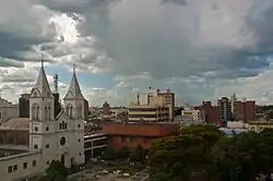
Concordia, Entre Ríos
San Antonio de Padua de la Concordia (usually shortened to Concordia) is a city in the north-east of the province of Entre Ríos in the Argentine Mesopotamia. It had about 149,450 inhabitants at the 2010 census [INDEC], and is the head town of the department of the same name.
Concordia | |
|---|---|
 | |
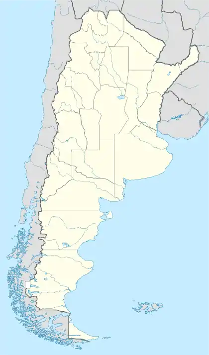 Concordia Location of Concordia in Argentina | |
| Coordinates: 31°24′S 58°2′W | |
| Country | |
| Province | |
| Department | Concordia |
| Founded | November 29, 1831 |
| Government | |
| • Mayor | Enrique Cresto (Justicialist Party) |
| Area | |
| • Total | 3.259 km2 (1.258 sq mi) |
| Elevation | 21 m (69 ft) |
| Population (2010 census) | |
| • Total | 149,450 |
| • Density | 46,000/km2 (120,000/sq mi) |
| Demonym(s) | concordiense |
| Time zone | UTC-3 (ART) |
| CPA base | E3200 |
| Dialing code | +54 345 |
| Website | Official website |
Geography
Concordia lies on the right-hand (western) shore of the Uruguay River, opposite the city of Salto in Uruguay. The two cities are joined by a road/railway link that is part of the Salto Grande Dam complex (starting on the Argentine side 18 km north from the center of Concordia).
Climate
According to the Köppen climate classification, Concordia has a humid subtropical climate (Cfa).[1]:8 Mean monthly temperatures range from 12.5 °C (54.5 °F) in July, the coldest month, to 25.3 °C (78 °F) in January, the warmest month.[1]:8 Concordia receives a mean annual precipitation of 1,372.9 mm (54 in).[1]:11 Fall (March to May) is the wettest season while winter (June to August) is the driest season.[1]:11 However, there is great year to year variability in annual precipitation.[1]:12 The frost free period is 10 months long and in an average year, there are 8.6 days with frost.[1]:9
| Climate data for Concordia, Entre Ríos (Comodoro Pierrestegui Airport) 1981–2010, extremes 1963–present) | |||||||||||||
|---|---|---|---|---|---|---|---|---|---|---|---|---|---|
| Month | Jan | Feb | Mar | Apr | May | Jun | Jul | Aug | Sep | Oct | Nov | Dec | Year |
| Record high °C (°F) | 42.1 (107.8) |
40.6 (105.1) |
38.7 (101.7) |
35.3 (95.5) |
32.5 (90.5) |
30.4 (86.7) |
32.0 (89.6) |
35.6 (96.1) |
37.2 (99.0) |
36.9 (98.4) |
38.7 (101.7) |
40.7 (105.3) |
42.1 (107.8) |
| Average high °C (°F) | 32.2 (90.0) |
30.4 (86.7) |
28.8 (83.8) |
24.5 (76.1) |
20.8 (69.4) |
17.9 (64.2) |
17.8 (64.0) |
20.2 (68.4) |
21.8 (71.2) |
25.1 (77.2) |
27.7 (81.9) |
30.6 (87.1) |
24.8 (76.6) |
| Daily mean °C (°F) | 25.8 (78.4) |
24.4 (75.9) |
22.8 (73.0) |
18.8 (65.8) |
15.3 (59.5) |
12.7 (54.9) |
12.2 (54.0) |
14.1 (57.4) |
15.7 (60.3) |
19.1 (66.4) |
21.7 (71.1) |
24.2 (75.6) |
18.9 (66.0) |
| Average low °C (°F) | 19.4 (66.9) |
18.8 (65.8) |
17.3 (63.1) |
13.8 (56.8) |
10.5 (50.9) |
8.2 (46.8) |
7.4 (45.3) |
8.6 (47.5) |
10.1 (50.2) |
13.2 (55.8) |
15.4 (59.7) |
17.7 (63.9) |
13.4 (56.1) |
| Record low °C (°F) | 8.6 (47.5) |
7.4 (45.3) |
4.9 (40.8) |
−0.3 (31.5) |
−2.7 (27.1) |
−5.0 (23.0) |
−4.8 (23.4) |
−4.2 (24.4) |
−3.0 (26.6) |
1.4 (34.5) |
3.1 (37.6) |
4.9 (40.8) |
−5.0 (23.0) |
| Average precipitation mm (inches) | 133.9 (5.27) |
145.7 (5.74) |
156.5 (6.16) |
163.4 (6.43) |
99.7 (3.93) |
82.4 (3.24) |
52.2 (2.06) |
58.7 (2.31) |
85.6 (3.37) |
136.9 (5.39) |
140.8 (5.54) |
121.0 (4.76) |
1,376.8 (54.20) |
| Average precipitation days (≥ 0.1 mm) | 8.3 | 8.4 | 8.2 | 9.0 | 7.8 | 7.8 | 6.9 | 6.4 | 7.1 | 8.8 | 7.8 | 7.8 | 94.3 |
| Average relative humidity (%) | 63.5 | 70.1 | 72.4 | 77.5 | 79.8 | 81.0 | 78.0 | 73.9 | 71.4 | 70.4 | 67.1 | 63.7 | 72.4 |
| Source: Servicio Meteorológico Nacional[2][3] | |||||||||||||
| Climate data for Concordia INTA (1967–2016) | |||||||||||||
|---|---|---|---|---|---|---|---|---|---|---|---|---|---|
| Month | Jan | Feb | Mar | Apr | May | Jun | Jul | Aug | Sep | Oct | Nov | Dec | Year |
| Record high °C (°F) | 41.4 (106.5) |
41.3 (106.3) |
40.2 (104.4) |
35.1 (95.2) |
33.2 (91.8) |
30.9 (87.6) |
31.9 (89.4) |
35.7 (96.3) |
38.3 (100.9) |
38.5 (101.3) |
39.2 (102.6) |
41.4 (106.5) |
41.4 (106.5) |
| Average high °C (°F) | 31.9 (89.4) |
30.3 (86.5) |
28.3 (82.9) |
24.5 (76.1) |
20.8 (69.4) |
17.8 (64.0) |
18.0 (64.4) |
20.0 (68.0) |
21.8 (71.2) |
24.7 (76.5) |
27.5 (81.5) |
30.5 (86.9) |
24.8 (76.6) |
| Daily mean °C (°F) | 25.3 (77.5) |
24.2 (75.6) |
22.3 (72.1) |
18.7 (65.7) |
15.5 (59.9) |
12.6 (54.7) |
12.5 (54.5) |
14.0 (57.2) |
15.7 (60.3) |
18.6 (65.5) |
21.1 (70.0) |
23.9 (75.0) |
18.7 (65.7) |
| Average low °C (°F) | 18.8 (65.8) |
18.3 (64.9) |
16.2 (61.2) |
12.9 (55.2) |
10.0 (50.0) |
7.5 (45.5) |
7.1 (44.8) |
8.0 (46.4) |
9.5 (49.1) |
12.6 (54.7) |
14.7 (58.5) |
17.2 (63.0) |
12.8 (55.0) |
| Record low °C (°F) | 8.4 (47.1) |
6.8 (44.2) |
5.5 (41.9) |
−0.4 (31.3) |
−2.9 (26.8) |
−5.1 (22.8) |
−4.8 (23.4) |
−4.2 (24.4) |
−2.4 (27.7) |
−0.4 (31.3) |
2.4 (36.3) |
6.0 (42.8) |
−5.1 (22.8) |
| Average precipitation mm (inches) | 128.0 (5.04) |
148.5 (5.85) |
140.8 (5.54) |
146.5 (5.77) |
105.2 (4.14) |
79.5 (3.13) |
61.7 (2.43) |
70.2 (2.76) |
96.7 (3.81) |
141.7 (5.58) |
135.8 (5.35) |
127.0 (5.00) |
1,372.9 (54.05) |
| Average relative humidity (%) | 67.5 | 74.1 | 76.0 | 78.8 | 82.8 | 82.9 | 81.3 | 76.9 | 73.5 | 72.9 | 69.9 | 66.0 | 75.2 |
| Mean monthly sunshine hours | 288.3 | 228.8 | 238.7 | 201.0 | 170.5 | 144.0 | 167.4 | 186.0 | 201.0 | 232.5 | 261.0 | 285.2 | 2,604.4 |
| Mean daily sunshine hours | 9.3 | 8.1 | 7.7 | 6.7 | 5.5 | 4.8 | 5.4 | 6.0 | 6.7 | 7.5 | 8.7 | 9.2 | 7.1 |
| Percent possible sunshine | 66.3 | 60.9 | 62.8 | 58.9 | 52.3 | 46.8 | 52.2 | 54.2 | 56.4 | 58.3 | 63.1 | 65.0 | 58.1 |
| Source: Instituto Nacional de Tecnología Agropecuaria[1]:9 | |||||||||||||
Nature
The city is known as the national capital of citrus production. El Palmar National Park, an important reserve for Yatay palm trees, lies 60 km south of the city.
Transport
The area is served by an airport (IATA: COC, ICAO: SAAC) located at 31°18′S 58°0′W, but which is ostensibly not operational.
Notable people

- Isidoro Blaisten (1933–2004), journalist
- Gustavo Ruiz Díaz (b. 1981), footballer
- Isaac Ganón (1916–1975), sociologist
- Celestino Piaggio (1886–1931), composer
- Isabel Sarli (1929-2019), actress and model
- Joaquin Szuchman (b. 1995), Israeli-Argentinian professional basketball player in the Israel Basketball Premier League
Gallery

References
- Ramos, Sergio; De Ruyver, Roberto; Gattinoni, Natalia; Garín, Rubén; Garran, Sergio. "Estación agrometeorológica del INTA Concordia 50 años de servicio a la comunidad" (PDF) (in Spanish). Instituto Nacional de Tecnología Agropecuaria. Retrieved 24 July 2018.
- "Estadísticas Climatológicas Normales - período 1981-2010" (in Spanish). Servicio Meteorológico Nacional. Retrieved January 21, 2018.
- "Clima en la Argentina: Guia Climática por Concordia Aero". Caracterización: Estadísticas de largo plazo (in Spanish). Servicio Meteorológico Nacional. Archived from the original on 7 February 2019. Retrieved 5 October 2017.
External links
| Wikimedia Commons has media related to Concordia. |
- Municipal information: Municipal Affairs Federal Institute (IFAM), Municipal Affairs Secretariat, Ministry of Interior, Argentina. (in Spanish)
- Municipality of Concordia – Official website
- TurismoEntreRios.com – Tourism portal of the province of Entre Ríos