Connecticut Route 540
State Road 540 (SR 540, also known as Hatchett Hill Road) is a 1.43-mile-long (2.30 km) unsigned highway in northern Connecticut which runs entirely inside the town of East Granby.
| State Road 540 | |
|---|---|
| |
| Route information | |
| Maintained by ConnDOT | |
| Length | 1.43 mi (2.30 km) |
| Existed | 1964–present |
| Major junctions | |
| West end | |
| East end | |
| Location | |
| Counties | Hartford |
| Highway system | |
| |
Route description
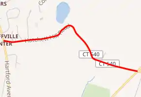
SR 540 begins at Route 189 in the western portion of the town of East Granby. It runs east, intersecting with Hamilton Road and Hatchett Hill Lane before passing the Hatchet Hill Wilderness area to the south side of the road. From the Hatchet Hill Wilderness Area, the road turns southeast for 0.3 miles (0.48 km) before turning east again. About 0.4 miles (0.64 km) from turning east, the road intersects with Route 187 and ends.[1]
History
In 1964, when the Road Reclassification Act was passed by the state, Hatchett Hill Road was given the Highway Designation of SR 440, before being changed to Route 540.
Junction list
The entire route is in East Granby, Hartford County.
| mi[2] | km | Destinations | Notes | ||
|---|---|---|---|---|---|
| 0.00 | 0.00 | ||||
| 1.43 | 2.30 | ||||
| 1.000 mi = 1.609 km; 1.000 km = 0.621 mi | |||||
References
- Google (January 4, 2020). "Connecticut Route 540" (Map). Google Maps. Google. Retrieved January 4, 2020.
- Connecticut Department of Transportation (December 31, 2014). "Highway Log" (PDF). Connecticut Department of Transportation.