Connecticut Route 668
State Road 668 (SR 668, also known as Butts Bridge Road) is a 2.00-mile-long (3.22 km) state road in eastern Connecticut that runs from Route 169 in the northwest to Route 12 in the southeast.
| State Road 668 | |
|---|---|
| |
| Route information | |
| Maintained by ConnDOT | |
| Length | 2.00 mi[1] (3.22 km) |
| Existed | 1964–present |
| Major junctions | |
| North end | |
| South end | |
| Location | |
| Counties | Windham |
| Highway system | |
| |
Route description
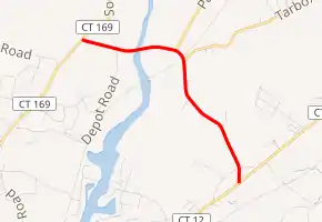
Route 668 begins at Route 169 in Canterbury. It then runs east, intersecting with Depot Road and crossing over the Quinebaug River on the Butts Bridge. From the Butts Bridge, the road intersects with Packer Road before it turns in a southeasterly direction. It then intersects with Tarbox Road and Howe Road. From the Howe Road intersection, it runs about 650 feet (200 m) to Route 12 where it ends.[2]
History
In 1964, the decision was made to give Butts Bridge Road a highway designation. Route 668 was originally known as SR 868 before becoming Route 668.
Junction list
The entire route is in Canterbury, Windham County.
| mi[1] | km | Destinations | Notes | ||
|---|---|---|---|---|---|
| 0.00 | 0.00 | ||||
| 2.00 | 3.22 | ||||
| 1.000 mi = 1.609 km; 1.000 km = 0.621 mi | |||||
See also
 U.S. Roads portal
 Connecticut portal
References
- Connecticut Department of Transportation (December 31, 2014). "Highway Log" (PDF). Connecticut Department of Transportation.
- Google (January 5, 2020). "Connecticut Route 668" (Map). Google Maps. Google. Retrieved January 5, 2020.