Cornwall Canal
The Cornwall Canal was built by the British government of Canada to bypass a troublesome rapids hindering navigation on the St. Lawrence at Cornwall, Ontario begun in 1834 it was completed in 1843.[1][2][3]
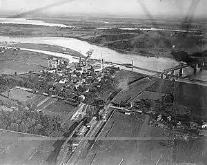
This aerial photo, from 1920, shows the canal paralleling the Saint Lawrence River.
Description
The canal extends past the Long Sault rapids from Cornwall, Ontario, to Dickinson's Landing. From the head of the Soulanges to the foot of the canal there is a stretch through Lake St. Francis of 32¾ miles. The length of the canal is eleven miles. It has six locks 270 by 45 feet. The total rise or lockage is 48 feet. The depth of water on the sill is 14 feet. It is 100 feet wide at the bottom and 164 at water surface.[4] It closed in 1968, after being functionally replaced by the Wiley-Dondero Canal on the US side of the river.
See also
References
- Parham, Claire (2009). The St. Lawrence Seaway and Power Project: An Oral History of the Greatest Construction Show on Earth. Syracuse University Press. p. 2. ISBN 978-0815651024. Retrieved 19 July 2017.
- Parham, Claire Puccia (2013). From Great Wilderness to Seaway Towns: A Comparative History of Cornwall, Ontario, and Massena, New York, 1784-2001. SUNY Press. p. 46. ISBN 978-0791485675.
- "Archived copy". Archived from the original on 2012-04-03. Retrieved 2011-03-10.CS1 maint: archived copy as title (link) Ontario Heritage Trust Founding of Cornwall
- This article incorporates text from a publication now in the public domain: . . 1914.
External links
 Media related to Cornwall Canal at Wikimedia Commons
This article is issued from Wikipedia. The text is licensed under Creative Commons - Attribution - Sharealike. Additional terms may apply for the media files.